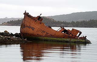
Conception Harbour is a town on the Avalon Peninsula in Newfoundland and Labrador, Canada. It is in Division 1 on Conception Bay and can be accessed via Newfoundland and Labrador Route 60.
Happy Adventure is an outport village on the Eastport Peninsula in the Canadian province of Newfoundland and Labrador. As of 2021, the population was 118.

Portugal Cove–St. Philip's is a rural seashore community located on the eastern Avalon Peninsula of Newfoundland in the province of Newfoundland and Labrador, Canada. The town is a bedroom community of the provincial capital of St. John's.

McCallum is a local service district and designated place in the Canadian province of Newfoundland and Labrador. It is on the southern coast of the island of Newfoundland. It is accessible only by boat or by air, and in appearance and way of life is thought by some to be as close to a pre-20th century community as may be found. McCallum lies in an enclosed harbour and is sheltered between two hills. The community survives primarily on the fishery. Whaling was also a major industry in the late 19th century. It is also about an hour and a half from the nearest road, in a community called Hermitage.

Sandy Cove is a town located on the Eastport Peninsula in Newfoundland and Labrador, Canada. It is located on Newman Sound, which is part of Bonavista Bay. It had a population of 120 in the 2021 census.

Rencontre East is a small, outport community in Newfoundland and Labrador, Canada located north east of Belleoram, and west of Terrenceville in Fortune Bay. The population was 115 in the 2021 census. This small community is not connected to any surrounding areas by road but is accessible by scheduled ferry service from ports in Pool's Cove and Bay L'Argent.

Rose Blanche – Harbour le Cou is a small town on Newfoundland's southwest shore, about 45 km at the end of Route 470 from Port aux Basques. This community is located in a barren area on the east side of a small bay. In this bay there are 2 harbours that were mainly used to provide shelter for fishing vessels. Scenery includes the rugged granite coastline, and the white and rocky cliffs of "Diamond Cove". Its granite lighthouse was in operation from 1873 to the 1940s. After it was abandoned in the 1940s the building fell into ruins. The spiral stone staircase extends into the tower wall and kept the tower from collapsing while the remainder of the lighthouse fell to ruin. In 1999 the lighthouse was fully reconstructed and serves as a tourist attraction.
Dover is a small incorporated fishing and lumbering village located in a small cove at the head of Freshwater Bay, Bonavista Bay, Newfoundland, Canada. Settled in the early 1890s it was originally known as Shoal Bay, presumably from its many shallow coves and inlets in the area. From the 1950s to the 1970 Shoal Bay was referred to as Wellington , whereas the local residents called it Dover.
Hermitage-Sandyville is a small town on the south coast of Newfoundland, Canada, with a population of 404 people in the 2021 Census. The main source of income for the community is provided by the Aquaculture industry, the local salmon plant and fishing.

Pool's Cove is a community located on the north west side of Fortune Bay, on the South Coast of Newfoundland, Canada. The town had a population of 143 in the 2021 Census.

Wabana is a Canadian town and the largest, and only incorporated, community on Bell Island in the province of Newfoundland and Labrador.
Admirals Beach is a rural community located in Newfoundland and Labrador, Canada.
Bay L'Argent is a town in the Canadian province of Newfoundland and Labrador.
Chance Cove is a town in the Canadian province of Newfoundland and Labrador. The town had a population of 213 in the Canada 2021 Census.
Lushes Bight–Beaumont–Beaumont North is a town on Long Island in Notre Dame Bay in the Canadian province of Newfoundland and Labrador. The town had a population of 169 at the 2021 Census, down from 275 in the 2006 Census.
Newman's Cove is a local service district and designated place in the Canadian province of Newfoundland and Labrador.
Lower Lance Cove is a local service district and designated place in the Canadian province of Newfoundland and Labrador.
Canning's Cove is a local service district and designated place in the Canadian province of Newfoundland and Labrador. It is on Bonavista Bay.

Birchy Cove is a local service district and designated place in the Canadian province of Newfoundland and Labrador.
Burnside-St. Chads is a local service district and designated place on the Eastport Peninsula in the Canadian province of Newfoundland and Labrador. A port is located in Burnside through which the MV Grace Sparkes services the isolated island outport of St. Brendan's. Burnside-St. Chads community had a population of 79 in the 2021 census.


