Aurora, Missouri

Last updated

Aurora, Missouri
Lawrence County Missouri Incorporated and Unincorporated areas Aurora Highlighted.svg
Location of Aurora, Missouri
Coordinates: 36°58′12″N93°43′14″W / 36.97000°N 93.72056°W / 36.97000; -93.72056
Country United States
State Missouri
County Lawrence
Founded1870
Incorporated 1885
Government
  TypeCouncil - Manager
Area
[1]
  Total6.33 sq mi (16.39 km2)
  Land6.30 sq mi (16.31 km2)
  Water0.03 sq mi (0.08 km2)
Elevation
1,401 ft (427 m)
Population
 (2020)
  Total7,219
  Estimate 
(2023)
7,512
  Density1,146.42/sq mi (442.64/km2)
Time zone UTC-6 (Central (CST))
  Summer (DST) UTC-5 (CDT)
ZIP code
65605
Area code 417
FIPS code 29-02548
GNIS feature ID0713486 [2]
Website aurora-cityhall.org

Aurora is a city in Lawrence County, Missouri, United States. As of the 2020 census, the population of the city was 7,219. [3]

Contents

History

The Honey Creek area, near Aurora was originally settled by pioneers from Tennessee, including James D. Hillhouse, E. B. Hillhouse, Reverend A. A. Young, James Barrow and James Gibson. They were later instrumental in founding Aurora. [4] Their descendants include actor Brad Pitt and novelist and national security analyst Raelynn Hillhouse.

Aurora was platted in 1870 by Stephen G. Elliott. [5] It was reportedly named after Aurora, the Roman goddess of dawn. [6]

Galena ore was discovered in 1885 while digging a well on the farm of Thomas D. Liles in November, marking the beginning of Aurora as a mining town. [7] Mining of surface outcrops began in 1886. [8] Large scale commercial mining began shortly afterwards as the mines grew deeper and zinc and galena were discovered. The zinc from the Aurora mines was of exceptional purity and high grade. By 1893, 12,651 tons of zinc ore were mined and shipped from Aurora. [8] The mines attracted prospectors and miners. Aurora's population peaked at 10,000 circa 1900.

The Frisco Railroad (now Burlington Northern-Santa Fe) and the Missouri Pacific (now Union Pacific) previously had depots in Aurora. The train master for the Missouri Pacific Railroad's White River division was headquartered in Aurora until the mid-1950s.

From 1911 to 1920, the virulently anti-Catholic newspaper The Menace was published in Aurora by W. F. Phelps and Earl McClure. In 1914, it achieved a national circulation of over one million, according to the March 1932 issue of American Mercury .

The Lewis Shaw Coleman House was listed on the National Register of Historic Places in 2016. [9]

Geography

Aurora is located at 36°58′12″N93°43′14″W / 36.97000°N 93.72056°W / 36.97000; -93.72056 (36.969956, -93.720574). [10] According to the United States Census Bureau, the city has a total area of 5.98 square miles (15.49 km2), of which 5.95 square miles (15.41 km2) is land and 0.03 square miles (0.08 km2) is water. [11]

Demographics

Historical population
CensusPop.Note
1890 3,482
1900 6,19177.8%
1910 4,148−33.0%
1920 3,575−13.8%
1930 3,8758.4%
1940 4,0564.7%
1950 4,1532.4%
1960 4,68312.8%
1970 5,35914.4%
1980 6,43720.1%
1990 6,4590.3%
2000 7,0148.6%
2010 7,5087.0%
2020 7,219−3.8%
U.S. Decennial Census [12]
2013 Estimate [13]

2010 census

As of the census [14] of 2010, there were 7,508 people, 2,948 households, and 1,943 families living in the city. The population density was 1,261.8 inhabitants per square mile (487.2/km2). There were 3,396 housing units at an average density of 570.8 per square mile (220.4/km2). The racial makeup of the city was 92.3% White, 0.3% African American, 0.9% Native American, 0.2% Asian, 0.1% Pacific Islander, 4.4% from other races, and 1.8% from two or more races. Hispanic or Latino of any race were 7.5% of the population.

There were 2,948 households, of which 36.1% had children under the age of 18 living with them, 46.8% were married couples living together, 14.0% had a female householder with no husband present, 5.1% had a male householder with no wife present, and 34.1% were non-families. 28.8% of all households were made up of individuals, and 13.2% had someone living alone who was 65 years of age or older. The average household size was 2.52 and the average family size was 3.09.

The median age in the city was 35.8 years. 27.6% of residents were under the age of 18; 8.2% were between the ages of 18 and 24; 25% were from 25 to 44; 23.4% were from 45 to 64; and 15.8% were 65 years of age or older. The gender makeup of the city was 47.2% male and 52.8% female.

2000 census

As of the census of 2000, there were 7,014 people, 2,818 households, and 1,865 families living in the city. The population density was 1,278.7 inhabitants per square mile (493.7/km2). There were 3,093 housing units at an average density of 563.9 per square mile (217.7/km2). The racial makeup of the city was 95.68% White, 0.26% African American, 0.83% Native American, 0.26% Asian, 1.34% from other races, and 1.64% from two or more races. Hispanic or Latino of any race were 2.71% of the population.

There were 2,818 households, out of which 33.2% had children under the age of 18 living with them, 50.9% were married couples living together, 11.2% had a female householder with no husband present, and 33.8% were non-families. 29.8% of all households were made up of individuals, and 16.0% had someone living alone who was 65 years of age or older. The average household size was 2.44 and the average family size was 3.02.

In the city the population was spread out, with 27.7% under the age of 18, 8.2% from 18 to 24, 26.4% from 25 to 44, 19.6% from 45 to 64, and 18.1% who were 65 years of age or older. The median age was 36 years. For every 100 females, there were 88.1 males. For every 100 females age 18 and over, there were 82.7 males.

The median income for a household in the city was $25,118, and the median income for a family was $33,029. Males had a median income of $27,591 versus $17,603 for females. The per capita income for the city was $13,410. About 14.4% of families and 18.2% of the population were below the poverty line, including 21.0% of those under age 18 and 15.6% of those age 65 or over.

Transportation

The Jerry Sumners Sr. Aurora Municipal Airport is located two nautical miles (2.3 mi, 3.7 km) southeast of Aurora's central business district. [15]

Education

Aurora R-VIII School District operates one early childhood school, one middle school, one Jr high school, and Aurora High School. [16]

Aurora has a public library, a branch of the Barry-Lawrence Regional Library. [17]

Media

The local newspaper is The Aurora Advertiser.

Notable people

Related Research Articles

<span class="mw-page-title-main">Aurora, Kansas</span> City in Cloud County, Kansas

Aurora is a city in Cloud County, Kansas, United States. As of the 2020 census, the population of the city was 56.

<span class="mw-page-title-main">Wheaton, Missouri</span> City in Missouri, United States

Wheaton is a city in Wheaton Township, Barry County, Missouri, United States. The population was 696 at the 2010 census.

<span class="mw-page-title-main">Ozark, Missouri</span> City in Missouri, United States

Ozark is a city in and the county seat of Christian County, Missouri. Its population was 21,284 as of the 2020 census. Ozark is also the third largest city in the Springfield, Missouri Metropolitan Area, and is centered along a business loop of U.S. Route 65, where it intersects with Missouri Route 14.

<span class="mw-page-title-main">St. Martins, Missouri</span> City in Missouri, United States

St. Martins or Saint Martins is a city in Cole County, Missouri, United States. The population was 1,191 at the 2020 census. It is part of the Jefferson City, Missouri Metropolitan Statistical Area.

<span class="mw-page-title-main">Ash Grove, Missouri</span> City in Missouri, United States

Ash Grove is a city in Greene County, Missouri, United States. The population was 1,512 at the 2020 census. It is part of the Springfield, Missouri Metropolitan Statistical Area.

<span class="mw-page-title-main">Craig, Missouri</span> City in Missouri, United States

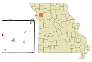
Craig is a city in Holt County, Missouri, United States. The population was 105 at the 2020 census.

<span class="mw-page-title-main">Willow Springs, Missouri</span> City in Missouri, United States

Willow Springs is a city in Howell County, Missouri, in the Ozark Mountains of the United States. The population was 2,164 at the 2020 census.

<span class="mw-page-title-main">Lebanon, Missouri</span> City in Missouri, United States

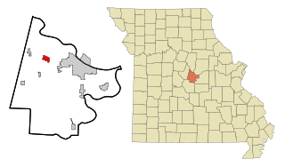
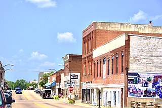
Lebanon is a city in and the county seat of Laclede County in Missouri. The population was 14,474 at the time of the 2010 census. It is the county seat of Laclede County. The Lebanon Micropolitan Statistical Area consists of Laclede County.

<span class="mw-page-title-main">Granby, Missouri</span> City in Missouri, United States

Granby is a city in Newton County, Missouri, United States. The population was 2,134 at the 2010 census. It is part of the Joplin, Missouri Metropolitan Statistical Area.

<span class="mw-page-title-main">Crystal Lakes, Missouri</span> City in Missouri, United States

Crystal Lakes is a city in western Ray County, Missouri, and part of the Kansas City metropolitan area within the United States. The population was 390 at the 2020 census.

<span class="mw-page-title-main">Centerville, Missouri</span> City in Missouri, United States

Centerville is a city in Reynolds County, Missouri, United States, situated along the West Fork of the Black River. The population was 167 at the 2020 census. It is the county seat of Reynolds County.

<span class="mw-page-title-main">Hazelwood, Missouri</span> City in Missouri, United States

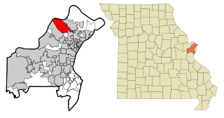
Hazelwood is a city in St. Louis County, Missouri, within Greater St. Louis. It is a second-ring northern suburb of St. Louis. Based on the 2020 United States census, the city had a total population of 25,485. It is located north of St. Louis-Lambert International Airport and is situated on Interstates 270 and 170, as well as the much-traveled Lindbergh Boulevard and Highway 370.

<span class="mw-page-title-main">Lakeshire, Missouri</span> City in Missouri, United States

Lakeshire is a city in St. Louis County, Missouri, United States. The population was 1,432 at the 2010 census.

<span class="mw-page-title-main">Winchester, Missouri</span> City in Missouri, United States

Winchester is a city in St. Louis County, Missouri, United States. The population was 1,447 at the 2020 census.

<span class="mw-page-title-main">Woodson Terrace, Missouri</span> City in Missouri, United States

Woodson Terrace is a city in St. Louis County, Missouri, United States. The population was 4,063 at the 2010 census.

<span class="mw-page-title-main">Essex, Missouri</span> City in Missouri, United States

Essex is a city in Stoddard County, Missouri, United States. The population was 472 at the 2010 census.

<span class="mw-page-title-main">Kimberling City, Missouri</span> City in Missouri, United States

Kimberling City is a city in Stone County, Missouri, United States. The population was 2,344 at the 2020 census.

<span class="mw-page-title-main">Moline Acres, Missouri</span> City in Missouri, United States

Moline Acres is a city in St. Louis County, Missouri, United States. The population was 2,442 at the 2010 census.

<span class="mw-page-title-main">Forsyth, Missouri</span> City in Missouri, United States

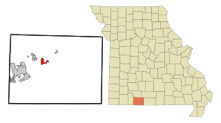
Forsyth is a city in Taney County, Missouri, United States. The population was 2,730 at the 2020 census. It is the county seat of Taney County. The town is part of the Branson, Missouri Micropolitan Statistical Area. Forsyth is located on Lake Taneycomo on U.S. Route 160.

<span class="mw-page-title-main">Gower, Missouri</span> City in Missouri, United States

Gower is a city in Buchanan and Clinton counties in the U.S. state of Missouri and is part of the Kansas City metropolitan area. The population was 1,533 at the 2020 census.

References

  1. "ArcGIS REST Services Directory". United States Census Bureau. Retrieved August 28, 2022.
  2. "US Board on Geographic Names". United States Geological Survey. October 25, 2007. Retrieved January 31, 2008.
  3. Bureau, US Census. "Population and Housing Unit Estimates Tables". The United States Census Bureau. Retrieved July 22, 2020.
  4. "Early History of Aurora". Aurora Missouri Historical Society. February 8, 2009. Retrieved October 28, 2021.
  5. "Lawrence County Place Names, 1928–1945 (archived)". The State Historical Society of Missouri. Archived from the original on June 24, 2016. Retrieved October 25, 2016.
  6. Eaton, David Wolfe (1916). How Missouri Counties, Towns and Streams Were Named. The State Historical Society of Missouri. pp.  184.
  7. "Historic Map - Aurora, MO - 1891". World Maps Online. Retrieved October 28, 2021.
  8. 1 2 Holibaugh, John R. (1895). The lead and zinc mining industry of southwest Missouri and southeast Kansas;. University of California. New York and London, The Scientific publishing co.
  9. "National Register of Historic Places Listings". Weekly List of Actions Taken on Properties: 10/17/16 through 10/21/16. National Park Service. October 28, 2016.
  10. "US Gazetteer files: 2010, 2000, and 1990". United States Census Bureau. February 12, 2011. Retrieved April 23, 2011.
  11. "US Gazetteer files 2010". United States Census Bureau. Archived from the original on January 25, 2012. Retrieved July 8, 2012.
  12. United States Census Bureau. "Census of Population and Housing" . Retrieved June 15, 2014.
  13. "Annual Estimates of the Resident Population: April 1, 2010 to July 1, 2013" . Retrieved June 15, 2014.
  14. "U.S. Census website". United States Census Bureau . Retrieved July 8, 2012.
  15. FAA Airport Form 5010 for 2H2 PDF . Federal Aviation Administration. Effective 30 June 2011.
  16. "Aurora R-Viii School District". Great Schools. Retrieved March 17, 2018.
  17. "Locations". Barry-Lawrence Regional Library. Retrieved March 17, 2018.
  18. Fulton, Kristine Anderson (August 28, 1992). "Hollywood comes home to traditional, down-home lifestyle". The Nevada Daily Mail . Nevada, MO. p. 1. Retrieved March 2, 2016.