Loch Lomond, Pompano Beach, Florida

Last updated
Loch Lomond, Florida
Coordinates: 26°16′19″N80°7′47″W / 26.27194°N 80.12972°W / 26.27194; -80.12972 Coordinates: 26°16′19″N80°7′47″W / 26.27194°N 80.12972°W / 26.27194; -80.12972
Country Flag of the United States.svg  United States
State Flag of Florida.svg  Florida
County   Broward
Area
  Total0.2 sq mi (0.6 km2)
  Land0.2 sq mi (0.6 km2)
  Water0.0 sq mi (0.0 km2)
Population
 (2000)
  Total3,537
  Density15,711.2/sq mi (6,066.1/km2)
Time zone UTC-5 (Eastern (EST))
  Summer (DST) UTC-4 (EDT)
FIPS code 12-40970 [1]

Loch Lomond is a former census-designated place (CDP) in Broward County, Florida, United States. The population was 3,537 at the 2000 census. It now serves as a Pompano Beach neighborhood.

Contents

Geography

Loch Lomond is located at 26°16′19″N80°7′47″W / 26.27194°N 80.12972°W / 26.27194; -80.12972 (26.272058, -80.129665). [2]

According to the United States Census Bureau, the CDP has a total area of 0.6 km2 (0.2 mi2), all land.

Demographics

As of the census [1] of 2000, there were 3,537 people, 1,399 households, and 790 families residing in the CDP. The population density was 5,937.6/km2 (15,711.2/mi2). There were 1,559 housing units at an average density of 2,617.1/km2 (6,925.0/mi2). The racial makeup of the CDP was 43.51% White (29.7% were Non-Hispanic White,) [3] 30.36% African American, 0.51% Native American, 1.61% Asian, 0.23% Pacific Islander, 10.09% from other races, and 13.68% from two or more races. Hispanic or Latino of any race were 24.63% of the population.

There were 1,399 households, out of which 34.0% had children under the age of 18 living with them, 30.0% were married couples living together, 17.5% had a female householder with no husband present, and 43.5% were non-families. 28.9% of all households were made up of individuals, and 4.9% had someone living alone who was 65 years of age or older. The average household size was 2.53 and the average family size was 3.09.

In the CDP, the population was spread out, with 23.6% under the age of 18, 13.6% from 18 to 24, 44.2% from 25 to 44, 14.1% from 45 to 64, and 4.4% who were 65 years of age or older. The median age was 30 years. For every 100 females, there were 120.0 males. For every 100 females age 18 and over, there were 125.6 males.

The median income for a household in the CDP was $23,646, and the median income for a family was $23,365. Males had a median income of $21,660 versus $16,202 for females. The per capita income for the CDP was $11,862. About 28.6% of families and 30.7% of the population were below the poverty line, including 44.6% of those under age 18 and 3.6% of those age 65 or over.

As of 2000, English as a first language accounted for 32.49% of all residents, while Spanish accounted for 28.79%, French Creole made up 20.22%, Portuguese was at 17.11%, and French was the mother tongue of 1.38% of the population. [4]

Related Research Articles

Hamilton Branch, California census-designated place in California, United States

Hamilton Branch is a census-designated place (CDP) in Plumas County, California, United States. The population was 587 at the 2000 census.

Ben Lomond, California Census-designated place in Santa Cruz County, California, US

Ben Lomond is a census-designated place (CDP) in Santa Cruz County, California, United States, and also the name of the mountain to the west. The population was 6,234 at the 2010 census.

Cocoa West, Florida CDP in Florida, United States

Cocoa West is a census-designated place (CDP) in Brevard County, Florida, United States. The population was 5,925 at the 2010 census. It is the closest place to Lake Poinsett and Canaveral Groves.

Bonnie Loch-Woodsetter North is a former census-designated place (CDP) in Broward County, Florida. The population was 4,275 at the 2000 census. According to the U.S. Census errata, the area was misspelled as "Bonnie Lock-Woodsetter North".

Brunswick Station, Maine Census-designated place in Maine, United States

Brunswick Station is a census-designated place (CDP) within the town of Brunswick in Cumberland County, Maine, United States. The population was 578 at the 2010 census. It consists of area that was part of the former Naval Air Station Brunswick. The CDP is part of the Portland–South Portland–Biddeford, Maine Metropolitan Statistical Area.

Fairmount, Maryland CDP in Maryland, United States

Fairmount is a census-designated place (CDP) in Somerset County, Maryland, United States. The population was 537 at the 2000 census. It is included in the Salisbury, Maryland-Delaware Metropolitan Statistical Area.

Popponesset, Massachusetts Census-designated place in Massachusetts, United States

Popponesset is a census-designated place (CDP) in the town of Mashpee in Barnstable County, Massachusetts, United States. The population was 220 at the 2010 census.

Gulf Park Estates, Mississippi Census-designated place in Mississippi, United States

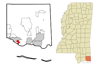
Gulf Park Estates is an unincorporated community and census-designated place (CDP) located south of Ocean Springs in Jackson County, Mississippi, United States. It is part of the Pascagoula Metropolitan Statistical Area. The population was 5,719 at the 2010 census, up from 4,272 at the 2000 census.

Garden City South, New York Hamlet and census-designated place in New York, United States

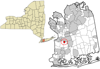
Garden City South is a hamlet and census-designated place (CDP) in Nassau County, New York, United States. The population was 4,024 at the 2010 census.

Altamahaw, North Carolina Census-designated place in North Carolina, United States

Altamahaw is a census-designated place (CDP) in Alamance County, North Carolina, United States. It is part of the Burlington, North Carolina Metropolitan Statistical Area. As of the 2010 census it had a population of 347. The community was listed as Altamahaw-Ossipee at the 2000 census, at which time the population was 996. The town of Ossipee incorporated in 2002 and currently has a population of 543. The remainder of the territory was reassigned as the Altamahaw CDP.

La Croft, Ohio Census-designated place in Ohio, United States

La Croft is a census-designated place (CDP) in Columbiana County, Ohio, United States. The population was 1,144 at the 2010 census.

Woodbourne-Hyde Park, Ohio Unincorporated community & former census-designated place in Ohio, United States

Woodbourne-Hyde Park is an unincorporated area in Washington Township in Montgomery County, Ohio, United States. It was delineated as a census-designated place (CDP) at the 2000 census, at which time its population was 7,910. It was not delineated as a CDP for the 2010 census.

Carnot-Moon, Pennsylvania Census-designated place in Pennsylvania, United States

Carnot-Moon is a census-designated place (CDP) in central Moon Township, Allegheny County, Pennsylvania, United States. The population was 11,372 at the 2010 census.

Hyde, Pennsylvania Census-designated place in Pennsylvania, United States

Hyde is an unincorporated community and census-designated place (CDP) in Clearfield County, Pennsylvania, United States. The population was 1,399 at the 2010 census.

Gastonville, Pennsylvania Census-designated place in Pennsylvania, United States

Gastonville is a census-designated place (CDP) in Washington County, Pennsylvania, United States. The population was 2,818 at the 2010 census.

Indian Hills, Texas Census-designated place in Texas

Indian Hills is a census-designated place (CDP) in Hidalgo County, Texas, United States. At the 2010 United States Census, the population was 2,591. It is part of the McAllen–Edinburg–Mission Metropolitan Statistical Area.

Lipscomb, Texas CDP in Texas, United States

Lipscomb is a census-designated place (CDP) in, and the county seat of, Lipscomb County, Texas, United States. The population was 37 at the 2010 census.

Imperial, Texas CDP in Texas, United States

Imperial is a census-designated place (CDP) in Pecos County, Texas, United States. The population was 278 at the 2010 census.

Loch Lomond, Virginia Census-designated place in Virginia, United States

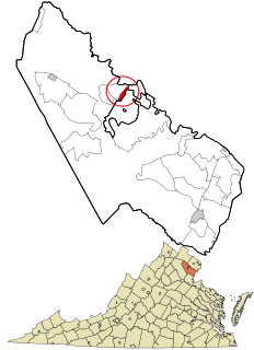
Loch Lomond is a census-designated place (CDP) in Prince William County, Virginia, United States. The population was 3,701 at the 2010 census. It is named after a lake in northern Scotland, Loch Lomond.

Hooverson Heights, West Virginia Census-designated place in West Virginia, United States

Hooverson Heights is a census-designated place (CDP) in Brooke County, West Virginia, United States. It is part of the Weirton-Steubenville, WV-OH Metropolitan Statistical Area. The population was 2,590 at the 2010 census.

References

  1. 1 2 "U.S. Census website". United States Census Bureau . Retrieved 2008-01-31.
  2. "US Gazetteer files: 2010, 2000, and 1990". United States Census Bureau. 2011-02-12. Retrieved 2011-04-23.
  3. "Demographics of Loch Lomond, FL". MuniNetGuide.com. Archived from the original on 2008-04-28. Retrieved 2007-11-16.
  4. "MLA Data Center Results for Loch Lomond, FL". Modern Language Association . Retrieved 2007-11-16.