| ||
The 1983 New South Wales local elections were held on 24 September 1983 to elect the councils of the local government areas (LGAs) of New South Wales, Australia. [3] [4] [5]
| ||
The 1983 New South Wales local elections were held on 24 September 1983 to elect the councils of the local government areas (LGAs) of New South Wales, Australia. [3] [4] [5]
A number of councils had their structures altered prior to the 1983 elections. Bogan was reduced from ten to nine, [6] Tumut was reduced from ten to eight, [7] Warren increased from ten to twelve [8] and Wellington increased from ten to eleven. [9]
Gloucester, Kyogle, Murray, Murrumbidgee and Tallaganda were all increased from eight to nine councillors. [10] [11] [12] [13] [14]
In August 1983, local government minister Lin Gordon announced that elections for 13 councils would be postponed until 10 December 1983 while possible amalgamations were considered. [15] The City of Sydney and the municipalities of Ashfield, Botany, Burwood, Canterbury, Concord, Drummoyne, Leichhardt, Marrickville, Randwick, Strathfield, Waverley and Woollahra were all affected. [15]
A number of these councils appear to have eventually gone ahead with elections as planned on 24 September. [16] [17] However, Ashfield, Canterbury, Leichhardt and Sydney did not, with their elections moved to 14 April 1984. [18] [19] [20] [21]
The Liberal Party, which contested a number of LGAs for the first time, had a swing towards them. [16] In Wollongong, one member of the Active Community Team (ACT) was elected, while A Women in Local Government (WILGO) was unsuccessful. [16]
In Blue Mountains, the Communist Party of Australia unsuccessfully contested Ward 1 and Ward 4, receiving 1.91% and 1.94% of the vote respectively. [16] [22]
Ted Mack was re-elected as mayor of North Sydney with 70% of the vote. [16]
At least one referendum was held.
| LGA | Question | YES | NO | Informal | Turnout | Ref | ||||
|---|---|---|---|---|---|---|---|---|---|---|
| Votes | % | Votes | % | Votes | % | Total | % | |||
| Bega Valley | "Should Bega Valley shire be declared a nuclear-free zone?" (exact wording unknown) | 6,056 | 55.62 | 4,832 | 44.38 | [16] [23] | ||||

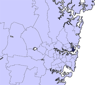
This is a list of local government areas (LGAs) in New South Wales, sorted by region. As of September 2024 there were 128 local government areas in New South Wales, there are 33 local government areas in Greater Sydney and 95 local government areas and 12 regions in Regional NSW. All councils are listed below in alphabetical order by region. There is also the Unincorporated Far West Region which is not part of any local government area, in the sparsely inhabited Far West, and Lord Howe Island, which is also unincorporated but self-governed by the Lord Howe Island Board.

Warringah Council was a local government area in the northern beaches region of Sydney, in the state of New South Wales, Australia. It was proclaimed on 7 March 1906 as the Warringah Shire Council, and became "Warringah Council" in 1993. In 1992, Pittwater Council was formed when the former A Riding of Warringah Shire voted to secede. From this point on until amalgamation, Warringah Council administered 152 square kilometres (59 sq mi) of land, including nine beaches and 14 kilometres (9 mi) of coastline. Prior to its abolition it contained 6,000 hectares of natural bushland and open space, with Narrabeen Lagoon marking Warringah's northern boundary and Manly Lagoon marking the southern boundary.

The City of Gosford was a local government area that was located in the Central Coast region in the state of New South Wales, Australia. The incorporation of Gosford dates back to 1886 when the Town of Gosford was proclaimed as the Borough of Gosford, becoming the Municipality of Gosford from 1906. In 1908, the Gosford Municipality merged into Erina Shire which covered the remaining Central Coast area outside of Gosford, but regained its independence in 1936. From 1 January 1947, local government in the Central Coast region was reorganised, creating Gosford Shire and Wyong Shire, and the final boundaries of Gosford City Council date from this period. From 1 January 1980, Gosford Shire was granted city status, becoming the City of Gosford. On 12 May 2016 the Minister for Local Government amalgamated the City of Gosford and Wyong Shire Councils to form the new Central Coast Council.

The Municipality of Ashfield was a local government area in the Inner West of Sydney, New South Wales, Australia. It is about 10 kilometres (6.2 mi) west of the Sydney central business district. The municipality was proclaimed on 28 December 1871 as the "Borough of Ashfield", which changed to the "Municipality of Ashfield" in 1906. On 12 May 2016, Ashfield merged with Marrickville Council and the Municipality of Leichhardt to form the Inner West Council.

The Municipality of Leichhardt was a local government area in the inner-west region of Sydney, New South Wales, Australia. It is about 10 kilometres (6.2 mi) west of the Sydney central business district. On 12 May 2016, Leichhardt merged with Marrickville Council and the Municipality of Ashfield to form the Inner West Council.

Marrickville Council was a local government area located in the Inner West region of Sydney, Australia. It was originally created on 1 November 1861 as the "Municipality of Marrickville". On 12 May 2016, Marrickville Council was forcibly merged with Ashfield and Leichhardt councils into the newly formed Inner West Council.
Mosman Council is a local government area on the Lower North Shore of Sydney, New South Wales, Australia.

North Sydney Council is a local government area on the Lower North Shore of Sydney, New South Wales, Australia, established on 29 July 1890 through the amalgamation of three boroughs.

The City of Ryde is a local government area in the Northern Sydney region, in New South Wales, Australia. It was first established as the Municipal District of Ryde in 1870, became a municipality in 1906 and was proclaimed as the City of Ryde in 1992.

Leeton Shire is a local government area in the Riverina region of New South Wales, Australia. The Shire is located adjacent to the Murrumbidgee River and falls within the Murrumbidgee Irrigation Area.

Wollondilly Shire is a periurban local government area, located on the south west fringe of the Greater Sydney area in New South Wales, Australia, parts of which fall into the Macarthur, Blue Mountains and Central Tablelands regions in the state of New South Wales, Australia. Wollondilly is seen as the transition between Regional NSW and the Greater Sydney Region, and is variously categorised as part of both. Wollondilly Shire was created by proclamation in the NSW Government Gazette on 7 March 1906, following the passing of the Local Government (Shires) Act 1905, and amalgamated with the Municipality of Picton on 1 May 1940.

Canterbury-Bankstown Council, trading as the City of Canterbury Bankstown, is a local government area in the Canterbury-Bankstown region of Sydney, New South Wales, Australia. The council was formed on 12 May 2016 from a merger of the City of Canterbury and the City of Bankstown, after a review of local government areas by the NSW Government.

The Central Coast Council is a local government area in the Central Coast region of New South Wales, Australia. It is adjacent to the Pacific Highway, Central Coast Highway, the Northern railway line and the Pacific Ocean. The council was formed on 12 May 2016 following the merger of the City of Gosford and Wyong Shire Councils.

Inner West Council is a local government area located in the Inner West region of Sydney in the state of New South Wales, Australia. The council makes up the eastern part of this wider region, and was formed on 12 May 2016 from the merger of the former Ashfield, Leichhardt and Marrickville councils.
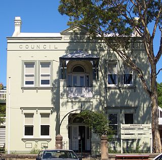
The Municipality of Annandale was a local government area of Sydney, New South Wales, Australia. The municipality was proclaimed on 29 December 1893 as the Borough of Annandale when the East Ward of Leichhardt Council separated, and, with an area of 1.4 square kilometres, covered the entire suburb of Annandale, excepting a small block between Johnstons Creek, Booth Street and Parramatta Road. The council was amalgamated with the Municipality of Leichhardt to the west with the passing of the Local Government (Areas) Act 1948.

Local Government (Shires) Act 1905 was a landmark New South Wales statute notable for the compulsory incorporation of local government areas for around 40% of the area of New South Wales. The Act created 134 rural shires, many surrounding a small urban area separately and voluntarily incorporated under the Municipalities Act 1858 and the following Municipalities Act 1867 and Municipalities Act 1897 As well as the compulsory incorporation of rural areas, the Local Government (Shires) Act repealed the Municipalities Act - bringing local government under one legislative framework.
Kearsley Shire was a local government area in the Hunter region of New South Wales, Australia.
The Shire of Woy Woy was a local government area on the Central Coast region of New South Wales, Australia, centred on the town of Woy Woy. The shire was proclaimed on 1 August 1928 as a result of the proclamation of the separation of the D Riding of Erina Shire and had its council seat at Woy Woy, but covered the majority of the Woy Woy peninsula including Woy Woy Bay, Umina, Blackwall, Kariong, Pearl Beach, and Patonga. Woy Woy Shire was abolished on 1 January 1947 with the reorganisation of local government in the Central Coast region following the end of the Second World War, with the council area amalgamated into Gosford Shire.
The 1987 New South Wales local elections were held on 26 September 1987 to elect the councils of the local government areas (LGAs) of New South Wales, Australia.