2018 Southern California mudflows

Last updated
2018 Southern California debris flows
Santa barbara county neighborhood affected mudslides - 09 Jan 2018.jpg
Homes and streets of a neighborhood affected by the Santa Barbara County mudslides
DateJanuary 9, 2018 (2018-01-09)
Location Southern California, United States
CauseSoil saturation from heavy rainfall, and deforestation due to recent wildfires
Deaths23 [1]
Non-fatal injuries163
Property damage>$207 million (2018 USD) [2] [3]
  • 65 residences destroyed, 462 residences damaged, 8 commercial buildings destroyed, 20 commercial buildings damaged

A series of mudflows occurred in Southern California in early January 2018, particularly affecting areas northwest of Montecito in Santa Barbara County. The incident was responsible for 23 deaths, [4] although the body of one of the victims has never been found. [5] Approximately 163 people were hospitalized with various injuries, including four in critical condition. [6] The disaster occurred one month after a series of major wildfires. The conflagrations devastated steep slopes, which caused loss of vegetation and destabilization of the soil and greatly facilitated subsequent mudflows. The mudflows caused at least $177 million (2018 USD) in property damage, [2] and cost at least $7 million in emergency responses [2] and another $43 million (2018 USD) to clean up. [3]

Contents

Background

The 2017 California wildfire season was at the time the most destructive in California's history, with approximately 9,133 wildfires that burned over 1.3 million acres (5,300 km2) and killed 46 people. [7] At the beginning of December, the Santa Ana winds fanned wildfires across southern California, which were fueled by a lack of rainfall during what is normally the region's rainy season. [8] The December fires burned 307,953 acres (124,624 ha) of which 281,893 acres (114,078 ha) were burned during the Thomas Fire, the largest fire in the state's history at the time. [4] [5] The Thomas Fire, which devastated parts of Santa Barbara and Ventura counties, burned large amounts of vegetation whose roots had helped stabilize topsoil in hillsides and other vulnerable areas. [9] After burning for more than a month, the fire was declared fully contained on January 12, 2018. [10]

A strong low-pressure system and cold front developed off the coast of California on January 5, 2018. [11] The system moved onto the mainland on January 8, bringing heavy rain to Southern California and prompting mandatory evacuations in parts of Los Angeles, Santa Barbara, and Ventura counties, over potential mudslides in areas affected by wildfires. [12] The storm intensified on the following day, with at least four inches (100 mm) of rain falling over the two-day period, before ending on January 9, causing several major mudflows. [13] [14]

Landslides

Santa Barbara County

2018 Southern California mudflows
Location of the Montecito mudflow
San Ysidro Ck. after debris flow SY Ranch & Casa de Maria Debris Flow 180111-04783.jpg
San Ysidro Ck. after debris flow
Butterfly Beach debris 180111 4228 Butterfly Beach Mud Flow.jpg
Butterfly Beach debris

Early on the morning of January 9, mudflows struck Montecito, which had been affected by the Thomas Fire, and other areas of Santa Barbara County. [15] An estimated 0.5 inches (13 mm) of rain fell within a five-minute period at approximately 3:30 a.m., causing mud and boulders from the Santa Ynez Mountains to flow down creeks and valleys into Montecito. [16] The debris flows were up to 15 feet (5 m) in height of mud, boulders and tree branches, moving at estimated speeds of up to 20 miles per hour (30 km/h) into the lower areas of Montecito. [17] [18] Over 20,000 people lost power, and a 30-mile (50 km) section of U.S. Route 101 (US 101) from Santa Barbara to Ventura was shut down as sections filled with two feet (60 cm) of mud and debris, some of which also reached beaches 2.25 miles (3.6 km) from the mountains. [19] [20] [21] Following the closure, access to Santa Barbara from the Los Angeles area was limited to a 260-mile (420 km) detour around the Los Padres National Forest or through the use of private ferries to Ventura. [22] On January 11, Amtrak train service was restored to Santa Barbara and US 101 was partially reopened as far west as Carpinteria. [23] The highway was fully reopened on January 21, after Caltrans crews cleared 12 feet (3.7 m) of mud from the roadway. [24] [25]

Approximately 21,000 residents of Santa Barbara and Ventura counties in high elevation zones affected by the Thomas Fire were evacuated, [26] but low-lying areas were outside of the mandatory evacuation area. [27] [28] Warning messages sent by the National Weather Service and the county government arrived too late to prompt Montecito residents to seek safe areas. [29] Many residents in the mandatory evacuation zone, and most residents in the voluntary evacuation area, ignored warnings and stayed in their homes, probably a result of "evacuation fatigue" left over from the recent wildfires. [30] The mandatory evacuation zone was expanded to cover a majority of Montecito's estimated 10,000 residents two days later (January 11) due to disruptions in electricity, gas, water, sewage and Internet, and due to emergency road works and ongoing search and rescue operations. [31]

The mudflows caused 23 confirmed deaths, mostly in the Montecito area. One body, that of two-year-old Lydia Sutthithepa, was never recovered. [32] Over 150 people were hospitalized with various injuries, including four in critical condition. [6] The mudflows destroyed over 100 homes and damaged an additional 300. [33] Writer T.C. Boyle, whose home was proximate to both the fire and mudslides, documented the collective trauma in The New Yorker magazine. [34]

Cleanup efforts began a week after the initial mudflows, with debris being sent to the Ventura County Fairgrounds for sorting and the Calabasas Landfill for disposal. [35] [36]

Los Angeles County

Parts of Burbank and Sun Valley, previously affected by the La Tuna Fire in 2017, received four inches (100 mm) of rain and were evacuated ahead of potential mudslides. A debris flow into a residential area of Sun Valley damaged 40 to 45 homes and carried a vehicle that struck a natural gas pipeline, which began to leak. [37] Mandatory evacuations were ordered for nearby areas of the San Fernando Valley affected by the Creek Fire before the storm, but no major damage was reported. [38] [39]

Orange and Riverside counties

Heavy rain in Corona, affected by the Canyon Fire, covered streets with mud and flooded into several homes, but no major damage was reported. [40]

Response

More than 1,250 firefighters from California and other states, along with the California Conservation Corps and California National Guard, were dispatched to Santa Barbara County for search and rescue operations. [27] [17] Numerous civilian volunteers also came out in force to help with the clean up effort. The Federal Emergency Management Agency announced that emergency assistance funds related to the wildfires would be extended to cover damage from the mudflows. [41] The U.S. Army Corps of Engineers also worked quickly in awarding contracts that involved removal of debris from various water basins and channels.[ citation needed ]

Approximately 300 residents of the Romero Canyon neighborhood near Montecito were rescued via a helicopter airlift after roads were blocked by debris. [42]

See also

Related Research Articles

<span class="mw-page-title-main">Montecito, California</span> Town in California

Montecito is an unincorporated town and census-designated place in Santa Barbara County, California, United States. Located on the Central Coast of California, Montecito sits between the Santa Ynez Mountains and the Pacific Ocean. Montecito is best known as a celebrity enclave, owing to its concentration of prominent residents. The population as of 2022 is approximately 8,638 residents.

<span class="mw-page-title-main">Westmont College</span> Private Christian liberal arts college

Westmont College is a private Christian liberal arts college in Montecito, California. It was founded in 1937.

A sundowner is a northerly offshore wind in California along the southern Pacific slope of Santa Ynez Mountains, in communities along the Gaviota Coast and Santa Barbara towards but not including Ventura County.

<span class="mw-page-title-main">Tea Fire</span>

The Tea Fire, also known as the Montecito Tea Fire, was a wildfire that began on November 13, 2008, destroying 210 homes in the cities of Montecito and Santa Barbara, California, in the United States of America. It was the first of several November 2008 wildfires that burned hundreds of homes from November 13–15, 2008. The Tea Fire ignited in the Cold Springs section of Montecito at approximately 17:50 PST on November 13, 2008. The fire started at a Mar Y Cel historic structure called the "Tea House" above Mountain Drive, giving the fire its name. Spreading rapidly, it was fanned by offshore winds, known as Sundowner winds, that blow down the Santa Ynez Mountains, gusting up to 85 mph (137 km/h). These winds caused the fire to spread into the city of Santa Barbara. The fire was 40% contained on the 15th, 75% on the 16th, and by November 17, 2008, it was 95% contained after burning 1,940 acres, and on November 18, it was 100% contained.

<span class="mw-page-title-main">Jesusita Fire</span> 2009 wildfire in Santa Barbara, California

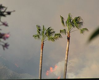
The Jesusita Fire was a wildfire that started on May 5, 2009, in the hills of Santa Barbara, California in the western United States. By the time the fire was contained on May 18 it had burned 8,733 acres (35.34 km2), destroyed 80 homes and damaged 15 more before being 100% contained. The cause of the fire was ultimately traced to local contractors who had left gas cans and hot equipment unattended in dry brush after clearing part of the Jesusita Trail using a weed wacker without any permits or the permission of the landowner.

<span class="mw-page-title-main">Springs Fire</span>

The Springs Fire was a wildfire in Ventura County, California in May 2013. Although the fire burned only 15 homes, it threatened 4,000. This threat passed when rain shower moved through the California area because of a low-pressure system off the coast. Some places got more than half an inch of rain.

<span class="mw-page-title-main">Cuesta Fire</span>

The Cuesta fire was a wildfire that started on 16 August 2015 near U.S. Route 101 and the Cuesta Grade, in the Santa Lucia Range just north of San Luis Obispo in San Luis Obispo County, California. The fire was contained on 28 August, and had burned 2,446 acres, some within the Los Padres National Forest.

<span class="mw-page-title-main">Simi Fire</span> 2003 wildfire in California

The Simi Fire was a devastating 2003 wildfire that burned 108,204 acres (438 km2) of land in the Simi Hills and southeastern Simi Valley in eastern Ventura County and western Los Angeles County, in the U.S. state of California. The Simi Fire was one of multiple large, fast-moving, and destructive wildfires in Southern California in October 2003, in a fire siege that included the Cedar, Old, and Grand Prix fires. The Simi Fire resulted in no fatalities, but did cause 21 injuries. The cause of the fire remains unknown.

<span class="mw-page-title-main">Sherpa Fire</span> 2016 wildfire in California

The Sherpa Fire was a wildfire that burned in the Santa Ynez Mountains along the Gaviota Coast in the southwestern part of Santa Barbara County, California in June 2016. In a matter of hours the fire spread to over 1,400 acres (570 ha) as the fire was propelled by downslope sundowner winds. This offshore northerly wind contrasts with the more typical onshore flow and sent the fire down the canyons towards the ocean with gusts of over 35 miles per hour (56 km/h). The wildfire resulted in evacuations at two state beach campgrounds and some residences together with intermittent interruption of traffic on a state transportation route.

<span class="mw-page-title-main">2017 California wildfires</span> An overview of major wildfires in California during the year 2017

In terms of property damage, 2017 was the most destructive wildfire season on record in California at the time, surpassed by only the 2018 season and the 2020 season, with a total of 9,560 fires burning 1,548,429 acres (6,266.27 km2) of land, according to the California Department of Forestry and Fire Protection, including five of the 20 most destructive wildland-urban interface fires in the state's history. Throughout 2017, the fires destroyed or damaged more than 10,000 structures in the state, a higher tally than the previous nine years combined. State data showed that the large wildfires killed 47 people – 45 civilians and 2 firefighters – almost higher than the previous 10 years combined. The total property damage and total amount of burned land were both surpassed by the 2018 California wildfires.

The La Tuna Fire was a wildfire that started on September 1, 2017, and burned 7,194 acres (2,911 ha) through the Verdugo Mountains in Los Angeles, California. It led to the destruction of 5 homes and the evacuations of over 300 homes. It was the largest wildfire in the city of Los Angeles in 50 years.

<span class="mw-page-title-main">Thomas Fire</span> 2017 wildfire in Ventura County, California

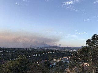
The Thomas Fire was a massive wildfire that affected Ventura and Santa Barbara Counties, and one of multiple wildfires that ignited in southern California in December 2017. It burned approximately 281,893 acres before being fully contained on January 12, 2018, making it the largest wildfire in modern California history at the time. It was surpassed by the Ranch Fire, part of the Mendocino Complex, in August 2018. The fire is currently the seventh-largest wildfire in modern California history, as of 2021. The fire was officially declared out on June 1, 2018, after more than two months in which no hotspots were detected. The Thomas Fire destroyed at least 1,063 structures, while damaging 280 others; and the fire caused over $2.2 billion in damages, including $230 million in suppression costs, becoming the seventh-most destructive wildfire in state history at the time. As of August 2020, the Thomas Fire is California's tenth-most destructive wildfire. Ventura's agriculture industry suffered at least $171 million in losses due to the Thomas Fire.

<span class="mw-page-title-main">Creek Fire (2017)</span> 2017 wildfire in Southern California, United States

The Creek Fire was a large wildfire that burned in Kagel Canyon and the Angeles National Forest north of Sylmar, a neighborhood in Los Angeles, California, United States, and one of multiple wildfires that broke out across Southern California in December 2017. The Creek Fire burned 15,619 acres (63 km2) and destroyed 123 structures, including 60 homes, before being contained on January 9, 2018, following heavy rainfall from a winter storm. The fire threatened the communities of Santa Clarita, Glendale, Olive View, Lake View Terrace, Sunland-Tujunga, Shadow Hills, Sylmar, Pacoima, Lopez Canyon, and Kagel Canyon, as well as the Olive View–UCLA Medical Center. During the wildfire, 115,000 residents were forced to evacuate their homes.

<span class="mw-page-title-main">December 2017 Southern California wildfires</span> 2017 wildfires in Southern California

A series of 29 wildfires ignited across Southern California in December 2017. Six of the fires became significant wildfires, and led to widespread evacuations and property losses. The wildfires burned over 307,900 acres (1,246 km2), and caused traffic disruptions, school closures, hazardous air conditions, and power outages; over 230,000 people were forced to evacuate. The largest of the wildfires was the Thomas Fire, which grew to 281,893 acres (1,140.78 km2), and became the largest wildfire in modern California history, until it was surpassed by the Ranch Fire in the Mendocino Complex, in the following year.

The January 2018 American West floods occurred due to heavy precipitation in the Western United States. While wildfires in Southern California exacerbated the rain's effects there, other states, like Nevada, also experienced flooding.

<span class="mw-page-title-main">Woolsey Fire</span> Large 2018 wildfire in southern California

The Woolsey Fire was a wildfire that burned in Los Angeles and Ventura Counties of the U.S. state of California. The fire ignited on November 8, 2018, and burned 96,949 acres of land. The fire destroyed 1,643 structures, killed three people, and prompted the evacuation of more than 295,000 people. It was one of several fires in California that ignited on the same day, along with the nearby Hill Fire and the destructive Camp Fire in Northern California.

<span class="mw-page-title-main">El Dorado Fire</span> 2020 wildfire in San Bernardino County, California

The El Dorado Fire burned 22,744 acres in San Bernardino and Riverside counties of California from September to November 2020. It was ignited on September 5 by a pyrotechnic device at a gender reveal party in El Dorado Ranch Park; it quickly spread to the San Gorgonio Wilderness Area of the San Bernardino National Forest. Burning over a 71-day period, the fire destroyed 20 structures and resulted in one firefighter fatality, for which the couple hosting the party were charged with involuntary manslaughter.

<span class="mw-page-title-main">Silverado Fire</span> 2020 wildfire in California, United States

The Silverado Fire was a wildfire that burned in October and November 2020 in southern Orange County, California northeast of Irvine. The fire started on October 26 around 6:47 AM near Orange County Route S-18 and Silverado Canyon Road, fueled by strong Santa Ana winds gusting up to 80 miles per hour (130 km/h) and low humidity. Orange County Fire Authority Chief Brian Fennessy stated, "The winds were extraordinary even by Santa Ana standards. Fire spread is exceeding more than anything I've seen in my 44 years." The fire initially moved south from Loma Ridge toward the Orchard Hills, Northwood and Portola Springs communities of Irvine before moving southeast through Limestone Canyon and toward the communities of Foothill Ranch and Lake Forest. The fire burned in a path similar to that taken by the 2007 Santiago Fire, mostly through terrain that had not seen significant burning in the 13 years since that fire. 100% containment was announced on November 7, 2020.

<span class="mw-page-title-main">Bond Fire</span> 2020 wildfire in California, United States

The Bond Fire was a wildfire that burned 6,686 acres (2,706 ha) in the Santiago Canyon area of Orange County, California in December 2020. The fire caused evacuations of 25,000 residents and injured 2 firefighters. The fire was very close to the burn scar of the Silverado Fire, which took place in October 2020.

<span class="mw-page-title-main">2022–2023 California floods</span> Regional natural disaster event

Periods of heavy rainfall caused by multiple atmospheric rivers in California between December 31, 2022 and March 25, 2023 resulted in floods that affected parts of Southern California, the California Central Coast, Northern California and Nevada. The flooding resulted in property damage and at least 22 fatalities. At least 200,000 homes and business lost power during the December-January storms and 6,000 individuals were ordered to evacuate.

References

  1. Martinez, Alys (January 9, 2019). "One year later, symbol of hope found in Montecito mud". KEYT 3. Archived from the original on May 6, 2019. Retrieved May 6, 2019.
  2. 1 2 3 "The Economic Impacts of the Montecito Mudslides: A Preliminary Assessment" (PDF). Robert D. Niehaus, Inc. March 2018. Archived from the original (PDF) on 26 May 2018. Retrieved 26 May 2018.
  3. 1 2 Giana Magnoli (27 February 2018). "County Estimates $46 Million Cost for Thomas Fire, Montecito Debris Flow Response, Repairs". Noozhawk. Retrieved 26 May 2018.
  4. 1 2 Sanders, Linley (December 22, 2017). "California's Thomas Fire Breaks Record As Largest Wildfire in State History". Newsweek . Retrieved January 10, 2018.
  5. 1 2 Flores, Oscar (December 4, 2017). "Thomas Fire burns 281,893 acres, nears full containment". KEYT 3 . Retrieved January 10, 2018.
  6. 1 2 "California: Thirteen dead in Montecito rains and mudslides". BBC News . January 10, 2018. Retrieved January 11, 2018.
  7. Tierney, Lauren (January 4, 2018). "The grim scope of 2017's California wildfire season is now clear. The danger's not over". The Washington Post . Retrieved January 10, 2018.
  8. Holthaus, Eric (December 14, 2017). "The Thomas Fire Could Become the Largest Wildfire in California History". Pacific Standard . Retrieved January 10, 2018.
  9. Serna, Joseph; Panzar, Javier (January 8, 2018). "Rains finally arrive, bringing new danger in California's vast fire zones". Los Angeles Times. Retrieved January 10, 2018.
  10. Livingston, Michael; Grad, Shelby (January 12, 2018). "Thomas fire, California's largest on record, finally 100% contained". Los Angeles Times. Retrieved January 12, 2018.
  11. Lindsey, John (January 6, 2018). "SLO County is expected to get heavy rain Monday and Tuesday — here's why". The Tribune . San Luis Obispo. Retrieved January 10, 2018.
  12. von Quednow, Cindy; Pascucci, Christina; Lyster, Lauren; Myers, Erin; Friel, Courtney (January 8, 2018). "1st Major Storm of the Year Brings Rain to SoCal, Triggers Evacuations Amid Concerns of Mudslides in Burn Areas". KTLA 5 News . Retrieved January 11, 2018.
  13. "The rain is done in Southern California. How much did we get?". Los Angeles Daily News . January 10, 2018. Retrieved January 11, 2018.
  14. "Monday's Southern California storm is nothing compared to what we're getting Tuesday". Los Angeles Daily News. January 8, 2018. Retrieved January 11, 2018.
  15. Mejia, Brittny; Hamilton, Matt; Etehad, Melissa; Tchekmedyian, Alene (January 11, 2018). "Up to 43 people still missing in Montecito; dead include four children". Los Angeles Times. Retrieved January 11, 2018.
  16. Schleuss, Jon; Smith, Doug; Boxall, Bettina (January 12, 2018). "Tracking a path of destruction from Montecito's mountains to the ocean". Los Angeles Times. Retrieved January 12, 2018.
  17. 1 2 Doubuzinskis, Alex (January 12, 2018). "'Window closing' for California mudslide searchers as death toll rises to 18". Reuters . Retrieved January 12, 2018.
  18. Hamilton, Matt; Serna, Joseph (January 12, 2018). "Montecito braced for fire, but mud was a more stealthy, deadly threat". Los Angeles Times. Retrieved January 12, 2018.
  19. Google Maps (Map). Retrieved April 18, 2018.
  20. Bertola, Alexa (January 10, 2018). "Highway 101 closure adds hours to drivers' commutes". KSBY 6. Archived from the original on January 11, 2018. Retrieved January 12, 2018.
  21. Queally, James; Serna, Joseph; Livingston, Michael; Vives, Ruben (January 9, 2018). "At least 13 dead as heavy rains trigger flooding, mudflows and freeway closures across Southern California". Los Angeles Times. Retrieved January 11, 2018.
  22. Boone, Alastair (January 11, 2018). "With the Highway Blocked, California Commuters Take to the Sea". CityLab . Retrieved January 12, 2018.
  23. Forgione, Mary (January 11, 2018). "Train service to Santa Barbara restored; 101 Freeway open as far as Carpinteria". Los Angeles Times. Retrieved January 11, 2018.
  24. Dolan, Jack (January 21, 2018). "Highway 101 in Santa Barbara County reopens, nearly two weeks after a massive mudslide". Los Angeles Times. Retrieved January 21, 2018.
  25. Wenzke, Marissa (January 21, 2018). "101 Freeway in Santa Barbara County Reopens After Being Blocked Following Deadly Mudslides". KTLA. Retrieved January 21, 2018.
  26. Raphelson, Samantha (January 12, 2018). "Southern California Hillsides Remain Vulnerable After Deadly Mudslides". NPR . Retrieved January 12, 2018.
  27. 1 2 Livingston, Michael; Branson-Potts, Hailey; Etehad, Melissa; Serna, Joseph (January 10, 2018). "Deadly flooding on Santa Barbara coast as fire turns to mud". Los Angeles Times. Retrieved January 11, 2018.
  28. Serna, Joseph; Livingston, Michael (January 9, 2018). "Montecito neighborhood ripped by mudslides was not under mandatory evacuation order". Los Angeles Times. Retrieved January 11, 2018.
  29. Serna, Joseph; Branson-Potts, Hailey; Vives, Ruben; Nelson, Laura J. (January 11, 2018). "Urgent alerts about deadly mudslides came too late for Montecito victims". Los Angeles Times. Retrieved January 12, 2018.
  30. Biasotti, Tony; Ufberg, Max; Wilson, Scott (January 11, 2018). "'Evacuation fatigue' caused some to ignore peril of mudslides". The Washington Post. Retrieved January 11, 2018.
  31. Gutman, Matt; Hutchinson, Bill (January 12, 2018). "10,000 evacuated after mudslides in Montecito, rescuers scramble to find missing". ABC News. Retrieved January 12, 2018.
  32. Hahn, Jason (July 23, 2021). "Teen's Body Found 3 Years After Death in Calif. Mudslide, Mom Says He'll Be Buried Next to Dad". People . Retrieved March 14, 2022.
  33. Queally, James; Etehad, Melissa; Mejia, Brittny (January 10, 2018). "Death toll rises to 17 in Montecito; 100 homes destroyed by mudslides". Los Angeles Times. Retrieved January 11, 2018.
  34. After the mudslides, an absence in Montecito, The New Yorker , T.C. Boyle, January 22, 2018.
  35. Kohli, Sonali; Hamilton, Matt; Serna, Joseph (January 16, 2018). "Rain expected this week may hamper Montecito and 101 cleanup efforts". Los Angeles Times. Retrieved January 16, 2018.
  36. Lehr, Tracy (22 July 2018). "Crews work to repave Ventura Fairgrounds parking lot following disaster mud removal". KEYT-TV . Archived from the original on 23 July 2018. Retrieved 22 July 2018.
  37. "With rain gone, some Burbank evacuations are lifted, but La Tuna Canyon Road evacuations remain". Los Angeles Daily News. January 11, 2018. Retrieved January 11, 2018.
  38. Gazzar, Brenda (January 8, 2018). "Fearing mudslides, mandatory evacuations ordered in some fire burn areas, with more anticipated". Los Angeles Daily News. Retrieved January 12, 2018.
  39. "Evacuations ordered in SoCal burn areas amid flood warnings". ABC 7 News. January 10, 2018. Retrieved January 12, 2018.
  40. Valenzuela, Beatriz E. (January 10, 2018). "Mud several inches deep cakes Corona streets in Canyon fire burn area". The Press-Enterprise . Retrieved January 11, 2018.
  41. Yadegari, Brandon; Yamamura, Jean (January 11, 2018). "More Rescuers Arrive to Search Montecito". Santa Barbara Independent . Retrieved January 11, 2018.
  42. Tchekmedyian, Alene (January 9, 2018). "About 300 people still stuck in Romero Canyon; rescue operations will resume at daybreak". Los Angeles Times. Retrieved January 11, 2018.

Further reading