Related Research Articles

Inyokern is a census-designated place (CDP) in Kern County, California, United States. Its name derives from its location near the border between Inyo and Kern Counties. Inyokern is located 8 miles (13 km) west of Ridgecrest, at an elevation of 2,434 feet (742 m). It is on the western side of the Indian Wells Valley. The population was 1,099 at the 2010 census, up from 984 at the 2000 census. It was a railroad town established along the Southern Pacific railroad's Lone Pine Branch. It is served by Inyokern Airport.

North Edwards is a census-designated place (CDP) in Kern County, California, United States. Situated in the Mojave Desert, North Edwards is located about 7.2 miles (11.6 km) north-east of Edwards Air Force Base, at an elevation of 2,293 feet (699 m). As of the 2010 census it had a population of 1,058.

East Whittier is an unincorporated community and census-designated place (CDP) in Los Angeles County, California, United States. The population was 9,757 at the 2010 census, up from 9,538 at the 2000 census. The name was changed from East La Mirada in 2012, likely due to its precise location in relation to the city of Whittier. The previous delineation of East Whittier CDP occurred during the 1960 census, when the area recorded a population of 19,884.

Sunnyslope was a census-designated place (CDP) in Riverside County, California, United States. The population was 5,153 at the 2010 census, up from 4,437 at the 2000 census. On July 1, 2011, the CDP became part of the City of Jurupa Valley.

Lenwood is a census-designated place (CDP) in the Mojave Desert near Barstow, in San Bernardino County, California.

Lemon Grove is a city in San Diego County, California, United States. The population was 25,320 at the 2010 census, up from 24,918 in 2000.

The Sulu Sea is a body of water in the southwestern area of the Philippines, separated from the South China Sea in the northwest by Palawan and from the Celebes Sea in the southeast by the Sulu Archipelago. Borneo is found to the southwest and Visayas to the northeast.

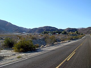
Stovepipe Wells is a small way-station in the northern part of Death Valley, in unincorporated Inyo County, California.

Solar Energy Generating Systems (SEGS) is a concentrated solar power plant in California, United States. With the combined capacity from three separate locations at 354 megawatt (MW), it is the world's second largest solar thermal energy generating facility, after the commissioning of the even larger Ivanpah facility in 2014. It consists of nine solar power plants in California's Mojave Desert, where insolation is among the best available in the United States. SEGS I–II (44 MW) are located at Daggett, SEGS III–VII (150 MW) are installed at Kramer Junction, and SEGS VIII–IX (160 MW) are placed at Harper Lake. NextEra Energy Resources operates and partially owns the plants located at Kramer Junction. On January 26, 2018, the SEGS VIII and IX at Harper Lake were sold to renewable energy company Terra-Gen, LLC. A tenth plant had been in construction and SEGS XI and SEGS XII had been planned by Luz Industries, but the developer filed for bankruptcy in 1992, because it was unable to secure construction financing.
KXFG is a commercial country music radio station in Menifee, California, broadcasting to the south-western sections of the Riverside-San Bernardino, California, area on 92.9 FM. KXFG is a simulcast of KFRG in San Bernardino, California. Its studios are in Colton and the transmitter site for KXFG is in Murrieta.
Panamint Springs is private resort in Inyo County, California. It consists of a motel, cabins, RV and tent campsites, restaurant, and gas station, all operated by Cassell Enterprises, LLC. It lies at an elevation of 1926 feet.
Naval Base Coronado (NBC) is a consolidated Navy installation encompassing eight military facilities stretching from San Clemente Island, located seventy miles west of San Diego, California, to the Mountain Warfare Training Camp Michael Monsoor and Camp Morena, located sixty miles east of San Diego.

RNAS Hatston, also called HMS Sparrowhawk, was a Royal Naval Air Station, one mile to the north west of Kirkwall on the island of Mainland, Orkney, Scotland. It was located near the strategically vital naval base of Scapa Flow, which for most of the twentieth century formed the main base of the ships of the Home Fleet.
The Chino Fault extends along the eastern Chino Hills range region, from Corona in Riverside County to the Los Serranos, Chino Hills area of San Bernardino County in Southern California.
Bradford Siding is a former settlement in Inyo County, California.
Narka is a former settlement in Inyo County, California. It was located on the Southern Pacific Railroad about 3.5 miles (5.6 km) south of the current settlement of Little Lake. Narka began as a railroad camp before Little Lake was settled. A post office operated at Narka from 1909 to 1913, when the service was transferred to Little Lake.
Sodan is a former settlement in Inyo County, California. It was located on the Southern Pacific Railroad about halfway between Narka and Little Lake.
Carthage is a former settlement in Inyo County, California.
Tule Station is a former settlement in Inyo County, California. It was located on the west shore of the Owens Lake 2 miles (3.2 km) south-southeast of Cerro Gordo Landing.
San Jose Township was a defunct township in Los Angeles County, California. It existed prior to the abolition of townships in California, and appeared as a subdivision of Los Angeles County in the 1860, 1870 and 1880 U.S. Censuses. Its area encompassed Rancho San Jose, the eastern portions of the county drained by San Jose Creek, including what is now the cities of Pomona, Claremont and Walnut. In 1880, it was recorded as having 1170 residents - which made it one of the smallest townships in Los Angeles County, but nevertheless a sizable settlement in the region, larger than Bakersfield and slightly smaller than Riverside
References
- 1 2 3 Durham, David L. (1998). California's Geographic Names: A Gazetteer of Historic and Modern Names of the State. Clovis, Calif.: Word Dancer Press. p. 1178. ISBN 1-884995-14-4.
Coordinates: 35°50′31″N117°52′59″W / 35.842°N 117.883°W

| This Inyo County, California-related article is a stub. You can help Wikipedia by expanding it. |