Evelyn, California

Last updated
Evelyn
Unincorporated community
California Locator Map with US.PNG
Red pog.svg
Evelyn
Location in California
Usa edcp location map.svg
Red pog.svg
Evelyn
Evelyn (the US)
Coordinates: 36°08′48″N116°18′58″W / 36.14667°N 116.31611°W / 36.14667; -116.31611 Coordinates: 36°08′48″N116°18′58″W / 36.14667°N 116.31611°W / 36.14667; -116.31611
Country United States
State California
County Inyo County
Elevation [1] 1,880 ft (573 m)

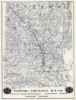
Evelyn is an unincorporated community in Inyo County, California. [1] It is located on the Tonopah and Tidewater Railroad 5 miles (8 km) south-southeast of Eagle Mountain, [2] at an elevation of 1880 feet (573 m). [1]

Unincorporated area Region of land not governed by own local government

In law, an unincorporated area is a region of land that is not governed by a local municipal corporation; similarly an unincorporated community is a settlement that is not governed by its own local municipal corporation, but rather is administered as part of larger administrative divisions, such as a township, parish, borough, county, city, canton, state, province or country. Occasionally, municipalities dissolve or disincorporate, which may happen if they become fiscally insolvent, and services become the responsibility of a higher administration. Widespread unincorporated communities and areas are a distinguishing feature of the United States and Canada. In most other countries of the world, there are either no unincorporated areas at all, or these are very rare; typically remote, outlying, sparsely populated or uninhabited areas.

Inyo County, California County in California, United States

Inyo County is a county in the U.S. state of California. As of the 2010 census, the population was 18,546. The county seat is Independence.

California State of the United States of America

California is a state in the Pacific Region of the United States. With 39.6 million residents, California is the most populous U.S. state and the third-largest by area. The state capital is Sacramento. The Greater Los Angeles Area and the San Francisco Bay Area are the nation's second and fifth most populous urban regions, with 18.7 million and 9.7 million residents respectively. Los Angeles is California's most populous city, and the country's second most populous, after New York City. California also has the nation's most populous county, Los Angeles County, and its largest county by area, San Bernardino County. The City and County of San Francisco is both the country's second-most densely populated major city after New York City and the fifth-most densely populated county, behind only four of the five New York City boroughs.

The place was named in 1907 for Evelyn Kate Smith (née Ellis), wife of Francis Marion Smith of the Pacific Coast Borax Company. [2]

Francis Marion Smith American businessman

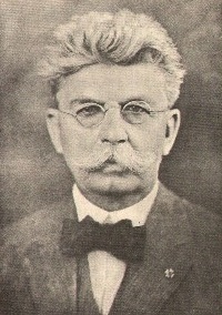
Francis Marion Smith was an American miner, business magnate and civic builder in the Mojave Desert, the San Francisco Bay Area, and Oakland, California.

Pacific Coast Borax Company

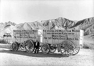
The Pacific Coast Borax Company (PCB) was a United States mining company founded in 1890 by the American borax magnate Francis "Borax" Smith, the "Borax King".

Currently, there are no residents of Evelyn. No structures remain. All that remains is a paved loop of road next to the old railroad grade. The California Department of Transportation uses this area to store paving materials and test equipment for work on California State Route 127 and other area roads.

California Department of Transportation government agency

The California Department of Transportation (Caltrans) is an executive department of the US state of California. The department is part of the cabinet-level California State Transportation Agency (CalSTA). Caltrans is headquartered in Sacramento.

California State Route 127 highway in California

State Route 127 is a California state highway that connects Interstate 15 to Nevada State Route 373, passing near Death Valley National Park. The entire length of the highway closely follows the central portion of the former Tonopah and Tidewater Railroad and loosely follows the Amargosa River.

Related Research Articles

Caliente, California Unincorporated community in California, United States

Caliente is an unincorporated community in Kern County, California. It is located 22 miles (35 km) east-southeast of Bakersfield, at an elevation of 1,312 feet (400 m).

Tonopah and Tidewater Railroad

The Tonopah and Tidewater Railroad was a former class II railroad that ran within the locale of eastern California and southwestern Nevada.

Lost Coast Region of California in the United States

The Lost Coast is a mostly natural and undeveloped area of the California North Coast in Humboldt and Mendocino Counties, which includes the King Range. It was named the "Lost Coast" after the area experienced depopulation in the 1930s. In addition, the steepness and related geotechnical challenges of the coastal mountains made this stretch of coastline too costly for state highway or county road builders to establish routes through the area, leaving it the most undeveloped and remote portion of the California coast. Without any major highways, communities in the Lost Coast region such as Petrolia, Shelter Cove, and Whitethorn are isolated from the rest of California.

Calico Mountains (California) mountains in Mojave Desert of California, United States

The Calico Mountains of California are a mountain range located in the Mojave Desert. The range spans San Bernardino and Inyo counties in California.

Raymond, California Unincorporated community in California, United States

Raymond is an unincorporated community in Madera County, California. It is located 22 miles (35 km) north-northeast of Madera, at an elevation of 948 feet.

Famoso, California Unincorporated community in California, United States

Famoso is an unincorporated community in Kern County, California. It is located on Poso Creek 5.5 miles (8.9 km) south-southeast of McFarland, at an elevation of 427 feet (130 m).

Pulga, California Unincorporated community in California, United States

Pulga is an unincorporated community in Butte County, California. It is located along the west slope of the Feather River canyon, at an elevation of 1398 feet. A variant name for the community is Big Bar. Other nearby communities include Mayaro, Poe and Parkhill. The town hosts a Caltrans highway maintenance station along State Route 70 (SR70). The place is at the mouth of the Flea Valley Creek, which gives rise to the toponym.

Ogilby, California Ghost town in California, United States

Ogilby is a ghost town in Imperial County, California, United States. Ogilby is located on the Southern Pacific Railroad 42 miles (68 km) east of El Centro, and 3.8 miles (6.1 km) north of Interstate 8 on County Road S34. The name is official for federal use, and a feature ID number of 252950 has been assigned. Ogilby is defined by the US Geological Survey as a populated place at 356 feet (109 m) AMSL elevation. NAD27 latitude and longitude are listed at 32°49′01″N114°50′20″W on the "Ogilby, California" 7.5-minute quadrangle (map). It is included in the Imperial County Air Pollution Control District. It lies at an elevation of 364 feet (111 m).

Minturn, California Unincorporated community in California, United States

Minturn is an unincorporated community in Madera County, California. It is located on the Atchison, Topeka and Santa Fe Railroad and California State Route 99 1.5 miles (2 km) north-northwest of Chowchilla, at an elevation of 236 feet. Minturn is near the Geographic Center of California, between Madera and Merced.

Bealville, California Unincorporated community in California, United States

Bealville is an unincorporated community in Kern County, California. It is located on the Union Pacific Railroad 1.25 miles (2 km) south of Caliente, at an elevation of 1,811 feet (552 m).. The area was named after Edward Fitzgerald Beale who owned the adjacent Rancho El Tejon. The Southern Pacific Railroad established the Bealville depot and telegraph office on the railroad in 1876 and it remained in service until 1913.

Meyers, California Unincorporated community in California, United States

Meyers is a small unincorporated community in El Dorado County, California, United States, along U.S. Route 50 in the northern Sierra Nevada mountains 6 miles south of South Lake Tahoe in the Lake Tahoe area. It lies at an elevation of 6,352 feet. Established in 1851, Meyers started out as a stagecoach stop, trading post and Pony Express station. The town is now registered as California Historical Landmark #708. It serves as a popular stop on the way into and out of the Tahoe Basin for travelers on Highways 50 and 89.

Valle Vista, Contra Costa County, California Unincorporated community in California, United States

Valle Vista is a small unincorporated community in Contra Costa County, California, United States. It lies along Canyon Road between Moraga and Canyon. It is also on the Oakland, Antioch and Eastern Railroad 4.5 miles (7.2 km) south-southeast of Orinda, at an elevation of 577 feet. The ZIP Code is 94517 and the community is inside area code 510.

Eastport, California Unincorporated community in California, United States

Eastport is a small unincorporated community in the Berkeley Hills, in southern Contra Costa County, California.

Dresser, California Unincorporated community in California, United States

Dresser is an unincorporated community in Alameda County, California. Its ZIP code is 94536 and its area code is 510.

Shippee, California Unincorporated community in California, United States

Shippee is an unincorporated community in Butte County, California. It lies at an elevation of 131 feet. It is 7.5 miles (12.1 km) west-northwest of Oroville on the Sacramento Northern Railroad and the Northern Electric Railroad.

Latrobe, California Unincorporated community in California, United States

Latrobe is an unincorporated community in El Dorado County, California. It is located 15 miles (24 km) southwest of Placerville, at an elevation of 761 feet.

Smith, California Former settlement in California, United States

Smith is a former settlement in Humboldt County, California. It was located on the Northwestern Pacific Railroad 8.5 miles (14 km) east of Weott, at an elevation of 213 feet. Smith still appeared on maps as of 1949.

Jay is a former settlement in Inyo County, California. It was located on the railroad 3 miles (4.8 km) south of Evelyn.

Soledad Sulphur Springs, California Former settlement in California, United States

Soledad Sulphur Springs is a former settlement in Los Angeles County, California. It lay at an elevation of 1811 feet. Soledad Sulphur Springs still appeared on USGS maps as of 1933. Today, the area is on Sand Canyon Road near the Metrolink Antelope Valley railroad line and California State Route 14 on the outskirts of Santa Clarita. This settlement gave its name to the Sulphur Springs School District.

Rocktram, California unincorporated community in California, United States

Rocktram is an unincorporated community in Napa County, California. It lies at an elevation of 13 feet. Rocktram is located on the Southern Pacific Railroad, 3 miles (4.8 km) south of Napa, at the junction with the Napa Valley Railroad and the Basalt Rock Company rock tram. This area got its name from an overhead tramway between the Basalt Rock Company quarry and a plant located on the Napa River. The tram crossed California State Route 221 near what is now Kaiser Road. Metal containers that hung from a steel cable transported rock from Basalt’s quarry on the hills east of the highway to the plant on the river. The rocks were loaded on barges and floated down to construction sites from Sacramento to San Francisco. Rocks from Basalt were used in the construction of Treasure Island and most of the Bay Area bridges.

References

  1. 1 2 3 U.S. Geological Survey Geographic Names Information System: Evelyn, California
  2. 1 2 Durham, David L. (1998). California's Geographic Names: A Gazetteer of Historic and Modern Names of the State. Clovis, Calif.: Word Dancer Press. p. 1163. ISBN   1-884995-14-4.