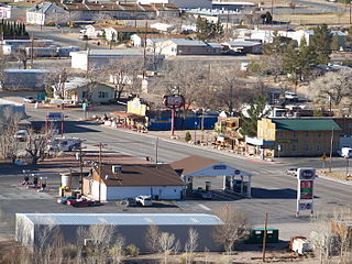
Beatty is an unincorporated town along the Amargosa River in Nye County in the U.S. state of Nevada. U.S. Route 95 runs through the town, which lies between Tonopah, about 90 miles (140 km) to the north and Las Vegas, about 120 miles (190 km) to the southeast. State Route 374 connects Beatty to Death Valley National Park, about 8 miles (13 km) to the west.

Stovepipe Wells is a small way-station in the northern part of Death Valley, in unincorporated Inyo County, California.

The Lackawanna River is a 42-mile-long (68 km) tributary of the Susquehanna River in northeastern Pennsylvania in the United States. It flows through a region of the northern Pocono Mountains that was once a center of anthracite coal mining in the United States. It starts in north Wayne County, Pennsylvania and ends in east Luzerne County, Pennsylvania in Duryea, Pennsylvania. The lower reaches of the river flow through the urban areas of Scranton, which grew around its banks in the 19th century as an industrial center. Its name comes from a Lenni Lenape word meaning "stream that forks".

The Amargosa River is an intermittent waterway, 185 miles (298 km) long, in southern Nevada and eastern California in the United States. It drains a high desert region, the Amargosa Valley in the Amargosa Desert northwest of Las Vegas, into the Mojave Desert, and finally into Death Valley where it disappears into the ground aquifer. Except for a small portion of its route in the Amargosa Canyon in California and a small portion at Beatty, Nevada, the river flows above ground only after a rare rainstorm washes the region. A 26-mile (42 km) stretch of the river between Shoshone and Dumont Dunes is protected as a National Wild and Scenic River. At the south end of Tecopa Valley the Amargosa River Natural Area protects the habitat.

Amargosa Valley is an unincorporated town located on U.S. Route 95 in Nye County, in the U.S. state of Nevada.
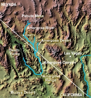
The Amargosa Valley is the valley through which the Amargosa River flows south, in Nye County, southwestern Nevada and Inyo County in the state of California. The south end is alternately called the "Amargosa River Valley'" or the "Tecopa Valley." Its northernmost point is around Beatty, Nevada and southernmost is Tecopa, California, where the Amargosa River enters into the Amargosa Canyon.

Rhyolite is a ghost town in Nye County, in the U.S. state of Nevada. It is in the Bullfrog Hills, about 120 miles (190 km) northwest of Las Vegas, near the eastern boundary of Death Valley National Park. The town began in early 1905 as one of several mining camps that sprang up after a prospecting discovery in the surrounding hills. During an ensuing gold rush, thousands of gold-seekers, developers, miners and service providers flocked to the Bullfrog Mining District. Many settled in Rhyolite, which lay in a sheltered desert basin near the region's biggest producer, the Montgomery Shoshone Mine.

The Amargosa Range is a mountain range in Inyo County, California and Nye County, Nevada. The 110-mile (180 km) range runs along most of the eastern side of California's Death Valley, separating it from Nevada's Amargosa Desert. The U-shaped Amargosa River flows clockwise around the perimeter of the range, ending 279 feet (85 m) below sea level in the Badwater Basin.

Death Valley Junction is a tiny Mojave Desert unincorporated community in Inyo County, California, at the intersection of SR 190 and SR 127, in the Amargosa Valley and just east of Death Valley National Park. The zip code is 92328, the elevation is 2,041 ft (622 m), and the population is fewer than 4.

The Amargosa Desert is located in Nye County in western Nevada, United States, along the California–Nevada border, comprising the northeastern portion of the geographic Amargosa Valley, north of the Ash Meadows National Wildlife Refuge
The Black Mountains are a mountain range located in the southeastern part of Inyo County, California, within southeastern Death Valley National Park.

Leadfield was an unincorporated community, and historic mining town in Inyo County, California. It is now a ghost town. It is located in Titus Canyon in the Grapevine Mountains, east of Death Valley in Death Valley National Park. Leadfield lies at an elevation of 4,058 ft (1,237 m). It is on the National Register of Historic Places.

The Bullfrog Hills are a small mountain range of the Mojave Desert in southern Nye County, southwestern Nevada. Bullfrog Hills was so named from a fancied resemblance of its ore to the color of a bullfrog.

The Salt Spring Hills are a low mountain range in the Mojave Desert, in northern San Bernardino County, California. They are just outside the southeastern corner of Death Valley National Park, southeast of the Saddle Peak Hills. The road between Shoshone and Baker passes through the hills.

Ashford Mill is a former mill in Inyo County, California. It was located in Death Valley, at an elevation of 121 feet below sea level. The place is now protected ruins within Death Valley National Park.

Nitrophila mohavensis is a rare species of flowering plant in the family Amaranthaceae known by the common name Amargosa niterwort. It is endemic to Nye County in southwestern Nevada and Inyo County, in eastern California.

Amargosa Opera House and Hotel is a historic building and cultural center located in Death Valley Junction, in eastern Inyo County, California near Death Valley National Park. Resident artist Marta Becket staged dance and mime shows there from the late 1960s until her final show in February 2012. The Death Valley Junction Historic District is on the National Register of Historic Places and is owned by the nonprofit established by Becket for the preservation of the property.

Leeland is a former railway hamlet in the Amargosa Valley in Nye County, Nevada. A year after its founding in 1906, a railway station was opened. Raw materials from the nearby Californian mining village Lee were brought to Leeland to be transported by train.

Lake Tecopa is a former lake in Inyo County, southern California. It developed during the Miocene and the Pleistocene within a tectonic basin close to the border with Nevada. Fed by the Amargosa River and some neighbouring washes, it eventually culminated to a surface area of 235 square kilometres (91 sq mi) around 186,000 years ago and left sediments. Afterwards, the Amargosa River cut a gorge out of the lake and into Death Valley with its Lake Manly, draining the lake. The present-day towns of Shoshone, California and Tecopa, California lie within the basin of the former lake.


