
The Arctic Archipelago, also known as the Canadian Arctic Archipelago, is a group of islands north of the Canadian mainland.

Cerro Gordo County is a county located in the U.S. state of Iowa. As of the 2010 census, the population was 44,151. Its county seat is Mason City. The county is named for the Battle of Cerro Gordo, which took place during the Mexican–American War.

Keeler, formerly known as Hawley is a census-designated place (CDP) in Inyo County, California, United States. Keeler is located on the east shore of Owens Lake 11.5 miles (19 km) south-southeast of New York Butte, at an elevation of 3602 feet. The population was 66 people at the 2010 census, unchanged from the 2000 census.

Cerro Gordo is a town in Piatt County, Illinois, United States. The population was 1,403 at the 2010 census.

Cerro Gordo is a town in Columbus County, North Carolina, United States. The population was 207 at the 2010 census. According to local legend, the town received its name from a local dignitary, who, upon seeing a fight break out at the dedication of the first railroad depot, exclaimed, "This reminds me of the "Battle of Cerro Gordo".

Owens Lake is a mostly dry lake in the Owens Valley on the eastern side of the Sierra Nevada in Inyo County, California. It is about 5 miles (8.0 km) south of Lone Pine, California. Unlike most dry lakes in the Basin and Range Province that have been dry for thousands of years, Owens held significant water until 1913, when much of the Owens River was diverted into the Los Angeles Aqueduct, causing Owens Lake to desiccate by 1926. Today, some of the flow of the river has been restored, and the lake now contains some water. Nevertheless, as of 2013, it is the largest single source of dust pollution in the United States.
Cerro Gordo may refer to:
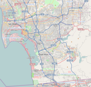
Del Cerro is a wealthy hilly residential neighborhood of approximately 2,300 residents in the eastern part of San Diego, California. Del Cerro borders the communities of San Carlos, Allied Gardens, College Area, Grantville, and the city of La Mesa, and is adjacent to Lake Murray and San Diego State University. For planning purposes the city includes it in the Navajo community planning area.
San Carlos is a neighborhood in the eastern area of San Diego, California. It borders the neighborhoods of Del Cerro, Tierrasanta, and Allied Gardens, the city of La Mesa, and Mission Trails Regional Park. The neighborhood extends to Cowles Mountain at the north.
Navajo is a hilly community in the eastern part of San Diego, California. It is a designated planning area for the city of San Diego. It includes the neighborhoods of Del Cerro, Grantville, San Carlos, and Allied Gardens.

The Cerro Gordo Mines are a collection of abandoned mines located in the Inyo Mountains, near Lone Pine, California in Inyo County, California. Mining operations were undertaken from 1866 until 1957, producing high grade silver, lead, and zinc ore. Some ore was smelted on site, but larger capacity smelters were eventually constructed along the shore of nearby Owens Lake.

Lookout City is a former settlement in the Mojave Desert, in Inyo County, California. It lay at an elevation of 3579 feet.
Bradford Siding is a former settlement in Inyo County, California.
Skyes is a former settlement in Inyo County, California. It was located on the Southern Pacific Railroad 6.5 miles (10 km) north-northwest of Little Lake.
Carthage is a former settlement in Inyo County, California.
Tule Station is a former settlement in Inyo County, California. It was located on the west shore of the Owens Lake 2 miles (3.2 km) south-southeast of Cerro Gordo Landing.

Concord Township is one of sixteen townships in Hancock County, Iowa, USA. At the 2000 census, its population was 3,246.
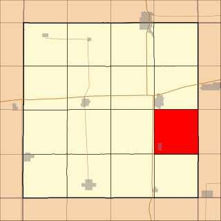
Ell Township is one of sixteen townships in Hancock County, Iowa, USA. As of the 2000 census, its population was 870.

Ellington Township is one of sixteen townships in Hancock County, Iowa, USA. As of the 2000 census, its population was 550.


