Adona, Arkansas

Last updated

Adona, Arkansas
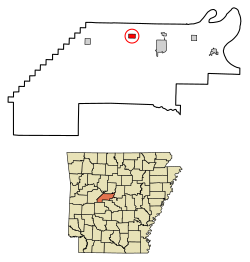
Perry County Arkansas Incorporated and Unincorporated areas Adona Highlighted 0500250.svg
Location of Adona in Perry County, Arkansas.
Coordinates: 35°2′22″N92°53′56″W / 35.03944°N 92.89889°W / 35.03944; -92.89889
Country United States
State Arkansas
County Perry
Area
[1]
  Total0.95 sq mi (2.46 km2)
  Land0.95 sq mi (2.46 km2)
  Water0.00 sq mi (0.00 km2)
Elevation
[2]
371 ft (113 m)
Population
 (2020)
  Total149
  Density157.01/sq mi (60.61/km2)
Time zone UTC-6 (Central (CST))
  Summer (DST) UTC-5 (CDT)
ZIP code
72001
Area code 501
FIPS code 05-00250
GNIS feature ID2403065 [2]

Adona is a city [3] in Perry County, Arkansas, United States. The population was 209 at the 2010 census.

Contents

Geography

Adona is located at 35°2′22″N92°53′56″W / 35.03944°N 92.89889°W / 35.03944; -92.89889 (35.039554, -92.898772). [4]

According to the United States Census Bureau, the town has a total area of 2.4 km2 (0.9 mi2), all land.

Demographics

Historical population
CensusPop.Note
1920 241
1930 200−17.0%
1940 2189.0%
1950 194−11.0%
1960 154−20.6%
1970 20432.5%
1980 23012.7%
1990 146−36.5%
2000 18728.1%
2010 20911.8%
2020 149−28.7%
U.S. Decennial Census [5]

Adona is part of the Little Rock North Little Rock Conway Metropolitan Statistical Area.

2000 census

At the 2000 census, [6] there were 187 people, 76 households and 58 families residing in the town. The population density was 76.8/km2 (198.1/mi2). There were 82 housing units at an average density of 33.7/km2 (86.9/mi2). The racial makeup of the town was 94.12% White, 3.21% Black or African American, 2.14% Native American, and 0.53% from two or more races.

There were 76 households, of which 32.9% had children under the age of 18 living with them, 59.2% were married couples living together, 15.8% had a female householder with no husband present, and 22.4% were non-families. 19.7% of all households were made up of individuals, and 10.5% had someone living alone who was 65 years of age or older. The average household size was 2.46 and the average family size was 2.81.

Age distribution was 24.6% under the age of 18, 5.3% from 18 to 24, 30.5% from 25 to 44, 18.2% from 45 to 64, and 21.4% who were 65 years of age or older. The median age was 37 years. For every 100 females, there were 92.8 males. For every 100 females age 18 and over, there were 93.2 males.

The median household income was $34,375, and the median family income was $38,333. Males had a median income of $29,583 versus $20,000 for females. The per capita income for the town was $30,247. About 11.1% of families and 9.9% of the population were below the poverty line, including 10.0% of those under the age of eighteen and 7.7% of those 65 or over.
Education

Early childhood, elementary and secondary school students primarily attend Perryville School District, [7] which leads to graduation from Perryville High School.

Related Research Articles

<span class="mw-page-title-main">Perry County, Arkansas</span> County in Arkansas, United States

Perry County is a county located in the U.S. state of Arkansas. Its population was 10,019 at the 2020 United States Census. The county seat is Perryville. The county was formed on December 18, 1840, and named for Commodore Oliver Hazard Perry, naval hero in the War of 1812. It is an alcohol prohibition or dry county.

<span class="mw-page-title-main">Briarcliff, Arkansas</span> City in Arkansas, United States

Briarcliff is a second-class city in Baxter County, Arkansas, United States. The population was 236 at the 2010 census.

<span class="mw-page-title-main">Oak Grove, Carroll County, Arkansas</span> Town in Arkansas, United States

Oak Grove is a town in Carroll County, Arkansas, United States. The population was 386 at the 2020 census.

<span class="mw-page-title-main">Anthonyville, Arkansas</span> Town in Arkansas, United States

Anthonyville is a town in Crittenden County, Arkansas, United States. The population was 161 at the 2010 census, down from 250 in 2000.

<span class="mw-page-title-main">Jericho, Arkansas</span> Town in Arkansas, United States

Jericho is a town in Crittenden County, Arkansas, United States. The population was 119 at the 2010 census, down from 184 in 2000.

<span class="mw-page-title-main">Mount Vernon, Arkansas</span> City in Arkansas, United States

Mount Vernon is a town in Faulkner County, Arkansas, United States. The population was 145 at the 2010 census. It is part of the Central Arkansas region.

<span class="mw-page-title-main">Perla, Arkansas</span> Town in Arkansas, United States

Perla is a town in Hot Spring County, Arkansas, United States. The population was 241 at the 2010 census, up from 115 at the 2000 census. The city's water association filed for Chapter 9 Bankruptcy in the Western District of Arkansas Bankruptcy Court on May 26, 2019.

<span class="mw-page-title-main">Grubbs, Arkansas</span> City in Arkansas, United States

Grubbs is a city in Jackson County, Arkansas, United States. The population was 386 at the 2010 census.

<span class="mw-page-title-main">Minturn, Arkansas</span> Town in Arkansas, United States

Minturn is a town in Lawrence County, Arkansas, United States. The population was 109 at the 2010 census.

<span class="mw-page-title-main">Caulksville, Arkansas</span> Town in Arkansas, United States

Caulksville is a town in Logan County, Arkansas, United States. The population was 213 at the 2010 census.

<span class="mw-page-title-main">Cale, Arkansas</span> Town in Arkansas, United States

Cale is a town in Nevada County, Arkansas, United States. The population was 75 at the 2000 census. It is part of the Hope Micropolitan Statistical Area.

<span class="mw-page-title-main">Western Grove, Arkansas</span> Town in Arkansas, United States

Western Grove is a town in northeastern Newton County, Arkansas, United States. The population was 384 at the 2010 census. It is part of the Harrison Micropolitan Statistical Area.

<span class="mw-page-title-main">Louann, Arkansas</span> Town in Arkansas, United States

Louann is a town in Ouachita County, Arkansas, United States. The population was 195 at the 2000 census, which fell to 164 in the 2010 census. It is part of the Camden Micropolitan Statistical Area.

<span class="mw-page-title-main">Bigelow, Arkansas</span> Town in Arkansas, United States

Bigelow is a town in Perry County, Arkansas, United States. Located in Central Arkansas near the confluence of the Fourche La Fave River and Arkansas River, the community was incorporated in 1905 as Esau. Based largely on the timber industry, the town grew until the lumber mills were closed in 1920. The population was 329 at the 2000 census.

<span class="mw-page-title-main">Perryville, Arkansas</span> City in Arkansas, United States

Perryville is a city in and the county seat of Perry County, Arkansas, United States. The population was 1,460 at the 2010 census, an increase of just two persons from 2000. It is part of the Little Rock–North Little Rock–Conway Metropolitan Statistical Area.

<span class="mw-page-title-main">Traskwood, Arkansas</span> City in Arkansas, United States

Traskwood is a city in Saline County, Arkansas, United States. The population was 518 at the 2010 census. It is part of the Little Rock–North Little Rock–Conway Metropolitan Statistical Area.

<span class="mw-page-title-main">Bonanza, Arkansas</span> City in Arkansas, United States

Bonanza is a city in Sebastian County, Arkansas, United States. It is part of the Fort Smith, Arkansas-Oklahoma Metropolitan Statistical Area. At the 2010 Census, the population of Bonanza was 575. According to the 2018 US Census Bureau estimates, the population of Bonanza was 564. Bonanza began as a coal mining town of the Central Coal and Coke company.

<span class="mw-page-title-main">Caldwell, Arkansas</span> Town in Arkansas, United States

Caldwell is a town in St. Francis County, Arkansas, United States. The population was 555 at the 2010 census, an increase from 465 in 2000.

<span class="mw-page-title-main">Griffithville, Arkansas</span> Town in Arkansas, United States

Griffithville is a town in White County, Arkansas, United States. Windle Porter is the current mayor. The population was 262 at the 2000 census.

<span class="mw-page-title-main">Orleans (CDP), Massachusetts</span> Census-designated place in Massachusetts, United States

Orleans is a census-designated place (CDP) in the town of Orleans in Barnstable County, Massachusetts, United States. The population was 1,621 at the 2010 census.

References

  1. "2020 U.S. Gazetteer Files". United States Census Bureau. Retrieved October 29, 2021.
  2. 1 2 U.S. Geological Survey Geographic Names Information System: Adona, Arkansas
  3. Local.Arkansas.gov - Adona , retrieved September 3, 2012
  4. "US Gazetteer files: 2010, 2000, and 1990". United States Census Bureau. February 12, 2011. Retrieved April 23, 2011.
  5. "Census of Population and Housing". Census.gov. Retrieved June 4, 2015.
  6. "U.S. Census website". United States Census Bureau . Retrieved January 31, 2008.
  7. "2020 CENSUS - SCHOOL DISTRICT REFERENCE MAP: Perry County, AR" (PDF). U.S. Census Bureau . Retrieved October 16, 2022.