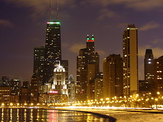
The John Hancock Center is a 100-story, 1,128-foot supertall skyscraper located in Chicago, Illinois. Located in the Magnificent Mile district, its name was changed to 875 North Michigan Avenue on February 12, 2018.

The Loop, one of Chicago's 77 designated community areas, is the central business district in the downtown area of the city. It is home to Chicago's commercial core, City Hall, and the seat of Cook County. Bounded on the north and west by the Chicago River, on the east by Lake Michigan, and on the south by Roosevelt Road, it is the second largest commercial business district in the United States after Midtown Manhattan and contains the headquarters of many locally and globally important businesses as well as many of Chicago's most famous attractions.

Lake View, also spelled Lakeview, is one of the 77 community areas of Chicago, Illinois, located on the city's North Side. It is bordered by West Diversey Parkway on the south, West Irving Park Road on the north, North Ravenswood Avenue on the west, and the shore of Lake Michigan on the east. The Uptown community area is to Lakeview's north, Lincoln Square to its northwest, North Center to its west and Lincoln Park to its south. The 2016 population of Lakeview was 99,876 residents, making it the largest of the Chicago community areas by population.

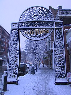
Corktown is a historic district located just west of Downtown Detroit, Michigan. It is the oldest extant neighborhood in the city. The current boundaries of the district include I-75 to the north, the Lodge Freeway to the east, Bagley and Porter streets to the south, and Rosa Parks Boulevard to the west. The neighborhood was listed on the National Register of Historic Places in 1978.

Streeterville is a neighborhood in the Near North Side community area of Chicago, Illinois, United States, north of the Chicago River. It is bounded by the river on the south, the Magnificent Mile portion of Michigan Avenue on the west, and Lake Michigan on the north and east, according to most sources, although the City of Chicago only recognizes a small portion of this region as Streeterville. Thus, it can be described as the Magnificent Mile plus all land east of it. The tourist attraction of Navy Pier extends out into the lake from southern Streeterville. The majority of the land in this neighborhood is reclaimed sandbar.

The Near South Side is a community area of Chicago, Illinois, United States, just south of the downtown central business district, the Loop. The Near South Side's boundaries are as follows: North—Roosevelt Road ; South—26th Street; West—Chicago River between Roosevelt and 18th Street, Clark Street between 18th Street and Cermak Road, Federal between Cermak Road and the Stevenson Expressway just south of 25th Street, and Clark Street again between the Stevenson and 26th Street; and East—Lake Michigan.

Lower West Side is a community area on the West Side of Chicago, Illinois, United States. It is three miles southwest of the Chicago Loop and its main neighborhood is Pilsen. The Heart of Chicago is a neighborhood in the southwest corner of the Lower West Side.

The Magnificent Mile, sometimes referred to as The Mag Mile, is an upscale section of Chicago's Michigan Avenue, running from the Chicago River to Oak Street in the Near North Side. The district is located adjacent to downtown, and one block east of Rush Street. The Magnificent Mile serves as the main thoroughfare between Chicago's Loop business district and its Gold Coast. It is generally the western boundary of the Streeterville neighborhood, to its east and River North to the west.
Old Town is a neighborhood and historic district in North Side, Chicago, Illinois, home to many of Chicago's older, Victorian-era buildings, including St. Michael's Church, one of seven buildings to survive the Great Chicago Fire.

The Gage Group Buildings consist of three buildings located at 18, 24 and 30 S. Michigan Avenue, between Madison Street and Monroe Street, in Chicago, Illinois. They were built from 1890–1899, designed by Holabird & Roche for the three millinery firms - Gage, Keith and Ascher. The building at 18 S. Michigan Avenue has an ornamental façade designed by Louis Sullivan. It was listed on the National Register of Historic Places on November 14, 1985, and was designated a Chicago Landmark on September 11, 1996. In addition, it is a historic district contributing property for the Chicago Landmark Historic Michigan Boulevard District.

The Brush Park Historic District, frequently referred to as simply Brush Park, is a 22-block neighborhood located within Midtown Detroit, Michigan and designated by the city. It is bounded by Mack Avenue on the north, Woodward Avenue on the west, Beaubien Street on the east, and the Fisher Freeway on the south. The Woodward East Historic District, a smaller historic district completely encompassed by the larger Brush Park neighborhood, is located on Alfred, Edmund, and Watson Streets, from Brush Street to John R. Street, and is recognized by the National Register of Historic Places.

Pullman National Monument, also known as The Pullman District and Pullman Historic District, is located in Chicago and was the first model, planned industrial community in the United States. The district had its origins in the manufacturing plans and organization of the Pullman Company, and became one of the most famous company towns in the United States, as well as the scene of the violent 1894 Pullman strike. It was built for George Pullman as a place to produce the famous Pullman sleeping cars.

The Historic Michigan Boulevard District is a historic district in the Loop community area of Chicago in Cook County, Illinois, United States encompassing Michigan Avenue between 11th or Roosevelt Road, depending on the source, and Randolph Streets and named after the nearby Lake Michigan. It was designated a Chicago Landmark on February 27, 2002. The district includes numerous significant buildings on Michigan Avenue facing Grant Park. In addition, this section of Michigan Avenue includes the point recognized as the end of U.S. Route 66. This district is one of the world's best known one-sided streets rivalling Fifth Avenue in New York City and Edinburgh's Princes Street. It lies immediately south of the Michigan–Wacker Historic District and east of the Loop Retail Historic District.

The Chicago Avenue Pumping Station is a historic district contributing property in the Old Chicago Water Tower District landmark district. It is located on Michigan Avenue along the Magnificent Mile shopping district in the Near North Side community area of Chicago, Illinois. It is on the east side of Michigan Avenue opposite the Chicago Water Tower.

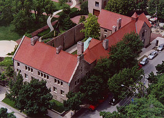
The Henry B. Clarke House is a Greek Revival style house in Chicago, Illinois, United States. Henry Brown Clarke was a native of New York State who had come to Chicago in 1833 with his wife, Caroline Palmer Clarke, and his family. He entered into the hardware business with William Jones and Byram King, establishing King, Jones and Company, and provided building materials to the growing Chicago populace. The house was built in circa 1836 by a local contractor, probably John Rye, who later married the Clarkes' housemaid, Betsy.

The Boston–Edison Historic District is a historic neighborhood located in the geographic center of Detroit, Michigan. It consists of over 900 homes built on four east/west streets: West Boston Boulevard, Chicago Boulevard, Longfellow Avenue, and Edison Avenue, stretching from Woodward Avenue on the east to Linwood Avenue on the west. It is one of the largest residential historic districts in the nation. It is surrounded by Sacred Heart Major Seminary to the west, the Arden Park-East Boston Historic District and the Cathedral of the Most Blessed Sacrament to the east, and the Atkinson Avenue Historic District to the south. The district was designated a Michigan State Historic Site in 1973 and listed on the National Register of Historic Places in 1975.

Michigan Boulevard Garden Apartments is a large apartment building located in the Bronzeville neighborhood of the South Side of Chicago, Illinois. It is located at East 47th Street and South Michigan Avenue, just one block east of the former Chicago Housing Authority's Robert Taylor Homes site. In total, the building is made up of 421 apartments, a large landscaped courtyard, and retail space at street level. It was originally built as non-governmental subsidized housing and is considered to be among the earliest mixed-use housing developments.
Prairie Avenue is a north–south street on the South Side of Chicago, which historically extended from 16th Street in the Near South Side community area of Chicago in Cook County, Illinois, United States, to the city's southern limits and beyond. The street has a rich history from its origins as a major trail for horseback riders and carriages. During the last three decades of the 19th century, a six-block section of the street served as the residence of many of Chicago's elite families and an additional four-block section was also known for grand homes. The upper six-block section includes part of the historic Prairie Avenue District, which was declared a Chicago Landmark and added to the National Register of Historic Places.

The historic Chicago park and boulevard system is a ring of parks connected by wide, planted-median boulevards that winds through the north, west, and south sides of the City of Chicago. The neighborhoods along this historic stretch include, Logan Square, Humboldt Park, Englewood, Back of the Yards, Lawndale, and Bronzeville. It reaches as far west as Garfield Park and turns south east to Douglas Park. In the south, it reaches Washington Park and Jackson Park, including the Midway Plaisance, used for the 1893 World's Fair.