Anchorage Trail Systems

Last updated

The trail system of Anchorage, Alaska spans 578 miles (930.2km). [1] The Municipality of Anchorage created the first set of trail systems for recreation in the late 1950s, not developing a system that was commuter friendly until the mid 1960s. [2] The trails, which are used primarily for recreation and commuter traffic, are heavily utilized year round for walking, biking, and skiing. Many of the trail systems in place that connect the city of Anchorage in a commuter-friendly way were kick started by John "Jack" Roderick, the first mayor of the Municipality of Anchorage, who held office from 1972-1975. [3]

Contents

The Anchorage Trail Systems run through many local and state parks. The largest park that hosts a variety of trails is Chugach State Park. An innumerable number of trails cover this large area of land that stretches upwards of 495,000 acres (200,319 ha). [4] The trail systems connect the greater Anchorage Bowl, the coastlines of Cook Inlet and Turnagain Arm, and the Chugach Mountain Range in Chugach State Park.

A sunny and groomed ski trail on the Lighted Loop Trail in Far North Bicentennial Park Far North Bicentennial Park.jpg
A sunny and groomed ski trail on the Lighted Loop Trail in Far North Bicentennial Park

Many trails in Anchorage are named in honor of individuals that made important contributions in the Anchorage community to an Anchorage trail system directly, or a person who had great success with a recreation/sport associated with the uses of the trail systems.

History

A view from Chester Creek Trail overlooking Westchester Lagoon Weschester Lagoon .jpg
A view from Chester Creek Trail overlooking Westchester Lagoon

The Municipality of Anchorage was created in 1972. The State of Alaska became a state only a few decades earlier in the year 1959, shortly after President Eisenhower signed the Alaska Statehood Act. The first trails, constructed in the late 1950s, were developed by local people with private interests in recreation or transport. Municipality funding did not feed into the construction of these trails until the late 1960s. [5] Paths in some of the original areas of the municipality linked neighborhoods and roadways but were used in a utilitarian manner rather than for sport. Anchorage trails are maintained by the State Park Service, Parks and Recreation, [6] the Municipality of Anchorage, [7] and private action groups who serve multiple user groups like skiers or bikers.

The Nordic Skiing Association of Anchorage (NSAA) [8] was founded in the early 1960s when Nordic Skiing took Anchorage by storm. [8] NSAA's contributions to the trail systems in Anchorage have been instrumental in creating well-kept areas for individuals to use in both winter and summer months. [8] In 1976 the Municipality began to fund ski grooming on multi-use trail systems in the city. However, in 1983 a tax cap was initiated by local government and with that the onset of more private funding by local donors for ski grooming on ski-only trails began. NSAA (and many other trail advocate groups in Anchorage) are able to maintain trails year-round by private sponsorship, donations, and membership dues. [8]

In more recent years, local action groups in Anchorage such as the Anchorage Park Foundation, Bike Anchorage and Single Track Advocates have come onto the scene and greatly developed trail networks in Anchorage for recreational uses. Single Track Advocates is a group that has catered its efforts primarily to mountain biking and an indirect result, trail running. [9] One of the many things Bike Anchorage has done in Anchorage is strive for an increase of commuter-friendly and bike-friendly options in Anchorage. [10] Since 2011, Single Track Advocates has added 16 miles of single track trails to Kincaid Park and 4.5 miles of mountain bike trials in Hillside Park. [9] Both of these groups are a small portion of the many privately funded groups in Anchorage that contribute to the upkeep and advocacy for Anchorage trails that lie outside of the Parks and Recreation and Municipal departments. The Municipality of Anchorage has an Adopt-A-Trail program where monetary and time donations are accepted. Different portions of trails around the city are divided and adopted by local groups, companies, or individuals to help maintain the trails. The adopters of the trail earn their name posted with an Adopt-A-Trail sign as a form of advertisement for the group that "adopted" the trail. [11] The initiative has experienced great success in creating a community that actively engages with trail maintenance out of private action groups or tax funded efforts. [11]

Recreational uses

Fireweed lines a foggy hiking path near the Glenn Alps Trail Head in Chugach State Park Fireweed in Glenn Alps.jpg
Fireweed lines a foggy hiking path near the Glenn Alps Trail Head in Chugach State Park

Anchorage Trails offer a multitude of year-round opportunities for recreation and sports.

Some of the activities that the trails host include Nordic skiing, hiking, trail and road running, walking, mountain biking, road biking, horseback riding, ski jouring, snowshoeing, rollerblading, and connections to innumerable parks, lakes, rivers and beaches that offer opportunities for fishing, water sports, and activities such as iceskating and ice fishing in the winter months.

Organized sport groups that are involved with various sports offer a great advantage to the conscious use of Anchorage's trails and their upkeep. The continuous improvement and expansion of Anchorage trails are largely motivated by sport groups, the main reason being that the maintenance of local trails are instrumental to the success of these organizations. [10] [8] [9] Teams and sport groups in Anchorage range from youth programs such as Mighty Bikes, a non-profit mountain bike organization, to collegiate and professional sport individuals or teams that use the trails year round. Anchorage entertains a large base of professional and collegiate athletes that train on the trails independently or with groups such as the University of Alaska Anchorage and Alaska Pacific University. [12] [13] [14] [15]

Commuter uses

Outside of sports and recreation, Anchorage is a city that has developed into a more commuter friendly city in recent years for individuals on foot or on a bike. [6] Because of the layout of the city, Anchorage has faced many challenges to create a system of trail networks that not only provide connections to the entire area but a system that also provides safety for its users. [16] In conjunction with trails- sparse bike lanes, wide road shoulders, and sidewalks that are plowed semi-regularly during the winter months are utilized by commuter traffic. Many neighborhoods in Anchorage are connected by means of the trail systems. [17] Jack Roderick, [18] Anchorage's mayor from 1972-1975, was the first local government official to recognize that Anchorage needed to become a place that could provide commuter options for individuals who did not own a car. [19] Since his actions to develop the trail systems in that regard were started, Anchorage has slowly plugged away at evolving their trails to serve not only the recreational user but also the commuter. Some examples of this are demonstrated by the Anchorage Bicycle Plan or the recent addition of Moose Loop, [20] a trail that connects the greater Anchorage Bowl. The 32-mile loop not only opened up a great deal of new options for commuters to stay off the busy roads, but also provided for individuals wishing to see Anchorage in a non-commuter setting. [20]

Anchorage locals enjoy a scenic bike ride through the Lynn Ary Park corridor of the Tony Knowles Coastal Trail Biking the Coastal Trail .jpg
Anchorage locals enjoy a scenic bike ride through the Lynn Ary Park corridor of the Tony Knowles Coastal Trail

Tony Knowles Coastal Trail is a highly trafficked trail that runs along Cook Inlet. The trail is named after Tony Knowles, Anchorage's governor from 1994 to 2002. [21] While the trail runs along Cook Inlet, it also connects its users to places such as Westchester Lagoon and has also been included as a part of the recently completed Moose Loop. [20] The Chester Creek trails, Campbell Creek trailheads, Earthquake Park, [22] Point Woronzof, and various neighborhoods such as Turnagain and Fairview are included in these new connections as well.

Far North Bicentennial Park is an area that covers an expansive area of the Chugach foothills as well as a connection to areas such as Chugach State Park, Moose Loop, Campbell Creek Science Center, Hilltop Ski Area, and the Tour Trail of Anchorage. The park covers over 100 miles of land and offers countless trails. [23]

Kincaid Park is another hub that connects with Cook Inlet, Moose Loop, and the Coastal Trail. Kincaid park has hosted national sport events [24] [25] and local events ranging from activities such as weddings, cross country running meets, frolf tournaments, and state soccer championships. [25] The trails that run around the area are home to a dense moose and bear population. [24]

Safety and statistics

Infographics line Anchorage trails all over the city to inform its users of traffic flow, safety information, and often fun facts about the area and its history. Trail Signs on at Campbell Trailhead .jpg
Infographics line Anchorage trails all over the city to inform its users of traffic flow, safety information, and often fun facts about the area and its history.

Anchorage Trail Systems require certain precautions to ensure the safety and enjoyment of all of its users. Trail etiquette and trail flow charts are frequently posted to inform users of what trails can be used for which activities as well as how one should yield to other users depending on the activity they are practicing. Anchorage is home to a variety of wildlife that can be dangerous. Users of the trails should be aware of how to proceed if they encounter moose or bears. Bear spray, bells, awareness of one's surroundings, reflective wear, appropriate gear for the activity you are practicing, and not wearing headphones are ways that one can help ensure their safety. [7]

The Municipality of Anchorage lists the following statistics for the trail systems:

120 miles (195 km) paved trail systems (multi-use)

105 miles (175km) groomed ski trails

103 mies (216 km) plowed winter walkways

36 miles (60 km) dog mushing trails

87 miles (145 km) summer non-paved trails

24 miles (40 km) lighted ski trails

66 km ski jor trails

10 km exclusively equestrian trails

Chugach State Park: 495,000 acres.

These statistics roughly represent the paved pathways in Anchorage but do not take into account possible commuter routes that are not official trail systems. [1]

Related Research Articles

<span class="mw-page-title-main">Seward Highway</span> State highway in Alaska, United States

The Seward Highway is a highway in the U.S. state of Alaska that extends 125 miles (201 km) from Seward to Anchorage. It was completed in 1951 and runs through the scenic Kenai Peninsula, Chugach National Forest, Turnagain Arm, and Kenai Mountains. The Seward Highway is numbered Alaska Route 9 (AK-9) for the first 37 miles (60 km) from Seward to the Sterling Highway and AK-1 for the remaining distance to Anchorage. At the junction with the Sterling Highway, AK-1 turns west towards Sterling and Homer. About eight miles (13 km) of the Seward Highway leading into Anchorage is built to freeway standards. In Anchorage, the Seward Highway terminates at an intersection with 5th Avenue, which AK-1 is routed to, and which then leads to the Glenn Highway freeway.

<span class="mw-page-title-main">Flattop Mountain (Anchorage, Alaska)</span>

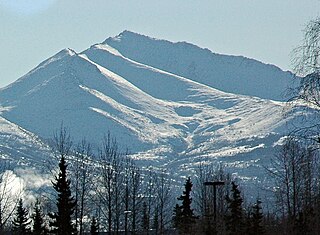
Flattop Mountain is a 3,510 feet (1,070 m) mountain in the U.S. state of Alaska, located in Chugach State Park just east of urban Anchorage. It is the most climbed mountain in the state.

<span class="mw-page-title-main">Eagle River, Anchorage</span> Community in Alaska, USA

Eagle River is a community within the Municipality of Anchorage situated on the Eagle River, for which it is named, between Joint Base Elmendorf-Richardson and Chugach State Park in the Chugach Mountains. Its ZIP code is 99577. Settled by homesteaders, Eagle River has been annexed to the Municipality of Anchorage since the 1970s—a relationship that is, at times, complicated. On the one hand, Eagle River functions as an Anchorage suburb, with a number of Eagle River residents working in, shopping or participating in community life in the Anchorage bowl. Much of the community is also made up of residents from nearby Joint Base Elmendorf-Richardson. On the other hand, the community is itself a significant business hub between Wasilla and Anchorage, offering shopping, restaurants, recreation and employment. Secession efforts have from time to time gained traction by residents who would like Eagle River legally regarded as a separate community. Eagle River also has a close relationship with its neighboring community to the north, Chugiak, with which it shares some history. If Eagle River were not part of the Municipality of Anchorage, it would be classified as one of the five largest cities in Alaska.

<span class="mw-page-title-main">Chugach National Forest</span> National Forest in Alaska, United States

The Chugach National Forest is a 6,908,540-acre (27,958 km2) United States National Forest in south central Alaska. Covering portions of Prince William Sound, the Kenai Peninsula and the Copper River Delta, it was formed in 1907 from part of a larger forest reserve. The Chugach includes extensive shorelines, glaciers, forests and rivers, much of which is untouched by roads or trails. It hosts numerous bird, mammal and marine species, including extensive shorebird habitat and a bald eagle population larger than the contiguous 48 states combined. Human industry in the forest includes extensive tourism and some mining and oil and gas operations.

<span class="mw-page-title-main">Chugach State Park</span> State park in Alaska, United States

Chugach State Park covers 495,204 acres covering a hilly region immediately east of Anchorage, in south-central Alaska.

<span class="mw-page-title-main">Hatcher Pass</span>

Hatcher Pass is a mountain pass through the southwest part of the Talkeetna Mountains, Alaska. It is named after Robert Hatcher, a prospector and miner. The nearest cities are Palmer and Wasilla approximately 12 miles (19 km) to the south, and Willow approximately 26 mi (42 km) to the west. The communities are at an elevation of approximately 250 ft (76 m) in the Mat-Su valley.

<span class="mw-page-title-main">Hilltop Ski Area</span> Ski area in Alaska, United States

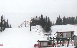
Hilltop Ski Area is a ski area in Anchorage, Alaska established in 1984. Located in Far North Bicentennial Park near Chugach State Park at the base of the Chugach Mountains, Hilltop Ski Area is owned and operated by Youth Exploring Adventure, Inc., an Anchorage nonprofit 501(c)(3) organization established in 1979 to provide recreational programs for Anchorage youth.

<span class="mw-page-title-main">Anchorage, Alaska</span> Consolidated city-borough in Alaska, United States

The Municipality of Anchorage is the largest city in the U.S. state of Alaska by population. With a population of 291,247 at the 2020 census, it contains nearly 40% of the state's population. The Anchorage metropolitan area, which includes Anchorage and the neighboring Matanuska-Susitna Borough, had a population of 398,328 in 2020, accounting for more than half the state's population. At 1,706 sq mi (4,420 km2) of land area, the city is the fourth-largest by area in the United States and larger than the smallest state, Rhode Island, which has 1,212 sq mi (3,140 km2).

<span class="mw-page-title-main">Kincaid Park</span> Municipal park in Anchorage, Alaska

Kincaid Park is a 1,516.78-acre (6.1382 km2) municipal park in Anchorage, Alaska, located at 9401 W. Raspberry Road. The park is bounded on the south by Turnagain Arm, on the west by Knik Arm, and on the north by Ted Stevens Anchorage International Airport. Noted for Nordic skiing trails, in snowless months the park is frequented by runners, bikers, hikers, archers, dog-trainers, motocross users, disc golfers, soccer teams, and rollerskiers. Other winter activities include snowshoeing, sledding and biathlon. The park was created in 1978 and later expanded to include the location of a deactivated former Nike missile site. The park continues to evolve with changing demands of local residents. In 2009, a full 18 "hole" disc golf course that meanders through the wooded Mize Loop area was completed. In 2010, several new soccer fields were completed and open for use in the area near the chalet. In 2012, a single artificial turf soccer field with stadium seating was completed just south of the park's headquarters building, Kincaid Chalet. Cook Inlet, Fire Island with its wind turbines, and Mount Susitna are visible from most hilltops in the park. On a clear day, Denali can also be seen from the park.

Point Woronzof Park is a municipal park in Anchorage, Alaska known for its views of Denali. The park is excellent for backcountry skiing or snowshoeing in the winter, and biking or running in the summer.

The following is a list of sporting venues, events, and teams based in Alaska.

<span class="mw-page-title-main">Tony Knowles Coastal Trail</span>

Template:Off more citations needed

<span class="mw-page-title-main">Eagle River (Cook Inlet)</span> River in Alaska, United States

The Eagle River is a stream, 40 miles (64 km) long, in Anchorage, Alaska. Heading at Eagle Glacier in Chugach State Park, it flows northwest into Eagle Bay on the Knik Arm of Cook Inlet, 9 miles (14 km) northeast of downtown Anchorage.

<span class="mw-page-title-main">Chester Creek (Alaska)</span> River in Alaska, United States

Chester Creek is one of several streams that flow through the city of Anchorage, Alaska. It runs for 21 miles (34 km) from the Chugach Mountains to the Knik Arm of Cook Inlet.

<span class="mw-page-title-main">Indian, Anchorage</span> Unincorporated community in the state of Alaska, United States

Indian is a community in the Municipality of Anchorage, Alaska, United States. It lies in a valley in the Chugach Mountains near the middle of the north shore of the Turnagain Arm of Cook Inlet. It is about 24 miles (39 km) southeast of downtown Anchorage and about 3 miles (4.8 km) northwest of Bird, and about 13 miles (21 km) west-northwest of Girdwood.

<span class="mw-page-title-main">Summit Lake (Chugach National Forest)</span> Lake in the state of Alaska, United States

Summit Lake is located on Canyon Creek in the Chugach National Forest, Alaska, United States and is situated along the Seward Highway (AK-1) 10 miles (16 km) north-northeast of Moose Pass and about 23 miles (37 km) southwest of the Portage area of Anchorage. The lake is fed by Canyon Creek from the southwest and Tenderfoot Creek from the east. The lake empties into Canyon Creek on the northeast, which flows through Lower Summit Lake, into Six Mile Creek, and eventually into the Turnagain Arm of the Cook Inlet.

<span class="mw-page-title-main">Eklutna Lake</span> Reservoir in Alaska, U.S.

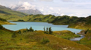
Eklutna Lake is a 1,424.5 hectares lake in the Municipality of Anchorage, Alaska, near the village of Eklutna. It is located entirely inside Chugach State Park and is about 1 mile (1.6 km) wide and 7 miles (11 km) in length.

The Far North Bicentennial Park is the largest park in Anchorage, in U.S. state of Alaska, and has over 1 million annual visitors. The park contains the Hilltop Ski Area, the Alaska Botanical Garden, over 100 miles of multi-use trails, and access to Chugach State Park.

<span class="mw-page-title-main">Trails in Minneapolis</span>

Minneapolis is often considered one of the top biking and walking cities in the United States due to its vast network of trails and dedicated pedestrian areas. In 2020, Walk Score rated Minneapolis as 13th highest among cities over 200,000 people. Some bicycling ratings list Minneapolis at the top of all United States cities, while others list Minneapolis in the top ten. There are over 80 miles (130 km) of paved, protected pathways in Minneapolis for use as transportation and recreation. The city's Grand Rounds National Scenic Byway parkway system accounts for the vast majority of the city's shared-use paths at approximately 50 miles (80 km) of dedicated biking and walking areas. By 2008, other city, county, and park board areas accounted for approximately 30 miles (48 km) of additional trails, for a city-wide total of approximately 80 miles (130 km) of protected pathways. The network of shared biking and walking paths continued to grow into the late 2010s with the additions of the Hiawatha LRT Trail gap remediation, Min Hi Line pilot projects, and Samatar Crossing. The city also features several natural-surface hiking trails, mountain-biking paths, groomed cross-country ski trails in winter, and other pedestrian walkways.

<span class="mw-page-title-main">Wolverine Peak (Alaska)</span>

Wolverine Peak is a 4,491-foot (1,369 m) mountain summit located in the western Chugach Mountains, in Anchorage Municipality, in the U.S. state of Alaska. Wolverine Peak is situated in Chugach State Park, 10 mi (16 km) southeast of downtown Anchorage, and 2.6 mi (4 km) northwest of O'Malley Peak. It is a prominent mountain on the Anchorage skyline. This geographic feature was so-named in 1963 by members of the Mountaineering Club of Alaska who found wolverine tracks in the snow near the summit. The name was officially adopted in 1964 by the U.S. Board on Geographic Names. A popular hike on a five-mile trail leads to the summit with views of Mount Williwaw, Denali, Mount Foraker, Cook Inlet, and Anchorage.

References

  1. 1 2 "Trails". www.muni.org. Retrieved 2020-11-16.
  2. "Anchorage Timeline | Alaska History". www.alaskahistory.org. Retrieved 2020-11-17.
  3. "Anchorage Timeline | Alaska History". www.alaskahistory.org. Retrieved 2020-11-16.
  4. "Travel Alaska - Chugach State Park". TravelAlaska. Retrieved 2020-11-17.
  5. "Anchorage Timeline | Alaska History". www.alaskahistory.org. Retrieved 2020-11-16.
  6. 1 2 "Division of Parks and Outdoor Recreation". dnr.alaska.gov. Retrieved 2020-11-19.
  7. 1 2 "Anchorage, Alaska: The Official Municipality of Anchorage, Alaska website". www.muni.org. Retrieved 2020-11-19.
  8. 1 2 3 4 5 "History". Nordic Skiing Association of Anchorage. Retrieved 2020-11-16.
  9. 1 2 3 "Our Trails". Singletrack Advocates. Retrieved 2020-11-16.
  10. 1 2 "Bike Anchorage". Bike Anchorage. Retrieved 2020-11-16.
  11. 1 2 "Adopt-A-Trail". www.muni.org. Retrieved 2020-11-17.
  12. "APU Nordic Ski Center – Alaska Pacific University". apunordic.com. Retrieved 2020-11-19.
  13. "University of Alaska Anchorage - Official Athletics Website". University of Alaska Anchorage. Retrieved 2020-11-19.
  14. "Home". Alaska Winter Stars. Retrieved 2020-11-19.
  15. "The Alaska Running Academy". The Alaska Running Academy. Retrieved 2020-11-28.
  16. Fields, Zack. "Urban Planning for Anchorage?". The Anchorage Press. Retrieved 2020-11-19.
  17. "Winter Maintenance". www.muni.org. Retrieved 2020-11-21.
  18. "Project 49: Jack Roderick". www.uaa.alaska.edu. Retrieved 2020-11-21.
  19. Herz, Nathaniel; Anchorage, Alaska Public Media- (2020-10-23). "Friends mourn Jack Roderick, who helped build Anchorage government". Alaska Public Media. Retrieved 2020-11-17.
  20. 1 2 3 "The Moose Loop Map | Anchorage Park Foundation". anchorageparkfoundation.org. Retrieved 2020-11-17.
  21. "Tony Knowles (politician)", Wikipedia, 2020-11-07, retrieved 2020-11-17
  22. "Earthquake Park | Visit Anchorage". www.anchorage.net. Retrieved 2020-11-18.
  23. "Far North Bicentennial Park Trail Plan". www.muni.org. Retrieved 2020-11-18.
  24. 1 2 "Cross Country Junior Nationals 2019 – March 9 – 17, 2019 Kincaid Park, Anchorage, Alaska" . Retrieved 2020-11-21.
  25. 1 2 "US Nationals 2018". US Nationals 2018. Retrieved 2020-11-21.