Aquatic Park Historic District

Last updated

Aquatic Park Historic District
San Francisco Maritime Museum.jpg
San Francisco Maritime Museum
Location San Francisco, California
Coordinates 37°48′23″N122°25′26″W / 37.8063°N 122.424°W / 37.8063; -122.424
ArchitectWorks Progress Administration
Architectural style(s)Moderne
Governing bodyNational Park Service
DesignatedJanuary 26, 1984 [1]
Reference no.84001183
DesignatedMay 28, 1987 [2]
Official nameEntrance of the San Carlos into San Francisco Bay [3]
Designated1936
Reference no.236
Location map San Francisco County.png
Red pog.svg
Location of Aquatic Park Historic District in San Francisco County

Aquatic Park Historic District is a National Historic Landmark and building complex on the San Francisco Bay waterfront within San Francisco Maritime National Historical Park.

Contents

The district includes a beach, bathhouse, municipal pier, restrooms, concessions stand, stadia, and two speaker towers. [4]

Background

The District's San Francisco Maritime Museum building was built as a bathhouse in 1936 by the WPA; in streamline moderne style, its interior is decorated with fantastic, colorful murals. The Steamship Room illustrates the evolution of maritime technology from wind to steam, and there are displays of lithographic stones, scrimshaw, and whaling guns and photo-murals of San Francisco's early waterfront. A visitors gallery hosts such exhibitions as Sparks (2005), which showcased shipboard radio, radiotelephone, and radio-teletype equipment from over the years.

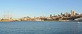
In front of the Maritime Museum is a man-made lagoon on the site of the former Black Point Cove. To the west is the horseshoe-shaped Municipal Pier. [5] The lagoon is fronted by a sandy beach and a stepped concrete seawall. To the south is a grassy area known as Victorian Park, which contains the Hyde Street cable car turnaround. Hyde Street Pier, though part of the San Francisco Maritime National Historical Park, is not part of Aquatic Park Historic District.

The Historic District was declared a National Historic Landmark in 1987, [2] [4] [6] and added to the National Register of Historic Places on January 26, 1984. [1]

The park is at the foot of Polk Street and a minute's walk from the visitor center and Hyde Street Pier. Its beach is one of the cleanest in the state. [7]

In the park near the corner of Beach and Larkin streets is California Historical Landmark marker No. 236, honoring the Spanish packet ship San Carlos , which on August 5, 1775, was the first known European ship to enter San Francisco Bay. [3] [8]

Black Point Cove was named for Black Point, which juts into the bay between North Beach and the Marina District. [9] Originally named Punta Medanos by the Spanish settlers, it was renamed Black Point after 1849. [10] The shoreline of Black Point is the last remaining section of original coastline in San Francisco east of the Golden Gate Bridge.

See also

Related Research Articles

<span class="mw-page-title-main">Russian Hill, San Francisco</span> Neighborhood in San Francisco

Russian Hill is a neighborhood of San Francisco, California. It is named after one of San Francisco's 44 hills, and one of its original "Seven Hills".

<i>Balclutha</i> (1886) Steel-hulled full rigged ship that was built in 1886

Balclutha, also known as Star of Alaska, Pacific Queen, or Sailing Ship Balclutha, is a steel-hulled full-rigged ship that was built in 1886. She is representative of several different commercial ventures, including lumber, salmon, and grain. She is a U.S. National Historic Landmark and is currently preserved at the San Francisco Maritime National Historical Park in San Francisco, California. She was added to the National Register of Historic Places on 7 November 1976.

<span class="mw-page-title-main">San Francisco Maritime National Historical Park</span> Place in California listed on National Register of Historic Places

The San Francisco Maritime National Historical Park is located in San Francisco, California, United States. The park includes a fleet of historic vessels, a visitor center, a maritime museum, and a library/research facility. Formerly referred to as the San Francisco Maritime Museum, the collections were acquired by the National Park Service in 1978. The San Francisco Maritime National Historical Park was authorized in 1988; the maritime museum is among the park's many cultural resources. The park also incorporates the Aquatic Park Historic District, bounded by Van Ness Avenue, Polk Street, and Hyde Street.

<i>C.A. Thayer</i> (1895) Schooner

C.A. Thayer is a schooner built in 1895 near Eureka, California. The schooner has been preserved and open to the public at the San Francisco Maritime National Historical Park since 1963. She is one of the last survivors of the sailing schooners in the West coast lumber trade to San Francisco from Washington, Oregon, and Northern California. She was designated a National Historic Landmark on 13 November 1966.

<i>Eureka</i> (ferryboat)

Eureka is a side-wheel paddle steamboat, built in 1890, which is now preserved at the San Francisco Maritime National Historical Park in San Francisco, California. Originally named Ukiah to commemorate the railway's recent extension into the City of Ukiah, the boat was built by the San Francisco and North Pacific Railroad Company at their Tiburon yard. Eureka has been designated a National Historic Landmark and was listed in the National Register of Historic Places on April 24, 1973.

<i>Alma</i> (1891)

Alma is an 1891-built scow schooner, which is now preserved as a National Historic Landmark at the San Francisco Maritime National Historical Park in San Francisco, California.

<i>Hercules</i> (1907) 1907-built American steam tugboat

Hercules is a 1907-built steam tugboat that is now preserved at the San Francisco Maritime National Historical Park in San Francisco, California.

<span class="mw-page-title-main">Embarcadero (San Francisco)</span> Waterfront and roadway along San Francisco Bay

The Embarcadero is the eastern waterfront and roadway of the Port of San Francisco, San Francisco, California, along San Francisco Bay. It was constructed on reclaimed land along a three mile long engineered seawall, from which piers extend into the bay. It derives its name from the Spanish verb embarcar, meaning "to embark"; embarcadero itself means "the place to embark." The Central Embarcadero Piers Historic District was added to the National Register of Historic Places on November 20, 2002.

<span class="mw-page-title-main">Fisherman's Wharf, San Francisco</span> Neighborhood of San Francisco in City and County of San Francisco, California, United States

Fisherman's Wharf is a neighborhood and popular tourist attraction in San Francisco, California. It roughly encompasses the northern waterfront area of San Francisco from Ghirardelli Square or Van Ness Avenue east to Pier 35 or Kearny Street. The F Market streetcar runs through the area, the Powell-Hyde cable car line runs to Aquatic Park, at the edge of Fisherman's Wharf, and the Powell-Mason cable car line runs a few blocks away.

<span class="mw-page-title-main">San Francisco Belt Railroad</span>

The San Francisco Belt Railroad was a short-line railroad along the Embarcadero in San Francisco, California. It began as the State Belt Railroad in 1889, and was renamed when the city bought the Port of San Francisco in 1969. As a state owned enterprise, the railroad asserted several unsuccessful claims to immunity from federal regulation. The railroad ceased operation in 1993.

<span class="mw-page-title-main">Port of San Francisco</span> Organization that oversees port facilities in San Francisco, California, United States

The Port of San Francisco is a semi-independent organization that oversees the port facilities at San Francisco, California, United States. It is run by a five-member commission, appointed by the Mayor and approved by the Board of Supervisors. The Port is responsible for managing the larger waterfront area that extends from the anchorage of the Golden Gate Bridge, along the Marina district, all the way around the north and east shores of the city of San Francisco including Fisherman's Wharf and the Embarcadero, and southward to the city line just beyond Candlestick Point. In 1968 the State of California, via the California State Lands Commission for the State-operated San Francisco Port Authority, transferred its responsibilities for the Harbor of San Francisco waterfront to the City and County of San Francisco / San Francisco Harbor Commission through the Burton Act AB2649. All eligible State port authority employees had the option to become employees of the City and County of San Francisco to maintain consistent operation of the Port of San Francisco.

<span class="mw-page-title-main">Hyde Street Pier</span>

The Hyde Street Pier, at 2905 Hyde Street, is a historic ferry pier located on the northern waterfront of San Francisco, California.

<span class="mw-page-title-main">Berkeley Marina</span> Neighborhood of Berkeley in Alameda, California, United States

The Berkeley Marina is the westernmost portion of the city of Berkeley, California, located west of the Eastshore Freeway at the foot of University Avenue on San Francisco Bay. Narrowly speaking, "Berkeley Marina" refers only to the city marina, but in common usage, it applies more generally to the surrounding area.

<span class="mw-page-title-main">James P. Delgado</span> American maritime archaeologist, explorer and author

James Preston Delgado is a maritime archaeologist, historian, maritime preservation expert, author, television host, and explorer.

<span class="mw-page-title-main">Middle Harbor Shoreline Park</span>

Middle Harbor Shoreline Park (MHSP) is located on San Francisco Bay and the Port of Oakland entrance channel, west of downtown Oakland, California. It is owned and operated by the Port of Oakland. The park entrance is at the intersection of 7th Street and Middle Harbor Road. It is open seven days a week from 8 a.m. to dusk.

<span class="mw-page-title-main">Central Embarcadero Piers Historic District</span> Historic district in California, United States

The Central Embarcadero Piers Historic District is a Registered Historic District in the city of San Francisco, California, United States. It consists of Piers 1, 1½, 3 and 5, which form one of the largest surviving pier complexes along San Francisco's Embarcadero waterfront road. It was added to the National Register of Historic Places in 2002.

<span class="mw-page-title-main">Cabrillo Beach</span>

Cabrillo Beach is a historic public beach located in San Pedro, Los Angeles, California. It is named after Juan Rodríguez Cabrillo, a Portuguese explorer who was the first to sail up the California coast. Cabrillo has two separate beach areas.

<span class="mw-page-title-main">Dolphin Club (San Francisco)</span>

The Dolphin Club, also known as the Dolphin Swimming and Boating Club, is an athletic club in San Francisco, California. It caters to open water swimming, rowing, kayaking, stand up paddleboarding, and 4-wall handball.

<span class="mw-page-title-main">Potrero Point</span> District in southeast San Francisco, California

Potrero Point is an area in San Francisco, California, east of San Francisco's Potrero Hill neighborhood. Potrero Point was an early San Francisco industrial area. The Point started as small natural land feature that extends into Mission Bay of San Francisco Bay. The Point was enlarged by blasted and cuts on the nearby cliffs. The cut material was removed and used to fill two square miles into the San Francisco bay, making hundreds of acres of flat land. The first factories opened at Potrero Point in the 1860s. Early factories were powder magazine plant, the Pacific Rolling Mill Company and small shipyards. The large Union Iron Works and its shipyards were built at the site, stated in 1849 by Peter Donahue. To power the factories and neighborhood coal and gas-powered electricity works were built, later the site became Pacific Gas and Electric Company (PG&E).

References

  1. 1 2 "National Register Information System". National Register of Historic Places . National Park Service. January 23, 2007.
  2. 1 2 "Aquatic Park Historic District". National Historic Landmark summary listing. National Park Service. Archived from the original on October 12, 2007. Retrieved October 23, 2007.
  3. 1 2 "Entrance of the San Carlos into San Francisco Bay". Office of Historic Preservation, California State Parks. Retrieved October 14, 2012.
  4. 1 2 ""Architecture in the Parks: A National Historic Landmark Theme Study: Aquatic Park Historic District", by Laura Soullière Harrison". National Historic Landmark Theme Study. National Park Service. Archived from the original on February 26, 2008. Retrieved February 26, 2008.
  5. McLean, Tessa (November 23, 2022). "Popular SF tourist destination closed indefinitely". SFGATE. Retrieved June 12, 2023.
  6. James P. Delgado (February 1, 1984). "National Register of Historic Places Inventory-Nomination: Aquatic Park Historic District" (pdf). National Park Service.{{cite journal}}: Cite journal requires |journal= (help) and Accompanying 19 photos, exterior and interior, undated.  (1.28  MiB)
  7. Carolyn Jones (May 27, 2010). "Bay Area beaches grade well for safe swimming". San Francisco Chronicle. Archived from the original on June 22, 2010. Retrieved July 14, 2010.
  8. "STORY OF THE SHIP SAN CARLOS. THE ARGOS OF THE GOLDEN GATE". San Francisco Call. November 22, 1896. Volume 80, Number 175
  9. Bevk, Alex (April 9, 2013). "Before Fort Mason and Aquatic Park, There was Black Point". Curbed. Vox Media.
  10. "Aquatic Park San Francisco Maritime National Historical Park" (PDF). Cultural Landscapes Inventory. National Park Service. 2001. Retrieved June 9, 2017.