
Saitama Prefecture is a landlocked prefecture of Japan located in the Kantō region of Honshu. Saitama Prefecture has a population of 7,338,536 and has a geographic area of 3,797 km2. Saitama Prefecture borders Tochigi Prefecture and Gunma Prefecture to the north, Nagano Prefecture to the west, Yamanashi Prefecture to the southwest, Tokyo to the south, Chiba Prefecture to the southeast, and Ibaraki Prefecture to the northeast.
Ibaraki Prefecture is a prefecture of Japan located in the Kantō region of Honshu. Ibaraki Prefecture has a population of 2,828,086 and has a geographic area of 6,097.19 square kilometres. Ibaraki Prefecture borders Fukushima Prefecture to the north, Tochigi Prefecture to the northwest, Saitama Prefecture to the southwest, Chiba Prefecture to the south, and the Pacific Ocean to the east.

The Kantō region is a geographical region of Honshu, the largest island of Japan. In a common definition, the region includes the Greater Tokyo Area and encompasses seven prefectures: Gunma, Tochigi, Ibaraki, Saitama, Tokyo, Chiba, and Kanagawa. Slightly more than 45 percent of the land area within its boundaries is the Kantō Plain. The rest consists of the hills and mountains that form land borders with other regions of Japan.

Musashi Province was a province of Japan, which today comprises Tokyo Metropolis, most of Saitama Prefecture and part of Kanagawa Prefecture. It was sometimes called Bushū (武州). The province encompassed Kawasaki and Yokohama. Musashi bordered on Kai, Kōzuke, Sagami, Shimōsa, and Shimotsuke Provinces.
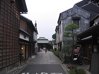
Kawagoe is a city in Saitama Prefecture, Japan. As of 1 February 2021, the city had an estimated population of 353,214 in 162,210 households and a population density of 3200 persons per km2. The total area of the city is 109.13 square kilometres (42.14 sq mi). The city is known locally as "Little Edo" after the old name for Tokyo, due to its many historic buildings.

Kawaguchi is a city located in Saitama Prefecture, Japan. As of 1 January 2021, the city had an estimated population of 607,373 in 293,582 households and a population density of 9800 persons per km². The total area of the city is 61.95 square kilometres (23.92 sq mi). It is the Greater Tokyo Area's 8th most populated city, and second largest in Saitama Prefecture, after eponymous Saitama.
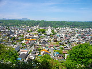
Chichibu is a city located in Saitama Prefecture, Japan. As of 1 January 2021, the city had an estimated population of 61,159 in 26,380 households and a population density of 110 inhabitants per square kilometre (280/sq mi). The total area of the city is 577.83 square kilometres (223.10 sq mi).

Ageo is a city located in Saitama Prefecture, Japan. As of February 1, 2024, the city had an estimated population of 230,041 in 107,555 households and a population density of 5100 persons per km2. The total area of the city is 45.51 square kilometres (17.57 sq mi).

Koshigaya is a city located in Saitama Prefecture, Japan. As of 1 January 2021, the city had an estimated population of 345,353 in 158,022 households and a population density of 5700 persons per km2. The total area of the city is 60.24 square kilometres (23.26 sq mi). It is famous for producing daruma dolls.

Shiki is a city located in Saitama Prefecture, Japan. As of 1 January 2021, the city had an estimated population of 76,445 in 35,407 households and a population density of 8400 persons per km2. The total area of the city is 9.05 square kilometres (3.49 sq mi).
Satte is a city located in Saitama Prefecture, Japan. As of 1 January 2021, the city had an estimated population of 50,256 in 22,853 households and a population density of 1,500 inhabitants per square kilometre (3,900/sq mi). The total area of the city is 33.93 square kilometres (13.10 sq mi).

Adachi is a special ward in the Tokyo Metropolis in Japan. It is located to the north of the heart of Tokyo. The ward consists of two separate areas: a small strip of land between the Sumida River and Arakawa River and a larger area north of the Arakawa River. The ward is bordered by the cities of Kawaguchi, Sōka and Yashio in Saitama and Katsushika, Sumida, Arakawa and Kita in Tokyo. The ward is called Adachi City in English.

The Arakawa River or Ara River is a 173-kilometre (107 mi) long river that flows through Saitama Prefecture and Tokyo. Its average flow in 2002 was 30 m3/s.

Saitama is the capital and largest city of Saitama Prefecture, Japan. Its area incorporates the former cities of Urawa, Ōmiya, Yono and Iwatsuki. It is a city designated by government ordinance. As of 1 February 2021, the city had an estimated population of 1,324,854, and a population density of 6,093 people per km². Its total area is 217.43 square kilometres (83.95 sq mi).

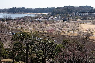
Kumagaya is a city located in Saitama Prefecture, Japan. As of 1 February 2021, the city had an estimated population of 195,277 in 87,827 households and a population density of 1200 persons per km2. The total area of the city is 159.82 square kilometres (61.71 sq mi).

The Edo River is a river in the Kantō region of Japan. It splits from the Tone River at the northernmost tip of Noda City in the Sekiyado district, crosses through Nagareyama and Matsudo, and empties into Tokyo Bay at Ichikawa, Chiba Prefecture. The Edo forms the borders between Tokyo, Chiba, and Saitama prefectures. The Edo River is 59.5 kilometres (37.0 mi) long.

The Naka River is a river that flows from Hanyu, Saitama to Edogawa, Tokyo, Japan, where it merges with the Arakawa River. It is 83.7 kilometres (52.0 mi) long.

The Watarase River is a major river in the northern Kantō region of Japan. A tributary of the Tone River, it is 106.7 kilometres (66.3 mi) in length and drains an area of 2,621 square kilometres (1,012 sq mi). Its source is at Mount Sukai on the boundary of the city of Nikkō in Tochigi Prefecture and it empties into the Tone River at the boundary of the city of Koga in Ibaraki Prefecture and the city of Kazo in Saitama Prefecture. It is classed as a First-class river by the Japanese government.

The Iwaki River is a river that crosses western Aomori Prefecture, Japan. It is 102 kilometers (63 mi) in length and has a drainage area of 2,544 square kilometers (982 sq mi). Under the Rivers Act of 1964 the Iwaki is designated as a Class 1 River and is managed by the Japanese Ministry of Land, Infrastructure, Transport and Tourism. The Iwaki River is the longest river in Aomori Prefecture, and is the source of irrigation for the large-scale rice and apple production of the prefecture. The Iwaki River, in the Tōhoku region north of the Fukushima Daiichi Nuclear Power Plant, remains unpolluted by radioactive materials after the Fukushima Daiichi nuclear disaster. Testing for caesium-134 and caesium-137 is carried out and published on a bimonthly basis.


