Beaverdam, Ohio

Last updated

Beaverdam, Ohio
Beaverdam-ohio-downtown.jpg
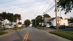
Streetside in Beaverdam
OHMap-doton-Beaverdam.png
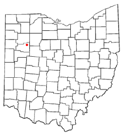
Location of Beaverdam, Ohio
Map of Allen County Ohio Highlighting Beaverdam Village.png
Location of Beaverdam in Allen County
USA Ohio location map.svg
Red pog.svg
Beaverdam
Location in Ohio
Usa edcp location map.svg
Red pog.svg
Beaverdam
Beaverdam (the United States)
North America laea location map.svg
Red pog.svg
Beaverdam
Beaverdam (North America)
Coordinates: 40°49′58″N83°58′26″W / 40.83278°N 83.97389°W / 40.83278; -83.97389
Country United States
State Ohio
County Allen
Township Richland
Government
  MayorRoberta Jean Beemer[ citation needed ]
Area
[1]
  Total0.63 sq mi (1.63 km2)
  Land0.63 sq mi (1.63 km2)
  Water0.00 sq mi (0.00 km2)
Elevation
[2]
863 ft (263 m)
Population
 (2020)
  Total319
  Density506.35/sq mi (195.54/km2)
Time zone UTC-5 (Eastern (EST))
  Summer (DST) UTC-4 (EDT)
ZIP code
45808
Area code 419
FIPS code 39-04752 [3]
GNIS feature ID2398061 [2]
Website www.beaverdamoh.com

Beaverdam is a village in Richland Township, Allen County, Ohio, United States. Its population was 319 at the 2020 census. Beaverdam is part of the Lima, Ohio Metropolitan Statistical Area.

Contents

History

Beaverdam was laid out in 1853. [4] The village was so named on account of there being beaver dams near the original town site. [5] A post office called Beaver Dam was established in 1850, the name was changed to Beaverdam in 1895, and the post office closed in 2006. [6] The village was incorporated in 1878. [7]

Geography

According to the United States Census Bureau, the village has a total area of 0.61 square miles (1.58 km2), all land. [8]

Transportation

Beaverdam lies at the junction of the old Lincoln Highway and the Dixie Highway. These early highways were begun in 1914.

Currently Beaverdam's economy is dominated by three large truck stops on what is now the junction of Interstate 75 and U.S. Route 30. Beaverdam was the eastern terminus of the four lane section of US 30. This meant that vehicular traffic going east on the four lane portion of US 30 that extended from Fort Wayne, Indiana had to exit the four-lane road and shift to a two-lane road. This required exit enhanced the village's function as an area for refueling of vehicles. US 30 is now a continuous four-lane highway in this part of Ohio that bypasses Beaverdam, but the significance of the junction as a major fuel stop has not been diminished. In the summer of 2006 the exit ramps and overpass on I-75 were widened to accommodate heavy truck and car traffic to the truck stops.

Demographics

Historical population
CensusPop.Note
1880 353
1890 39712.5%
1900 47720.2%
1910 455−4.6%
1920 394−13.4%
1930 360−8.6%
1940 3774.7%
1950 45019.4%
1960 51414.2%
1970 5252.1%
1980 492−6.3%
1990 467−5.1%
2000 356−23.8%
2010 3827.3%
2020 319−16.5%
U.S. Decennial Census [9]

The median income for a household in the village was $39,063, and the median income for a family was $47,188. Males had a median income of $29,375 versus $21,932 for females. The per capita income for the village was $14,750. About 10.3% of families and 8.9% of the population were below the poverty line, including 19.8% of those under age 18 and none of those age 65 or over.

2010 census

As of the census [10] of 2010, there were 382 people, 144 households, and 107 families residing in the village. The population density was 626.2 inhabitants per square mile (241.8/km2). There were 153 housing units at an average density of 250.8 per square mile (96.8/km2). The racial makeup of the village was 96.9% White, 0.5% African American, 0.3% Native American, 0.3% Asian, and 2.1% from two or more races. Hispanic or Latino of any race were 1.3% of the population.

There were 144 households, of which 35.4% had children under the age of 18 living with them, 52.1% were married couples living together, 15.3% had a female householder with no husband present, 6.9% had a male householder with no wife present, and 25.7% were non-families. 20.8% of all households were made up of individuals, and 4.9% had someone living alone who was 65 years of age or older. The average household size was 2.65 and the average family size was 2.98.

The median age in the village was 34.8 years. 24.9% of residents were under the age of 18; 9.4% were between the ages of 18 and 24; 25.7% were from 25 to 44; 27.5% were from 45 to 64; and 12.6% were 65 years of age or older. The gender makeup of the village was 51.6% male and 48.4% female.

Related Research Articles

<span class="mw-page-title-main">Allen County, Ohio</span> County in Ohio, United States

Allen County is a county located in the northwestern part of the U.S. state of Ohio. Its county seat and largest city is Lima. The county was created in 1820 and organized in 1831. The county is named in honor of Colonel John Allen, who was killed leading his men at the Battle of Frenchtown during the War of 1812.

<span class="mw-page-title-main">Benzonia Township, Michigan</span> Civil township in Michigan, United States

Benzonia Township is a civil township of Benzie County in the U.S. state of Michigan. As of the 2020 census, the township population was 1,870.

<span class="mw-page-title-main">Fife Lake Township, Michigan</span> Civil township in Michigan, United States

Fife Lake Township is a civil township of Grand Traverse County in the U.S. state of Michigan. As of the 2020 census, the township population was 1,526, a slight increase from 1,517 at the 2000 census. The village of Fife Lake is located within the township.

<span class="mw-page-title-main">Mayfield Township, Grand Traverse County, Michigan</span> Civil township in Michigan, United States

Mayfield Township is a civil township of Grand Traverse County in the U.S. state of Michigan. The population was 1,786 at the 2020 census, an increase from 1,550 at the 2010 census.

<span class="mw-page-title-main">Hartland Township, Michigan</span> Civil township in Michigan, United States

Hartland Township is a civil township of Livingston County in the U.S. state of Michigan. The population was 14,663 at the 2010 census, up from 10,996 at the 2000 census.

<span class="mw-page-title-main">Erie Township, Michigan</span> Civil township in Michigan, United States

Erie Township is a civil township of Monroe County in the U.S. state of Michigan. The population was 4,299 at the 2020 census. Sharing a southern border with the city of Toledo, Ohio, about 45 miles (72 km) southwest of the city of Detroit, the township is one of the southernmost areas included in the Detroit–Warren–Ann Arbor Combined Statistical Area.

<span class="mw-page-title-main">Seaman, Ohio</span> Village in Ohio, United States

Seaman is a village in Scott Township, Adams County, Ohio, United States. The population was 973 at the 2020 census.

<span class="mw-page-title-main">Cairo, Ohio</span> Village in Ohio, United States

Cairo is a village in Allen County, Ohio, United States. As of the 2020 census it had a population of 517. It is included in the Lima Metropolitan Statistical Area.

<span class="mw-page-title-main">Harrod, Ohio</span> Village in Ohio, United States

Harrod is a village in Allen County, Ohio, United States. The population was 423 at the 2020 census. It is included in the Lima, Ohio Metropolitan Statistical Area.

<span class="mw-page-title-main">Spencerville, Ohio</span> Village in Ohio, United States

Spencerville is a village in Allen County, Ohio, United States. The population was 2,198 at the 2020 census. It is included in the Lima, Ohio Metropolitan Statistical Area.

<span class="mw-page-title-main">Olde West Chester, Ohio</span> Census-designated place in Ohio, United States

Olde West Chester is a census-designated place (CDP) in West Chester Township, Butler County, Ohio, United States. The population was 201 at the 2020 census.

<span class="mw-page-title-main">Delta, Ohio</span> Village in Ohio, United States

Delta is a village in Fulton County, Ohio, United States. The population was 3,316 at the 2020 census.

<span class="mw-page-title-main">Clay Center, Ohio</span> Village in Ohio, United States

Clay Center is a village in Ottawa County, Ohio, United States. The population was 262 at the 2020 census.

<span class="mw-page-title-main">Buffalo Township, Butler County, Pennsylvania</span> Township in Pennsylvania, United States

Buffalo Township is a township in Butler County, Pennsylvania, United States. The population was 7,896 at the 2020 census.

<span class="mw-page-title-main">Summerhill Township, Cambria County, Pennsylvania</span> Township in Pennsylvania, United States

Summerhill Township is a township in Cambria County, Pennsylvania, United States. The population was 2,467 at the 2010 census. It is part of the Johnstown, Pennsylvania Metropolitan Statistical Area.

<span class="mw-page-title-main">Upper Allen Township, Pennsylvania</span> Township in Pennsylvania, United States

Upper Allen Township is a township in Cumberland County, Pennsylvania, United States. The population was 23,183 at the 2020 census, up from 18,059 at the 2010 census.

<span class="mw-page-title-main">East Hanover Township, Dauphin County, Pennsylvania</span> Township in Pennsylvania, United States

East Hanover Township is a township in Dauphin County, Pennsylvania, United States. The population was 6,009 at the 2020 census.

<span class="mw-page-title-main">Lawrence Township, Tioga County, Pennsylvania</span> Township in Pennsylvania, United States

Lawrence Township is a township in Tioga County, Pennsylvania, United States. The population was 1,613 at the 2020 census.

<span class="mw-page-title-main">College Corner, Ohio</span> Village in Ohio, United States

College Corner is a village in Butler and Preble counties in the southwestern part of the U.S. state of Ohio, 5 miles (8 km) northwest of Oxford. The population was 387 at the 2020 census. The village lies on the state line with Indiana, where it borders the town of West College Corner. The public school, part of the Union County–College Corner Joint School District, is bisected by the state line and is operated jointly with Indiana authorities.

<span class="mw-page-title-main">Winchester, Adams County, Ohio</span> Village in Ohio, United States

Winchester is a village in Adams County, Ohio, United States. The population was 987 at the 2020 census. The name of the surrounding township is also named Winchester.

References

  1. "ArcGIS REST Services Directory". United States Census Bureau. Retrieved September 20, 2022.
  2. 1 2 U.S. Geological Survey Geographic Names Information System: Beaverdam, Ohio
  3. "U.S. Census website". United States Census Bureau . Retrieved January 31, 2008.
  4. History of Allen County, Ohio: Containing a History of the County, Its Townships, Towns, Villages, Schools, Churches, Industries, Etc. Warner, Beers & Company. 1885. p. 535.
  5. Rusler, William (1921). A Standard History of Allen County, Ohio: An Authentic Narrative of the Past, with Particular Attention to the Modern Era in the Commercial, Industrial, Educational, Civic and Social Development. American Historical Society. p.  207.
  6. "Allen County". Jim Forte Postal History. Retrieved January 10, 2016.
  7. History of Allen County, Ohio: Containing a History of the County, Its Townships, Towns, Villages, Schools, Churches, Industries, Etc. Warner, Beers & Company. 1885. p. 536.
  8. "US Gazetteer files 2010". United States Census Bureau. Archived from the original on January 25, 2012. Retrieved January 6, 2013.
  9. "Census of Population and Housing". Census.gov. Retrieved June 4, 2015.
  10. "U.S. Census website". United States Census Bureau . Retrieved January 6, 2013.