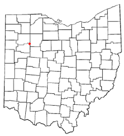
Bluffton, Ohio | |
---|---|
Motto: "150 Years Of Progress" | |
Coordinates: 40°53′22″N83°52′45″W / 40.88944°N 83.87917°W | |
Country | United States |
State | Ohio |
Counties | Allen, Hancock |
Townships | Richland, Orange |
Government | |
• Mayor | Richard Johnson[ citation needed ] |
Area | |
• Total | 3.77 sq mi (9.78 km2) |
• Land | 3.69 sq mi (9.57 km2) |
• Water | 0.08 sq mi (0.21 km2) |
Elevation | 820 ft (250 m) |
Population (2020) | |
• Total | 3,967 |
3,903 | |
• Density | 1,073.61/sq mi (414.57/km2) |
Time zone | UTC−5 (EST) |
• Summer (DST) | UTC−4 (EDT) |
ZIP code | 45817 |
Area code | 419, 567 |
FIPS code | 39-07426 [4] |
GNIS feature ID | 2398144 [2] |
Website | www |
Bluffton, originally known as Shannon, is a village in Allen and Hancock counties in the U.S. state of Ohio. The population was 3,967 at the 2020 census. Bluffton is home to Bluffton University, a four-year educational institution affiliated with Mennonite Church USA. Bluffton is served by the Bluffton general aviation airport. Bluffton participates in the Tree City USA program.
The Allen County portion of Bluffton is part of the Lima Metropolitan Statistical Area, while the Hancock County portion is part of the Findlay Micropolitan Statistical Area.
The village was founded in 1831 by Swiss Mennonites, German Reformists and Irish Catholics. It was originally named 'Crogan's Corners' after the postmaster. When the citizens chose to incorporate as a village, the Irish suggested the name 'Shannon' because of the green fields around the area. As there was already a village named Shannon in the state, the town was renamed Bluffton for the hilly terrain of the town site. [5]
Bank robber John Dillinger robbed the Bluffton Bank (now known as Citizens National Bank of Bluffton) of $6,000 on August 14, 1933. [6]
In 2011, Bluffton celebrated its 150th birthday with a series of town-wide events. [7]
According to the United States Census Bureau, the village has a total area of 3.62 square miles (9.38 km2), of which 3.55 square miles (9.19 km2) is land and 0.07 square miles (0.18 km2) is water. [8]
Riley Creek flows through Bluffton.
Census | Pop. | Note | %± |
---|---|---|---|
1870 | 489 | — | |
1880 | 1,290 | 163.8% | |
1890 | 1,290 | 0.0% | |
1900 | 1,783 | 38.2% | |
1910 | 1,953 | 9.5% | |
1920 | 1,950 | −0.2% | |
1930 | 2,035 | 4.4% | |
1940 | 2,077 | 2.1% | |
1950 | 2,423 | 16.7% | |
1960 | 2,591 | 6.9% | |
1970 | 2,935 | 13.3% | |
1980 | 3,310 | 12.8% | |
1990 | 3,367 | 1.7% | |
2000 | 3,896 | 15.7% | |
2010 | 4,125 | 5.9% | |
2020 | 3,967 | −3.8% | |
2023 (est.) | 3,903 | [3] | −1.6% |
U.S. Decennial Census [9] |
As of the census [10] of 2010, there were 4,125 people, 1,428 households, and 913 families living in the village. The population density was 1,162.0 inhabitants per square mile (448.7/km2). There were 1,522 housing units at an average density of 428.7 per square mile (165.5/km2). The racial makeup of the village was 95.3% White, 1.6% African American, 0.2% Native American, 0.9% Asian, 0.8% from other races, and 1.2% from two or more races. Hispanic or Latino of any race were 1.5% of the population.
There were 1,428 households, of which 29.5% had children under the age of 18 living with them, 53.4% were married couples living together, 8.1% had a female householder with no husband present, 2.5% had a male householder with no wife present, and 36.1% were non-families. 33.2% of all households were made up of individuals, and 18.3% had someone living alone who was 65 years of age or older. The average household size was 2.31 and the average family size was 2.95.
The median age in the village was 34 years. 19.9% of residents were under the age of 18; 21.8% were between the ages of 18 and 24; 19.2% were from 25 to 44; 20% were from 45 to 64; and 19% were 65 years of age or older. The gender makeup of the village was 45.6% male and 54.4% female.
As of the census [4] of 2000, there were 3,896 people, 1,329 households, and 851 families living in the village. The population density was 1,170.2 inhabitants per square mile (451.8/km2). There were 1,427 housing units at an average density of 428.6 per square mile (165.5/km2). The racial makeup of the village was 97.82% White, 0.77% African American, 0.05% Native American, 0.54% Asian, 0.18% from other races, and 0.64% from two or more races. Hispanic or Latino of any race were 1.18% of the population.
There were 1,329 households, out of which 28.3% had children under the age of 18 living with them, 54.3% were married couples living together, 7.3% had a female householder with no husband present, and 35.9% were non-families. 33.1% of all households were made up of individuals, and 18.9% had someone living alone who was 65 years of age or older. The average household size was 2.32 and the average family size was 2.99.
In the village, the population was spread out, with 19.7% under the age of 18, 22.3% from 18 to 24, 21.3% from 25 to 44, 16.8% from 45 to 64, and 20.0% who were 65 years of age or older. The median age was 33 years. For every 100 females there were 76.4 males. For every 100 females age 18 and over, there were 73.4 males.
The median income for a household in the village was $43,208, and the median income for a family was $54,948. Males had a median income of $40,208 versus $21,563 for females. The per capita income for the village was $18,711. About 4.9% of families and 5.7% of the population were below the poverty line, including 3.6% of those under age 18 and 10.6% of those age 65 or over.
Bluffton is located approximately halfway between Lima and Findlay in northwest Ohio along Interstate 75.
Modern manufacturing in Bluffton includes the international firm Sumitomo Riko, a cooperative venture between Duramax and Tokai Rubber of Japan, that makes rubber components for the auto industry. GROB Systems, a division of the German company GROB Group, produces machining and automation systems at its plant in Bluffton.
The downtown area is anchored by the 19th century town hall and includes a local farmers market on Saturday mornings from May through October. With an average of 20 vendors, shoppers can choose from local foods and produce, as well as potted herbs, annuals, perennials, shrubs, and trees. [11]
Ten Thousand Villages is a fair-trade retailer that was founded in Bluffton. The shop sells products made by artisans in developing countries.
Bluffton High School sports participate in the Northwest Conference, an athletic body sanctioned by the Ohio High School Athletic Association (OHSAA) which includes the Ada Bulldogs, Allen East Mustangs, Bluffton Pirates, Columbus Grove Bulldogs, Convoy Crestview Knights, Delphos Jefferson Wildcats, Lincolnview Lancers, Paulding Panthers, and Spencerville Bearcats.
Bluffton is home to Bluffton University, a four-year educational institution affiliated with the Mennonite Church USA. [12]
WBWH-LP (96.1 FM) serves the Bluffton community as its only full-time radio station.
Lafayette is a village in Allen County, Ohio, United States. The population was 406 at the 2020 census. It is included in the Lima, Ohio Metropolitan Statistical Area.
Savannah is a village in Ashland County, Ohio, United States. The population was 329 at the 2020 census.
Yorkshire is a village in Darke County, Ohio, United States. The population was 95 at the 2020 census.
Bay View is a village in Erie County, Ohio, United States. The population was 608 at the 2020 census. It is part of the Sandusky, Ohio Metropolitan Statistical Area.
Fruit Hill is a census-designated place (CDP) in Anderson Township, Hamilton County, Ohio, United States. The population was 3,748 at the 2020 census.
Leesburg is a village in Highland County, Ohio, United States. The population was 1,273 at the 2020 census.
Chesapeake is a village in Lawrence County, Ohio, United States. The population was 765 as of the 2020 census. It lies across the Ohio River from Huntington, West Virginia, at the mouth of Symmes Creek.
Hanging Rock is a village in Lawrence County, Ohio, United States, along the Ohio River. The population was 204 at the 2020 census.
Hanover is a village in Licking County, Ohio, United States. The population was 1,270 at the 2020 census. The village lies along Ohio State Route 16.
Rochester is a village in Lorain County, Ohio, United States, along the West Branch of the Black River. The population was 159 at the 2020 census.
South Amherst is a village in Lorain County, Ohio, United States. The population was 1,581 at the 2020 census.
Berkey is a village in Lucas County, Ohio, United States. The population was 275 at the 2020 census.
Racine is a village in Meigs County, Ohio, United States, along the Ohio River. The population was 683 at the 2020 census.
Miltonsburg is a village in Monroe County, Ohio, United States. The population was 42 at the 2020 census. Miltonsburg was named after Milton Pierson, son of Ohio pioneer David Pierson. David Pierson named Clarington, Ohio after his daughter Clarinda.
Adamsville is a village in Muskingum County, Ohio, United States. The population was 140 at the 2020 census. It is part of the Zanesville micropolitan area.
Pandora is a village in Putnam County, Ohio, United States, located on the Riley Creek. The population was 1,204 at the 2020 census.
Helena is a village in Sandusky County, Ohio, United States. The population was 211 at the 2020 census.
Hamden is a village in Vinton County, Ohio, United States. The population was 727 at the 2020 census.
Butlerville is a village in central Harlan Township, Warren County, Ohio, United States, located in the southwestern part of the state. The population was 155 at the 2020 census.
Macksburg is a village in Washington County, Ohio, United States, along the West Fork of Duck Creek. The population was 120 at the 2020 census. The village is about 28 miles (45 km) south of Cambridge, Ohio.