
Hancock County is a county located in the U.S. state of Ohio. As of the 2020 census, the population was 74,920. Its county seat and largest city is Findlay. The county was created in 1820 and later organized in 1828. It was named for John Hancock, the first signer of the Declaration of Independence.

Hancock is a city in Pottawattamie County, Iowa, United States, along the West Nishnabotna River. The population was 200 at the time of the 2020 census.
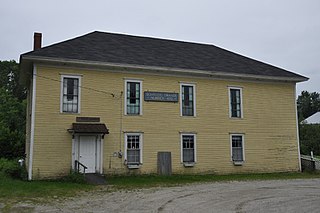
Franklin is a town in Hancock County, Maine, United States. The population was 1,567 at the 2020 census. The town's namesake is Benjamin Franklin.

Verona Island is a town located on an island of the same name in the Penobscot River in Hancock County, Maine, United States. The population was 507 at the 2020 census.
Waltham is a town in Hancock County, Maine, United States. The population was 332 at the 2020 census.

Arcadia is a village in Hancock County, Ohio, United States. The population was 564 at the 2020 census.
Arlington is a village in Hancock County, Ohio, United States. The population was 1,492 at the 2020 census.

Benton Ridge is a village in Hancock County, Ohio, United States. The population was 272 at the 2020 census. It is within the boundaries of the Liberty-Benton Local School district.

Jenera is a village in Hancock County, Ohio, United States. The population was 257 at the 2020 census. It is surrounded by Van Buren Township and is part of the Cory-Rawson Local School District.

Mount Cory is a village in Hancock County, Ohio, United States. The population was 225 at the 2020 census.

Rawson is a village in Hancock County, Ohio, United States. The population was 567 at the 2020 census.

Vanlue is a village in Hancock County, Ohio, United States. The population was 341 at the 2020 census.

Belmore is a village in Putnam County, Ohio, United States. The population was 65 at the 2020 census.

Cloverdale is a village in Perry Township, Putnam County, Ohio, United States. The population was 170 at the 2020 census.

Continental is a village in Putnam County, Ohio, United States. The population was 1,102 at the 2020 census.

Miller City is a village in Putnam County, Ohio, United States. The population was 134 at the 2020 census.

Ottoville is a village in Putnam County, Ohio, in the United States. The population was 966 at the 2020 census.

West Leipsic is a village in Putnam County, Ohio, United States. The population was 226 at the 2020 census.

Hancock is a village in Waushara County, Wisconsin, United States. The population was 417 at the 2010 census. The village is located within the Town of Hancock.
Hancock founded in 1850 is a town in Waushara County, Wisconsin, United States. The population was 531 at the 2000 census. The Village of Hancock is located within the town.


