
Hobart is the capital and most populous city of the Australian island state of Tasmania. Home to almost half of all Tasmanians, it is the southernmost and least-populated Australian state capital city, and second-smallest if territories are taken into account, before Darwin, Northern Territory. Hobart is located in Tasmania's south-east on the estuary of the River Derwent, making it the most southern of Australia's capital cities. Its skyline is dominated by the 1,271-metre (4,170 ft) kunanyi/Mount Wellington, and its harbour forms the second-deepest natural port in the world, with much of the city's waterfront consisting of reclaimed land. The metropolitan area is often referred to as Greater Hobart, to differentiate it from the City of Hobart, one of the seven local government areas that cover the city. It has a mild maritime climate.
Councils of Tasmania are the 29 administrative districts of the Australian state of Tasmania. Local government areas (LGAs), more generally known as councils, are the tier of government responsible for the management of local duties such as road maintenance, town planning and waste management.

The River Derwent is a river located in Tasmania, Australia. It is also known by the palawa kani name timtumili minanya. The river rises in the state's Central Highlands at Lake St Clair, and descends more than 700 metres (2,300 ft) over a distance of more than 200 kilometres (120 mi), flowing through Hobart, the state's capital city, before emptying into Storm Bay and flowing into the Tasman Sea. The banks of the Derwent were once covered by forests and occupied by Aboriginal Tasmanians. European settlers farmed the area and during the 20th century many dams were built on its tributaries for the generation of hydro-electricity.

Clarence City Council is a local government body in Tasmania, and one of the five municipalities that constitutes the Greater Hobart Area. The Clarence local government area has a population of 61,531, covering the eastern shore of the Derwent River from Otago to the South Arm Peninsula and the smaller localities of Cambridge, Richmond, and Seven Mile Beach.

Bellerive Oval, known commercially as Blundstone Arena for sponsorship reasons, is a cricket and Australian rules football ground located in Bellerive, a suburb on the eastern shore of Hobart, Australia, holding 20,000 people it is the largest capacity stadium in Tasmania. It is the only venue in Tasmania which hosts international cricket matches.

Bellerive is a suburb of the City of Clarence, part of the greater Hobart area, Tasmania, Australia. It stretches from Kangaroo Bay where it borders Rosny Park, around the curved shoreline of Bellerive Esplanade to Kangaroo Bluff, then down to Bellerive Beach and east to Second Bluff, where Bellerive borders Howrah. To the north Bellerive is bordered by the small foothills of Waverly Flora Park.
Howrah is a residential locality in the local government area (LGA) of Clarence in the Hobart LGA region of Tasmania. The locality is about 5 kilometres (3.1 mi) south-east of the town of Rosny Park. The 2021 Census recorded a population of 9,545 for the state suburb of Howrah. It is a suburb of the City of Clarence. It is east of Bellerive and north of Tranmere.
Montagu Bay is a suburb of Hobart, Tasmania, located in the City of Clarence on the eastern shore of the Derwent River, about four kilometres from the city centre of greater Hobart. It is a small primarily residential suburb located between Rosny, Rose Bay and Lindisfarne and is centred on a small bay of the same name, formerly known as Smelting Works Bay. The bay has a boat ramp and jetty, and is frequently filled with yachts and other vessels at anchor.

Taroona is a major residential suburb approximately 15 minutes drive from the centre of Hobart, Tasmania on the scenic route between Hobart and Kingston. Although on the edges of the City of Hobart, Taroona is actually part of the municipality of Kingborough. Taroona is bounded on the east by the Derwent River, and has several beaches along the shore, the main beaches with public access are Taroona Beach, Hinsby Beach and Dixons Beach. Past Hinsby Beach, the Alum Cliffs form a section of cliffed coast to the neighbouring suburb of Bonnet Hill.
Clarence High School is a government co-educational comprehensive junior secondary school located in Bellerive, a suburb of Hobart, Tasmania, Australia. Established in 1959, the school caters for approximately 600 students from Years 7 to 10. The school is administered by the Tasmanian Department of Education.
Rosny Park is a suburb of Hobart, Tasmania, located in the City of Clarence on the eastern shore of the Derwent River. It is about five kilometres from the city centre of Hobart. Rosny Park is the commercial twin of its residential namesake, Rosny.

Rose Bay is a suburb of the City of Clarence in greater Hobart, capital city of Tasmania, Australia. Rose Bay is a small suburb, making up only approximately 0.9 square kilometres with nearly one fourth of that area (23.2%) being parkland. At the 2016 Census the suburb recorded a population of 1,102 people.
Howrah Beach is a popular beach destination along the River Derwent in Howrah, a suburb of Hobart, Tasmania, Australia. The south-facing beach neighbours Bellerive Beach to the west and is bookended by Howrah Point to the east. The beach has views of the Derwent estuary, the neighbouring suburb of Tranmere, Sandy Bay on the western shore, and southern views of South Arm, Tinderbox and the northern tip of Bruny Island. Howrah Beach is backed by a narrow tree-lined reserve and private properties, the Clarence Foreshore Trail, Clarence High School adjoining Wentworth Park, Howrah Community Centre, Howrah Men's Shed and the Sunshine Tennis Club.
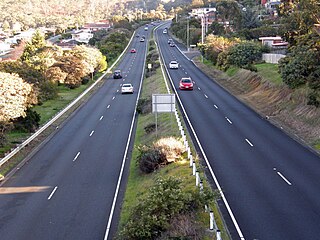
The South Arm Highway is a highway serving the southern suburbs of Hobart, on the eastern shore of the River Derwent in Tasmania, Australia. The highway is a major trunk road that carries heavy commuter traffic south from the Eastern Outlet to Howrah and Rokeby. As one of the Tasman Highway's principle Feeders and one of the eastern shore's major transport corridors, The South Arm Highway facilitates the movement of traffic between the suburbs and satellite communities to the south with the city centre and ultimately, other major cross city highways. With annual average daily traffic (AADT) of 17,000, the highway is considered a major traffic corridor within Hobart. The designation "South Arm Highway" arises from its journey south to South Arm.
The 1999 TSFL premiership season was an Australian rules football competition, staged across Tasmania, Australia over eighteen roster rounds and four finals series matches between 10 April and 18 September 1999. This was the fourteenth season of statewide football and the League was known as the Chickenfeed Super League under a commercial naming-rights sponsorship agreement with Chickenfeed Bargain Stores in Hobart worth A$350,000.

Nutgrove Beach is a popular beach destination along the River Derwent in Sandy Bay, Hobart, Tasmania. The north facing beach has views of kunanyi / Mount Wellington, Lords Beach, Wrest Point Hotel Casino, the Tasman Bridge, and the City of Clarence on the eastern shore. Nutgrove Beach neighbours Long Beach and Red Chapel Beach, and is within close proximity to the Sandy Bay Sailing Club and Lower Sandy Bay shops. The beach is dog-friendly and has bathroom facilities.

Long Beach is a popular beach destination along the River Derwent in Sandy Bay, Hobart, Tasmania. The east facing beach has views of the City of Clarence on the eastern shore and Blinking Billy Point. Long Beach neighbours Nutgrove Beach and is within close proximity to the Long Beach Reserve Playground, Sandy Bay Sailing Club, Sandy Bay Regatta Association, Hobart Pétanque Club and Lower Sandy Bay shops. Long Beach has a sea pontoon for swimmers and bathroom facilities.

Lords Beach is a suburban beach along the River Derwent in Sandy Bay, Hobart, Tasmania. The north-east facing beach has views of Wrest Point Hotel Casino, Nutgrove Beach and the City of Clarence on the eastern shore. Containing several raised jetties and covered piers, Lords Beach neighbours Red Chapel Beach to the west and Dunkley’s Point on the east.
Taroona Beach is a popular beach destination along the River Derwent in Taroona, Hobart, Tasmania. The south facing beach looks directly out to Storm Bay and the Tasman Sea, with views of the Derwent estuary, the City of Clarence on the eastern shore, Opossum Bay, South Arm, the Alum Cliffs and northern tip of Bruny Island. Taroona Beach is situated between Hinsby Beach and Crayfish Point, home of the Fisheries and Aquaculture Centre for the Institute for Marine and Antarctic Studies. Taroona Beach contains a boat ramp and is backed by Taroona Park which contains bathroom facilities, a skate park, scout hall, the Taroona Tennis Club, and the Taroona Bowls and Community Club.
Hinsby Beach is a beach along the River Derwent in the Hobart suburb of Taroona, Australia. The south facing beach looks directly out to Storm Bay and the Tasman Sea, with views of the Derwent estuary, the Alum Cliffs, Taroona Shot Tower, the City of Clarence on the eastern shore and Opossum Bay, South Arm. Hinsby Beach is situated between the Alum Cliffs and Taroona Beach. A naturally secluded section of the beach, beyond the rocky south-western outcrop is a zoned naturist beach.


