Benton Ridge, Ohio

Last updated

Benton Ridge, Ohio
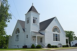
Benton Ridge Good Shepherd UMC.jpg
Good Shepherd United Methodist Church
OHMap-doton-Benton Ridge.png
Location of Benton Ridge, Ohio
Map of Hancock County Ohio Highlighting Benton Ridge.png
Location of Benton Ridge in Hancock County
Coordinates: 41°00′16″N83°47′31″W / 41.00444°N 83.79194°W / 41.00444; -83.79194
Country United States
State Ohio
County Hancock
Government
  Type Village council
Area
[1]
  Total
0.38 sq mi (0.97 km2)
  Land0.38 sq mi (0.97 km2)
  Water0.00 sq mi (0.00 km2)
Elevation
[2]
784 ft (239 m)
Population
 (2020)
  Total
272
  Estimate 
(2023) [3]
263
  Density725.33/sq mi (280.26/km2)
Time zone UTC-5 (Eastern (EST))
  Summer (DST) UTC-4 (EDT)
ZIP code
45816
Area code 419
FIPS code 39-05662 [4]
GNIS feature ID2398098 [2]

Benton Ridge is a village in Hancock County, Ohio, United States. The population was 272 at the 2020 census. It is within the boundaries of the Liberty-Benton Local School district.

Contents

History

Benton Ridge was originally called Benton, and under the latter name was laid out in 1835 and named for Thomas Hart Benton (1782–1858), a U.S. Senator from Missouri. [5] Some of the earliest settlers of Benton Ridge are buried in Swartz Cemetery, which also has a Veteran's Memorial [6] . A post office called Benton Ridge has been in operation since 1837. [7] The village was incorporated in 1875. [5]

In 1994, the Benton Ridge postmaster Fairy Parkins was named Postmaster of the Year for the state of Ohio. [8]

The Benton Ridge Telephone Company was founded in 1902, and is an Incumbent Local Exchange Carrier for 3 exchanges in west central Ohio. It provides telecommunication services in rural communities, spinning off a cable TV and internet company in 1992 (WATCH), as well as a fiber based internet company (CFS) in 2010. The company was acquired by Cequel III in 2022. [9]

On Nov. 1, 1941, just one month before the Japanese attack on Pearl Harbor, a B-25 bomber on a training mission flying out of Wright-Patterson Air Force Base, crashed nearby. [10]

Solt Automotive Engineering, one of the oldest go-kart manufacturers in the USA, was located just outside of Benton Ridge. [11]

Geography

According to the United States Census Bureau, the village has a total area of 0.34 square miles (0.88 km2), all land. [12]

Demographics

Historical population
CensusPop.Note
1880 179
1890 25039.7%
1900 35943.6%
1910 352−1.9%
1920 240−31.8%
1930 2452.1%
1940 30424.1%
1950 33710.9%
1960 325−3.6%
1970 3291.2%
1980 3434.3%
1990 3512.3%
2000 315−10.3%
2010 299−5.1%
2020 272−9.0%
2023 (est.)263 [3] −3.3%
U.S. Decennial Census [13]

2010 census

As of the census [14] of 2010, there were 299 people, 116 households, and 77 families living in the village. The population density was 879.4 inhabitants per square mile (339.5/km2). There were 119 housing units at an average density of 350.0 per square mile (135.1/km2). The racial makeup of the village was 95.7% White, 0.7% Native American, 1.7% from other races, and 2.0% from two or more races. Hispanic or Latino of any race were 2.0% of the population.

There were 116 households, of which 30.2% had children under the age of 18 living with them, 51.7% were married couples living together, 8.6% had a female householder with no husband present, 6.0% had a male householder with no wife present, and 33.6% were non-families. 28.4% of all households were made up of individuals, and 12.1% had someone living alone who was 65 years of age or older. The average household size was 2.58 and the average family size was 3.04.

The median age in the village was 37.4 years. 24.4% of residents were under the age of 18; 9.7% were between the ages of 18 and 24; 29.1% were from 25 to 44; 23.1% were from 45 to 64; and 13.7% were 65 years of age or older. The gender makeup of the village was 50.8% male and 49.2% female.

2000 census

As of the census [4] of 2000, there were 315 people, 118 households, and 82 families living in the village. The population density was 678.6 inhabitants per square mile (262.0/km2). There were 122 housing units at an average density of 262.8 per square mile (101.5/km2). The racial makeup of the village was 99.37% White, 0.32% African American and 0.32% Native American. Hispanic or Latino of any race were 0.95% of the population.

There were 118 households, out of which 40.7% had children under the age of 18 living with them, 59.3% were married couples living together, 6.8% had a female householder with no husband present, and 29.7% were non-families. 28.0% of all households were made up of individuals, and 11.0% had someone living alone who was 65 years of age or older. The average household size was 2.67 and the average family size was 3.34.

In the village, the population was spread out, with 30.8% under the age of 18, 7.0% from 18 to 24, 32.4% from 25 to 44, 20.3% from 45 to 64, and 9.5% who were 65 years of age or older. The median age was 34 years. For every 100 females there were 103.2 males. For every 100 females age 18 and over, there were 100.0 males.

The median income for a household in the village was $50,000, and the median income for a family was $56,250. Males had a median income of $30,000 versus $25,208 for females. The per capita income for the village was $18,426. About 1.3% of families and 2.3% of the population were below the poverty line, including 1.4% of those under age 18 and 9.4% of those age 65 or over.
Notable people

Related Research Articles

<span class="mw-page-title-main">Hancock County, Ohio</span> County in Ohio, United States

Hancock County is a county located in the U.S. state of Ohio. As of the 2020 census, the population was 74,920. Its county seat and largest city is Findlay. The county was created in 1820 and later organized in 1828. It was named for John Hancock, the first signer of the Declaration of Independence. Hancock County comprises the Findlay, Ohio Micropolitan Statistical Area.

<span class="mw-page-title-main">Sobieski, Minnesota</span> City in Minnesota, United States

Sobieski is a city in Morrison County, Minnesota, United States. The population was 210 at the 2020 census.

<span class="mw-page-title-main">Benton City, Missouri</span> Village in Missouri, United States

Benton City is a village in Audrain County, Missouri, United States. The population was 104 at the 2010 census.

<span class="mw-page-title-main">Bel-Ridge, Missouri</span> City in Missouri, United States

Bel-Ridge is a suburban city in northern St. Louis County, Missouri, United States. The population was 2,737 at the 2010 census. Bel-Ridge is part of the Normandy Schools Collaborative. Bel-Ridge became a city in 2015 by a vote of the voters.

<span class="mw-page-title-main">Flushing, Ohio</span> Village in Ohio, United States

Flushing is a village in Belmont County, Ohio, United States. The population was 830 at the 2020 census.

<span class="mw-page-title-main">Tiro, Ohio</span> Village in Ohio, United States

Tiro is a village in Crawford County, Ohio, United States. The population was 219 at the 2020 census.

<span class="mw-page-title-main">Crown City, Ohio</span> Village in Ohio, United States

Crown City is a village in Gallia County, Ohio, United States, along the Ohio River. The population was 424 at the 2020 census.

<span class="mw-page-title-main">Aquilla, Ohio</span> Unincorporated community in Ohio, United States

Aquilla is an unincorporated community and former village in Geauga County, Ohio, United States. The population was 305 at the 2020 census. It is part of the Cleveland metropolitan area. Residents of Aquilla voted to dissolve the village in 2024.

<span class="mw-page-title-main">Cumberland, Ohio</span> Village in Guernsey County, Ohio, United States

Cumberland is a village in Guernsey County, Ohio, United States. It is seventy miles east of Columbus. The population was 317 at the 2020 census.

<span class="mw-page-title-main">Brinkhaven, Ohio</span> Village in Ohio, United States

Brinkhaven, once known as Mount Holly and Gann, is a village in Knox County, Ohio, United States. The population was 114 at the 2020 census.

<span class="mw-page-title-main">Athalia, Ohio</span> Village in Ohio, United States

Athalia is a village in Lawrence County, Ohio, United States, along the Ohio River. The population was 279 at the 2020 census.

<span class="mw-page-title-main">Berkey, Ohio</span> Village in the United States

Berkey is a village in Lucas County, Ohio, United States. The population was 275 at the 2020 census.

<span class="mw-page-title-main">Farmersville, Ohio</span> Village in Ohio, United States

Farmersville is a village in Jackson Township, Montgomery County, Ohio, United States. The population was 975 at the 2020 census. It is part of the Dayton Metropolitan Statistical Area.

<span class="mw-page-title-main">Fulton, Ohio</span> Village in Ohio, United States

Fulton is a village in Morrow County, Ohio, United States. The population was 250 at the 2020 census. Fulton is south of Mount Gilead, the county seat.

<span class="mw-page-title-main">Summerfield, Ohio</span> Village in Ohio, United States

Summerfield is a village in Noble County, Ohio, United States. The population was 237 at the 2020 census, down from 254 at the 2010 census.

<span class="mw-page-title-main">Darbyville, Ohio</span> Village in Ohio, United States

Darbyville is a village in Pickaway County, Ohio, United States. The population was 186 at the 2020 census.

<span class="mw-page-title-main">Clarksburg, Ohio</span> Village in Ohio, United States

Clarksburg is a village in Ross County, Ohio, United States. The population was 409 at the 2020 census.

<span class="mw-page-title-main">Holiday City, Ohio</span> Village in Ohio, United States

Holiday City is a village in Williams County, Ohio, United States. The population was 48 at the 2020 census.

<span class="mw-page-title-main">Burkettsville, Ohio</span> Village in Ohio, United States

Burkettsville is a village in Darke and Mercer counties in the U.S. state of Ohio. The population was 272 at the 2020 census.

<span class="mw-page-title-main">Adena, Ohio</span> Village in Ohio, United States

Adena is a village in southwestern Jefferson and southeastern Harrison counties in the U.S. state of Ohio. The population was 664 at the 2020 census. It is part of the Weirton–Steubenville metropolitan area.

References

  1. "ArcGIS REST Services Directory". United States Census Bureau. Retrieved September 20, 2022.
  2. 1 2 U.S. Geological Survey Geographic Names Information System: Benton Ridge, Ohio
  3. 1 2 "Annual Estimates of the Resident Population for Incorporated Places in Ohio: April 1, 2020 to July 1, 2023". United States Census Bureau. Retrieved June 2, 2024.
  4. 1 2 "U.S. Census website". United States Census Bureau . Retrieved January 31, 2008.
  5. 1 2 History of Hancock County, Ohio: Containing a History of the County, Its Townships, Towns. Warner, Beers. 1886. p.  388.
  6. "Schwartz Cemetery Veterans Memorial". www.hmdb.org/. Retrieved December 10, 2024.
  7. "Hancock County". Jim Forte Postal History. Retrieved January 3, 2016.
  8. "Fairy I. Parkins was postmaster of Benton Ridge". The Bluffton Icon. The Bluffton Icon. November 21, 2024. Retrieved December 9, 2024.
  9. "Benton Ridge Telephone and Its Broadband Subsidiaries to be Acquired by Investment and Management Firm Cequel III". Business Wire. Business Wire. October 4, 2022. Retrieved December 9, 2024.
  10. "History saved in Benton Ridge memorial". The Toledo Blade. November 6, 2024. Retrieved December 7, 2024.
  11. "In memory of Jerry Solt (August 1934 – July 2020)". vroomkart.com. vroomkart international. Retrieved December 10, 2024.
  12. "US Gazetteer files 2010". United States Census Bureau. Archived from the original on July 2, 2012. Retrieved January 6, 2013.
  13. "Census of Population and Housing". Census.gov. Retrieved June 4, 2015.
  14. "U.S. Census website". United States Census Bureau . Retrieved January 6, 2013.