
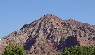
Church Rock is a census-designated place (CDP) in McKinley County, New Mexico, United States. The population was 1,128 at the 2010 census. Church Rock is named for Church Rock, a prominent natural landmark with the same name.

The Deschutes River in central Oregon is a major tributary of the Columbia River. The river provides much of the drainage on the eastern side of the Cascade Range in Oregon, gathering many of the tributaries that descend from the drier, eastern flank of the mountains. The Deschutes provided an important route to and from the Columbia for Native Americans for thousands of years, and then in the 19th century for pioneers on the Oregon Trail. The river flows mostly through rugged and arid country, and its valley provides a cultural heart for central Oregon. Today the river supplies water for irrigation and is popular in the summer for whitewater rafting and fishing.

The Little Colorado River is a tributary of the Colorado River in the U.S. state of Arizona, providing the principal drainage from the Painted Desert region. Together with its major tributary, the Puerco River, it drains an area of about 26,500 square miles (69,000 km2) in eastern Arizona and western New Mexico. Although it stretches almost 340 miles (550 km), only the headwaters and the lowermost reaches flow year-round. Between St. Johns and Cameron, most of the river is a wide, braided wash, only containing water after heavy snowmelt or flash flooding.

The Wupatki National Monument is a United States National Monument located in north-central Arizona, near Flagstaff. Rich in Native American ruins, the monument is administered by the National Park Service in close conjunction with the nearby Sunset Crater Volcano National Monument. Wupatki was listed on the National Register of Historic Places on October 15, 1966. The listing included three contributing buildings and 29 contributing structures on 35,253.2 acres (14,266.5 ha).

The San Juan River is a major tributary of the Colorado River in the Southwestern United States, providing the chief drainage for the Four Corners region of Colorado, New Mexico, Utah and Arizona. Originating as snowmelt in the San Juan Mountains of Colorado, it flows 383 miles (616 km) through the deserts of northern New Mexico and southeastern Utah to join the Colorado River at Glen Canyon. The river drains a high, arid region of the Colorado Plateau and along its length it is often the only significant source of fresh water for many miles. The San Juan is also one of the muddiest rivers in North America, carrying an average of 25 million US tons of silt and sediment each year.

The Colorado Plateau, also known as the Colorado Plateau Province, is a physiographic and desert region of the Intermontane Plateaus, roughly centered on the Four Corners region of the southwestern United States. This province covers an area of 336,700 km2 (130,000 mi2) within western Colorado, northwestern New Mexico, southern and eastern Utah, northern Arizona, and a tiny fraction in the extreme southeast of Nevada. About 90% of the area is drained by the Colorado River and its main tributaries: the Green, San Juan, and Little Colorado. Most of the remainder of the plateau is drained by the Rio Grande and its tributaries.

Northern Arizona is an unofficial, colloquially-defined region of the U.S. state of Arizona. Generally consisting of Coconino, Mohave, Navajo, and Apache counties, the region is geographically dominated by the Colorado Plateau, the southern border of which in Arizona is called the Mogollon Rim.
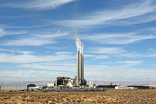
Navajo Generating Station was a 2.25-gigawatt, coal-fired power plant located on the Navajo Nation, near Page, Arizona United States. This plant provided electrical power to customers in Arizona, Nevada, and California. It also provided the power for pumping Colorado River water for the Central Arizona Project, supplying about 1.5 million acre feet (1.85 km3) of water annually to central and southern Arizona. As of 2017 permission to operate as a conventional coal-fired plant was anticipated until 2017-2019, and to December 22, 2044 if extended. However, in 2017, the utility operators of the power station voted to close the facility when the lease expires in 2019. In March 2019, the Navajo Nation ended efforts to buy the plant and continue running it after the lease expires.

Mount Taylor is a dormant stratovolcano in northwest New Mexico, northeast of the town of Grants. It is the high point of the San Mateo Mountains and the highest point in the Cibola National Forest. It was named in 1849 for then president Zachary Taylor. Prior to that, it was called Cebolleta by the Spanish; the name persists as one name for the northern portion of the San Mateo Mountains, a large mesa. Mount Taylor is largely forested with some meadows, rising above the desert below. The ancient caldera is heavily eroded to the east. Its slopes were an important source of lumber for neighboring pueblos.

The American Falls Dam is a concrete gravity-type dam located near the town of American Falls, Idaho, on river mile 714.7 of the Snake River. The dam and reservoir are a part of the Minidoka Project on the Snake River Plain and are used primarily for flood control, irrigation, and recreation. When the original dam was built by the Bureau of Reclamation, the residents of American Falls were forced to relocate three-quarters of their town to make room for the reservoir. A second dam was completed in 1978 and the original structure was demolished. Although the dam itself is located in Power County, its reservoir also stretches northeastward into both Bingham County and Bannock County.
The Moenkopi Formation is a geological formation that is spread across the U.S. states of New Mexico, northern Arizona, Nevada, southeastern California, eastern Utah and western Colorado. This unit is considered to be a group in Arizona. Part of the Colorado Plateau and Basin and Range, this red sandstone was laid down in the Lower Triassic and possibly part of the Middle Triassic, around 240 million years ago.

Uranium mining in Arizona has taken place since 1918. Prior to the uranium boom of the late 1940s, uranium in Arizona was a byproduct of vanadium mining of the mineral carnotite.
Osgood is an unincorporated community near Idaho Falls in Bonneville County, Idaho, United States. It is part of the Idaho Falls, Idaho Metropolitan Statistical Area.

The Snake River Plain ecoregion is a Level III ecoregion designated by the United States Environmental Protection Agency (EPA) in the U.S. states of Idaho and Oregon. It follows the Snake River across Idaho, stretching roughly 400 miles (640 km) from the Wyoming border to Eastern Oregon in the xeric intermontane west. Characterized by plains and low hills, it is considerably lower and less rugged than surrounding ecoregions. Many of the alluvial valleys bordering the Snake River are used for agriculture. Where irrigation water and soil depth are sufficient, sugar beets, potatoes, alfalfa, small grains, and vegetables are grown. Elsewhere, livestock grazing is widespread. Cattle feedlots and dairy operations are found locally.

The Return of Navajo Boy is a documentary film produced by Jeff Spitz and Bennie Klain about the Cly family, Navajo who live on their reservation. Through them, the film explores several longstanding issues among the Navajo and their relations with the United States government and corporations: environmental racism, white supremacy, media and political representation, off-reservation adoption, and denial of reparations for environmental illnesses due to uranium mining in Monument Valley, Utah, which was unregulated for decades. Bill Kennedy served as the film's executive producer; his late father had produced and directed the earlier silent film The Navajo Boy (1950s), which featured the Cly family.

The Church Rock uranium mill spill occurred in the U.S. state of New Mexico on July 16, 1979, when United Nuclear Corporation's tailings disposal pond at its uranium mill in Church Rock breached its dam. The accident remains the largest release of radioactive material in U.S. history, having released more radioactivity than the Three Mile Island accident four months earlier.

In 1944, uranium mining under the U.S military's Manhattan Project began on Navajo Nation lands and on Lakota Nation lands. On August 1, 1946, the responsibility for atomic science and technology was transferred from the military to the United States Atomic Energy Commission. Afterward, widespread uranium mining began on Navajo and Lakota lands in a nuclear arms race with the Soviet Union during the Cold War.

Bridge Canyon Dam, also called Hualapai Dam, was a proposed dam in the lower Grand Canyon of the Colorado River, in northern Arizona in the United States. It would have been located near Bridge Canyon Rapids in an extremely rugged and isolated portion of the canyon, 235 miles (378 km) downstream of Lee's Ferry and at the uppermost end of Lake Mead.

The Colorado River is a major river of the western United States and northwest Mexico in North America. Its headwaters are in the Rocky Mountains where La Poudre Pass Lake is its source. Located in north central Colorado it flows southwest through the Colorado Plateau country of western Colorado, southeastern Utah and northwestern Arizona where it flows through the Grand Canyon. It turns south near Las Vegas, Nevada, forming the Arizona–Nevada border in Lake Mead and the Arizona–California border a few miles below Davis Dam between Laughlin, Nevada and Needles, California before entering Mexico in the Colorado Desert. Most of its waters are diverted into the Imperial Valley of Southern California. In Mexico its course forms the boundary between Sonora and Baja California before entering the Gulf of California. This article describes most of the major features along the river.

