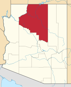
Dennison, Arizona

Last updated
Dennison, Arizona
Railroad stop
USA Arizona location map.svg
Red pog.svg
Dennison, Arizona
Location within the state of Arizona
Usa edcp location map.svg
Red pog.svg
Dennison, Arizona
Dennison, Arizona (the United States)
Coordinates: 35°05′12″N110°54′18″W / 35.08667°N 110.90500°W / 35.08667; -110.90500 Coordinates: 35°05′12″N110°54′18″W / 35.08667°N 110.90500°W / 35.08667; -110.90500
Country United States
State Arizona
County Coconino
Elevation
[1]
5,013 ft (1,528 m)
Time zone UTC-7 (Mountain (MST))
  Summer (DST) UTC-7 (MST)
Area code 928
FIPS code 04-18585
GNIS feature ID 24398

Dennison was a stop on the Atchison, Topeka and Santa Fe Railway between Canyon Diablo, and Winslow, Arizona, United States, in Coconino County. [2] Formerly in Yavapai County, [3] it came to be in Coconino County upon the latter's creation in 1891. [4] Dennison was named for a railroad roadmaster named Denny. [5]

Contents

It has an estimated elevation of 5,013 feet (1,528 m) above sea level. [1] [6] A short distance west of Dennison siding, the Kaibab Limestone that is predominant in the western part of the state first rises above the limestone Moenkopi Formation found to the east. [7]

In 1910, the railroad was double-tracked from Winslow, Arizona, to a point two miles west of Dennison. [8]

By 1972, Dennison was only a phone station on the railroad line. At that time, the name had fallen out of public use, and local landowners successfully petitioned the county to change the name of Dennison Road, exit 239 on Interstate 40, to Red Gap Ranch Road and Meteor City Road. [9]

Incidents

On 1 September 1891 two men were killed on the line between Dennison and Winslow when a wagon carrying blasting powder on a freight train exploded. [10]

On 28 March 1899, trackwalker George Smiley shot and killed Dennison section foreman, Paul McSweeney, following a dispute over unpaid wages. [11] Smiley was executed on 8 January the following year. [12]

On 1 July 1899 a light engine ran into the back of a freight train in the siding at Dennison, killing a brakeman and an engineer. [13]

Related Research Articles

<span class="mw-page-title-main">Coconino County, Arizona</span> County in Arizona, United States

Coconino County is a county in the north-central part of the U.S. state of Arizona. Its population was 145,101 at the 2020 census. The county seat is Flagstaff. The county takes its name from Cohonino, a name applied to the Havasupai people. It is the second-largest county by area in the contiguous United States, behind San Bernardino County, California. It has 18,661 sq mi (48,300 km2), or 16.4% of Arizona's total area, and is larger than each of the nine smallest states in the U.S.

<span class="mw-page-title-main">Holbrook, Arizona</span> City in Navajo County, Arizona, US

Holbrook is a city in Navajo County, Arizona, United States. According to the 2010 census, the population of the city was 5,053. The city is the county seat of Navajo County.

<span class="mw-page-title-main">U.S. Route 66 in Arizona</span> Former designated US highway in Arizona

U.S. Route 66 also known as the Will Rogers Highway, was a major United States Numbered Highway in the state of Arizona from November 11, 1926, to June 26, 1985. US 66 covered a total of 385.20 miles (619.92 km) through Arizona. The highway ran from west to east, starting in Needles, California, through Kingman and Seligman to the New Mexico state line. Nationally, US 66 ran from Santa Monica, California, to Chicago, Illinois. In its height of popularity, US 66 was one of the most popular highways in the state of Arizona, sometimes carrying over one million cars a year.

<span class="mw-page-title-main">Drake, Arizona</span> Unincorporated community in the state of Arizona, United States

Drake was an unincorporated community on the Verde River in Yavapai County, Arizona, United States, and a station on the BNSF Railway's Phoenix Subdivision. Drake is also the junction and western terminus of the Verde Canyon Railroad. Drake is the site of the old Hell Canyon Bridge, formerly used by US Route 89, and now on the National Register of Historic Places.

<span class="mw-page-title-main">Canyon Diablo, Arizona</span> Ghost town in Coconino County, Arizona

Canyon Diablo is a ghost town in Coconino County, Arizona, United States on the edge of the arroyo Canyon Diablo. The community was settled in 1880 and died out in the early 20th century.

<span class="mw-page-title-main">Chevelon Creek Bridge</span> Historic bridge in Arizona, U.S.

Chevelon Creek Bridge is a historic road bridge located about 12 miles (19 km) southeast of Winslow, in Navajo County, eastern Arizona, United States. It is a steel Warren Pony truss bridge over Chevelon Creek, built on the first permanent road connecting Holbrook, the seat of Navajo County, and Winslow. When built, the road was regionally important in northern Arizona as well as being a segment of an early national highway at the time automobile traffic was growing and national roads were first being formed. The bridge was listed on the National Register of Historic Places in 1983 for being a rare design in Arizona, part of an early transnational roadway, one of the first bridges built by Arizona after statehood in 1912, and being in nearly original condition.

<span class="mw-page-title-main">Perkinsville, Arizona</span> Ghost town in Yavapai County, Arizona

Perkinsville, Arizona, is a populated place in Yavapai County, in the U.S. state of Arizona. It is a hamlet about 0.5 miles (0.8 km) from the Perkinsville Bridge over the Verde River.

<span class="mw-page-title-main">Temple Butte</span> Landform in the Grand Canyon, Arizona

Temple Butte, in the Grand Canyon, Arizona, US is a prominence below the East Rim. The butte lies on the west bank of the south-flowing Colorado River. The outfall from the Little Colorado River, draining from the Painted Desert to the east and southeast, is about two miles upstream.

<span class="mw-page-title-main">Isis Temple</span> Landform in the Grand Canyon, Arizona

Isis Temple is a prominence in the Grand Canyon, Arizona, Southwestern United States. It is located below the North Rim and adjacent to the Granite Gorge along the Colorado River. The Trinity Creek and canyon flow due south at its west border; its north, and northeast border/flank is formed by Phantom Creek and canyon, a west tributary of Bright Angel Creek; the creeks intersect about 3 mi (4.8 km) southeast, and 1.0 mi (1.6 km) north of Granite Gorge. The Isis Temple prominence, is only about 202 ft (62 m) lower than Grand Canyon Village, the main public center on Grand Canyon’s South Rim.

<span class="mw-page-title-main">Edward M. Doe</span> American lawyer and judge (1850–1919)

Edward Madison Doe was an American jurist who served as an associate justice of the Arizona Territorial Supreme Court from 1909 till Arizona statehood in 1912.

Corva was a populated place situated in Coconino County, Arizona. It has an estimated elevation of 6,227 feet (1,898 m) above sea level.

Cosnino is a populated place situated in Coconino County, Arizona, United States, located several miles east of Flagstaff, the county seat.

Riordan was a populated place situated in Coconino County, Arizona, United States. It has an estimated elevation of 7,316 feet (2,230 m) above sea level.

<span class="mw-page-title-main">Twin Arrows, Arizona</span> Ghost town in Arizona, US

Twin Arrows is a ghost town located in the central part of Arizona on U.S. Route 66 (US 66) in Coconino County between the city of Flagstaff and the town of Winslow.

Anita was a mining town situated in Coconino County, Arizona on the Grand Canyon Railway. It was named in 1897 after a railroad surveyor's daughter.

Frank O. Mattox was an American politician from Arizona who served two terms in the Arizona State Legislature. His first term was in the 1st Arizona State Legislature, where he served in the state House of Representatives, as the sole representative from Navajo County. His second term was during the 3rd Arizona State Legislature, where he also represented Navajo County, but this time in the State Senate.

<span class="mw-page-title-main">W. A. Parr</span> American politician from Arizona

W. A. Parr was an American politician from Arizona. He served a single term in the Arizona State Senate during the 4th Arizona State Legislature, holding the seat from Navajo County. In addition, he served two terms in the Arizona Territorial Legislature, both in the lower house. He was a contractor and an undertaker.

W. A. "Art" Saunders was an American cattle rancher and politician from Arizona. He served a single term in the Arizona State Senate during the 5th Arizona State Legislature, holding the seat from Apache County. In addition, he served several years as a supervisor on the board of supervisors in Apache County, as well as the county surveyor in Navajo County.

References

  1. 1 2 "Feature Detail Report for: Dennison". Geographic Names Information System . United States Geological Survey, United States Department of the Interior.
  2. Map of the Twelfth Twenty Five Miles of the Western Division Atlantic and Pacific Rail Road from the 276th to the 300th Mile Twelfth Land Grant Section., Atlantic & Pacific Railroad Company, 1 December 1881
  3. Arizona. Tusyan Sheet 1:250000, USGS, 1886
  4. "County Division". The St. Johns Herald. 21 February 1889.
  5. Newton, Charles H. (1980). Place Names in Arizona. Primer Printers. p. 16. ISBN   9780935810240.
  6. William Bowie & H.G. Avers (1914). "Table of Elevations at Railroad Stations". Fourth General Adjustment of the Precise Level Net in the United States and the Resulting Standard Elevations. U.S. Coast and Geodetic Survey. p. 161.
  7. N. H. Barton; et al. (1915), United States Geological Survey, Bulletin 613, Guidebookof the Western United States: The Santa Fe Route With a Side Trip to the Grand Canyon (PDF), Department of the Interior, p. 112
  8. "Double Tracking Has Commenced". Holbrook Argus. February 8, 1910.
  9. "No. 72-11 Resolution". Arizona Daily Sun. May 13, 1972. p. 9.
  10. "Two Men Killed". The Coconino Sun. 5 Sep 1891. p. 2.
  11. "Arizona Day By Day". Arizona Republic. 3 Apr 1899. p. 3.
  12. "George Smiley Executed". Holbrook Argus. 13 Jan 1900. p. 5.
  13. "Wreck at Dennison". Las Vegas Daily Optic. 31 July 1899. p. 1.