Kaibab, Arizona

Last updated

Kaibab, Arizona
USA Arizona location map.svg
Red pog.svg
Kaibab
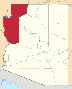
Location in Mohave County and the state of Arizona
Usa edcp location map.svg
Red pog.svg
Kaibab
Kaibab (the United States)
Coordinates: 36°54′46″N112°40′7″W / 36.91278°N 112.66861°W / 36.91278; -112.66861
CountryUnited States
State Arizona
County Mohave
Area
[1]
  Total6.46 sq mi (16.74 km2)
  Land6.46 sq mi (16.72 km2)
  Water0.01 sq mi (0.02 km2)
Elevation
4,991 ft (1,521 m)
Population
 (2020) [2]
  Total140
  Density21.69/sq mi (8.37/km2)
Time zone UTC-7 (MST)
ZIP code
86022
Area code 928
FIPS code 04-36500
GNIS feature ID 42814

Kaibab is an unincorporated community and census-designated place (CDP) in Mohave County, Arizona, United States. It is within the Kaibab Indian Reservation. The population of the CDP was 140 at the 2020 census. [2]

Contents

Geography

Kaibab is located in the northeast corner of Mohave County at 36°54′46″N112°40′7″W / 36.91278°N 112.66861°W / 36.91278; -112.66861 (36.912680, -112.668732). [3] Arizona State Route 389 forms the southern edge of the CDP; the highway leads northeast 13 miles (21 km) to Fredonia and northwest 18 miles (29 km) to Colorado City. The townsite of Kaibab is 3 miles (5 km) north of AZ 389 on Pipe Spring Road.

Pipe Spring National Monument is in the southwest corner of the CDP, close to AZ 389. The CDP is bordered to the north by the CDP of Moccasin. According to the United States Census Bureau, the Kaibab CDP has a total area of 6.4 square miles (16.7 km2), of which 0.01 square miles (0.02 km2), or 0.1%, is water. [1]

The townsite is located at a section of the Vermilion Cliffs and a southeast stretch of the Moccasin Mountains.

Demographics

Historical population
CensusPop.Note
2000 275
2010 124−54.9%
2020 14012.9%
U.S. Decennial Census [4]

As of the census [5] of 2000, there were 275 people, 88 households, and 69 families living in the CDP. The population density was 1.5 inhabitants per square mile (0.58/km2). There were 116 housing units at an average density of 0.6 per square mile (0.23/km2). The racial makeup of the CDP was 40% White, 53% Native American, 4% from other races, and 4% from two or more races. 8% of the population were Hispanic or Latino of any race. (Note: percentages do not total 100% because of rounding.)

There were 88 households, out of which 53% had children under the age of 18 living with them, 44% were married couples living together, 28% had a female householder with no husband present, and 21% were non-families. 19% of all households were made up of individuals, and 2% had someone living alone who was 65 years of age or older. The average household size was 3.1 and the average family size was 3.5.

In the CDP, the age distribution of the population shows 44% under the age of 18, 9% from 18 to 24, 23% from 25 to 44, 20% from 45 to 64, and 4% who were 65 years of age or older. The median age was 22 years. For every 100 females, there were 75.2 males. For every 100 females age 18 and over, there were 81.2 males.

The median income for a household in the CDP was $21,458, and the median income for a family was $22,679. Males had a median income of $25,313 versus $16,607 for females. The per capita income for the CDP was $9,421. About 27% of families and 30% of the population were below the poverty line, including 35% of those under the age of eighteen and none of those 65 or over.

Related Research Articles

<span class="mw-page-title-main">Mohave County, Arizona</span> County in Arizona, United States

Mohave County is in the northwestern corner of the U.S. state of Arizona. As of the 2020 census, its population was 213,267. The county seat is Kingman, and the largest city is Lake Havasu City. It is the fifth largest county in the United States.

<span class="mw-page-title-main">Parks, Arizona</span> CDP in Coconino County, Arizona

Parks is a census-designated place (CDP) in Coconino County, Arizona, United States. The population was 1,188 at the 2010 census.

<span class="mw-page-title-main">Parker Strip, Arizona</span> CDP in La Paz County, Arizona

Parker Strip is a census-designated place (CDP) in La Paz County, Arizona, United States. The population was 662 at the 2010 census.

<span class="mw-page-title-main">Poston, Arizona</span> CDP in La Paz County, Arizona

Poston is an unincorporated community and census-designated place (CDP) in La Paz County, Arizona, United States, in the Parker Valley. The population was 285 at the 2010 census, down from 389 in 2000.

<span class="mw-page-title-main">Arizona Village, Arizona</span> Census-designated place in Arizona, United States

Arizona Village is a census-designated place (CDP) on the Fort Mojave Indian Reservation in Mohave County, Arizona, United States. The population was 1,057 at the 2020 census, up from 946 in 2010 and 351 in 2000.

<span class="mw-page-title-main">Desert Hills, Arizona</span> CDP in Mohave County, Arizona

Desert Hills is an unincorporated community and census-designated place (CDP) in Mohave County, Arizona, United States. The population was 2,764 at the 2020 census, up from 2,245 at the 2010 census.

<span class="mw-page-title-main">Mesquite Creek, Arizona</span> CDP in Mohave County, Arizona

Mesquite Creek is an unincorporated community and census-designated place (CDP) in Mohave County, Arizona, United States. The population was 403 at the 2020 census.

<span class="mw-page-title-main">Mohave Valley, Arizona</span> CDP in Mohave County, Arizona

Mohave Valley is an unincorporated community and census-designated place (CDP) in Mohave County, Arizona, United States. The population was 2,693 at the 2020 census. It is geographically connected to Needles, California, Fort Mohave and Bullhead City.

<span class="mw-page-title-main">Mojave Ranch Estates, Arizona</span> CDP in Mohave County, Arizona

Mojave Ranch Estates is an unincorporated community and census-designated place (CDP) in Mohave County, Arizona, United States. The population was 53 as of the 2020 census.

<span class="mw-page-title-main">New Kingman-Butler, Arizona</span> CDP in Mohave County, Arizona

New Kingman-Butler is an unincorporated community and census-designated place (CDP) in Mohave County, Arizona, United States, directly north of and bordering the city of Kingman. The population was 12,907 as of the 2020 census.

<span class="mw-page-title-main">Peach Springs, Arizona</span> CDP in Mohave County, Arizona

Peach Springs is a census-designated place (CDP) in Mohave County, Arizona, United States. The population was 1,098 at the 2020 census. Peach Springs serves as the administrative headquarters of the Hualapai people and is located on the Hualapai Reservation.

<span class="mw-page-title-main">Willow Valley, Arizona</span> Census-designated place in Arizona, United States

Willow Valley is an unincorporated community and census-designated place (CDP) in Mohave County, Arizona, United States. The population was 1,059 as of the 2020 census.

<span class="mw-page-title-main">Pisinemo, Arizona</span> CDP in Pima County, Arizona

Pisinemo is a census-designated place (CDP) in Pima County, Arizona, United States. The population was 340 as of the 2020 census.

<span class="mw-page-title-main">Congress, Arizona</span> CDP in Yavapai County, Arizona

Congress is a census-designated place (CDP) in Yavapai County, Arizona, United States. Once a gold-mining center for the Congress Mine and then a ghost town, Congress now serves as a retirement and bedroom community for nearby Wickenburg. The population was 1,811 at the 2020 census.

<span class="mw-page-title-main">Paulden, Arizona</span> CDP in Yavapai County, Arizona

Paulden is a census designated place (CDP) in Yavapai County, Arizona, United States. The population was 5,231 at the 2010 census.

<span class="mw-page-title-main">Parc, New York</span> Census-designated place in New York, United States

Parc is a location and census-designated place in Clinton County, New York, United States. The name "Parc" is derived from the official name for the 3,447-acre (13.95 km2) industrial site, which is PARC, an acronym for the Plattsburgh Airbase Redevelopment Corporation. PARC was established for the purpose of redeveloping the Plattsburgh Air Force Base after it closed on September 25, 1995. PARC is now operated by the Plattsburgh Air Base Development Authority, and the massive airfield is now Plattsburgh International Airport. The population of the Parc CDP was 254 at the 2010 census. Parc is located in the town of Plattsburgh and is bordered to the north by the city of Plattsburgh.

<span class="mw-page-title-main">Kaibab Indian Reservation</span> Indian Reservation

The Kaibab Indian Reservation is the home of the Kaibab Band of Paiute Indians, a federally recognized tribe of Southern Paiutes. The Indian reservation is located in northern part of the U.S. state of Arizona. It covers a land area of 188.75 square miles (488.9 km2) in northeastern Mohave County and northwestern Coconino County adjacent to the southern Utah border. The Pipe Spring National Monument lies in the southwestern section of the reservation. The Thunder Mountain Pootseev Dark-sky preserve is colocated with the reservation.

Centennial Park is an unincorporated community and census-designated place (CDP) in Mohave County, Arizona, United States. The population was 1,578 at the 2020 census, up from 1,264 at the 2010 census. It is the central location for the Centennial Park group, a fundamentalist Mormon group.

<span class="mw-page-title-main">Brunswick (CDP), Maine</span> Census-designated place in Maine, United States

Brunswick is a census-designated place (CDP) in the town of Brunswick in Cumberland County, Maine, United States. The population was 15,175 at the 2010 census. It is part of the Portland–South Portland–Biddeford, Maine Metropolitan Statistical Area.

<span class="mw-page-title-main">Cane Beds, Arizona</span> Census-designated place in Arizona, United States

Cane Beds is an unincorporated community and census-designated place (CDP) in Mohave County, Arizona, United States. It lies 4 miles (6 km) south of the border with Utah in the Arizona Strip, and is supported by services in Utah as well as some in Nevada.

References

  1. 1 2 "2021 U.S. Gazetteer Files: Arizona". United States Census Bureau. Retrieved May 24, 2022.
  2. 1 2 "P1. Race – Kaibab CDP, Arizona: 2020 DEC Redistricting Data (PL 94-171)". U.S. Census Bureau. Retrieved May 24, 2022.
  3. "US Gazetteer files: 2010, 2000, and 1990". United States Census Bureau. February 12, 2011. Retrieved April 23, 2011.
  4. "Census of Population and Housing". Census.gov. Retrieved June 4, 2016.
  5. "U.S. Census website". United States Census Bureau . Retrieved January 31, 2008.