Moccasin, Arizona

Last updated

Moccasin, Arizona
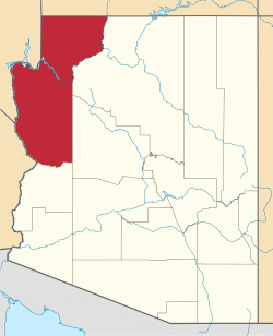
Mohave County Arizona Incorporated and Unincorporated areas Moccasin Highlighted 0447190.svg
Location in Mohave County, Arizona
USA Arizona location map.svg
Red pog.svg
Moccasin
Usa edcp location map.svg
Red pog.svg
Moccasin
Coordinates: 36°54′34″N112°45′32″W / 36.90944°N 112.75889°W / 36.90944; -112.75889
Country United States
State Arizona
County Mohave
Area
[1]
  Total0.77 sq mi (1.98 km2)
  Land0.77 sq mi (1.98 km2)
  Water0.00 sq mi (0.00 km2)
Elevation
5,092 ft (1,552 m)
Population
 (2020) [2]
  Total53
  Density69.19/sq mi (26.72/km2)
Time zone UTC-7 (Mountain (MST))
ZIP Code
86022 (Fredonia)
Area code 928
GNIS feature ID 8145
FIPS code 04-47190

Moccasin is an unincorporated community and census-designated place in Mohave County, Arizona, United States. It is within the Kaibab Indian Reservation, and its population was 53 as of the 2020 census, [2] down from 89 at the 2010 census. It is bordered to the south by the CDP of Kaibab.

It is believed a moccasin-shaped shoe-print by a nearby spring caused the name to be selected. [3] Sometime in the late 1800s.

Historical population
CensusPop.Note
2010 89
2020 53−40.4%
U.S. Decennial Census [4]

Related Research Articles

<span class="mw-page-title-main">Coconino County, Arizona</span> County in Arizona, United States

Coconino County is a county in the north-central part of the U.S. state of Arizona. Its population was 145,101 at the 2020 census. The county seat is Flagstaff. The county takes its name from Cohonino, a name applied to the Havasupai people. It is the second-largest county by area in the contiguous United States, behind San Bernardino County, California. It has 18,661 sq mi (48,300 km2), or 16.4% of Arizona's total area, and is larger than the nine smallest states in the U.S.

<span class="mw-page-title-main">Mohave County, Arizona</span> County in Arizona, United States

Mohave County is in the northwestern corner of the U.S. state of Arizona. As of the 2020 census, its population was 213,267. The county seat is Kingman, and the largest city is Lake Havasu City. It is the fifth largest county in the United States.

<span class="mw-page-title-main">Bitter Springs, Arizona</span> Census-designated place in Coconino County, Arizona

Bitter Springs is a native village and census-designated place (CDP) on the Navajo Nation in Coconino County, Arizona, United States. As of the 2020 census, the CDP population was 364

<span class="mw-page-title-main">Fredonia, Arizona</span> Community in Coconino County, Arizona

Fredonia is a town in Coconino County, Arizona, United States. As of the 2010 census it had a population of 1,314. Fredonia is the gateway to the North Rim of the Grand Canyon.

<span class="mw-page-title-main">Grand Canyon Village, Arizona</span> Town in Arizona, United States

Grand Canyon Village is a census-designated place (CDP) located on the South Rim of the Grand Canyon, in Coconino County, Arizona, United States. Its population was 2,004 at the 2010 Census. Located in Grand Canyon National Park, it is wholly focused on accommodating tourists visiting the canyon. Its origins trace back to the railroad completed from Williams, to the canyon's South Rim by the Santa Fe Railroad in 1901. Many of the structures in use today date from that period. The village contains numerous landmark buildings, and its historic core is a National Historic Landmark District, designated for its outstanding implementation of town design.

Kaibab is an unincorporated community and census-designated place (CDP) in Mohave County, Arizona, United States. It is within the Kaibab Indian Reservation. The population of the CDP was 140 at the 2020 census.

<span class="mw-page-title-main">Parks, Arizona</span> CDP in Coconino County, Arizona

Parks is a census-designated place (CDP) in Coconino County, Arizona, United States. The population was 1,188 at the 2010 census.

<span class="mw-page-title-main">Tusayan, Arizona</span> Community in Coconino County, Arizona

Tusayan is a town located in Coconino County, Arizona, United States. It was incorporated in 2010. A resort town near the south entrance to Grand Canyon National Park. The population was 558 at the 2010 census.

<span class="mw-page-title-main">Ash Fork, Arizona</span> CDP in Yavapai County, Arizona

Ash Fork is a census-designated place in Yavapai County, Arizona, United States. Its population was 396 at the 2010 U.S. Census, down from 457 in 2000.

<span class="mw-page-title-main">Arlington, Arizona</span> CDP in Maricopa County, Arizona

Arlington is an unincorporated community and census-designated place (CDP) in Maricopa County, Arizona, United States, located 43 miles (69 km) west of downtown Phoenix on old U.S 80. It follows the street numbering system of Phoenix. As of the 2020 census, the population was 150, down from 194 at the 2010 census.

<span class="mw-page-title-main">Kaibab Indian Reservation</span> Indian Reservation

The Kaibab Indian Reservation is the home of the Kaibab Band of Paiute Indians, a federally recognized tribe of Southern Paiutes. The Indian reservation is located in northern part of the U.S. state of Arizona. It covers a land area of 188.75 square miles (488.9 km2) in northeastern Mohave County and northwestern Coconino County adjacent to the southern Utah border. The Pipe Spring National Monument lies in the southwestern section of the reservation. The Thunder Mountain Pootseev Dark-sky preserve is colocated with the reservation.

<span class="mw-page-title-main">Fair Play, South Carolina</span> Census-designated place in South Carolina, United States

Fair Play is a census-designated place located in Oconee County in the U.S. state of South Carolina. A small portion of the CDP extends into Anderson County. As of the 2020 census, the population of Fair Play was 704.

Fredonia-Moccasin Unified School District is a school district headquartered in Fredonia, Arizona, United States. It was founded via the merger of Fredonia Elementary School District, Fredonia High School District, Moccasin School District, and Cane Beds School District in May 1974 as the state's first, and to date only ever, school district to cross county lines.

<span class="mw-page-title-main">Darling, Mississippi</span> CDP in Mississippi, United States

Darling is a census-designated place in Quitman County, Mississippi. Darling is located on Mississippi Highway 3, north of Marks. Per the 2020 Census, the population was 154.

<span class="mw-page-title-main">Kaka, Arizona</span> CDP in Maricopa County, Arizona

Kaka is a census-designated place (CDP) in Maricopa County, Arizona, United States, located in the Tohono O'odham Nation. The population was 83 at the 2020 census, down from 141 at the 2010 census.

<span class="mw-page-title-main">Cane Beds, Arizona</span> Census-designated place in Arizona, United States

Cane Beds is an unincorporated community and census-designated place (CDP) in Mohave County, Arizona, United States. It lies 4 miles (6 km) south of the border with Utah in the Arizona Strip, and is supported by services in Utah as well as some in Nevada.

Crozier is an unincorporated community and census-designated place (CDP) in Mohave County, Arizona, United States. The population was 21 at the 2020 census.

Greenehaven is an unincorporated community and census-designated place (CDP) in Coconino County, Arizona, United States. It is bordered to the east, west, and south by the city of Page and to the north by the state of Utah. It was first listed as a CDP prior to the 2020 census.

Kaibab Estates West is an unincorporated community and census-designated place (CDP) in Coconino County, Arizona, United States. It is bordered to the south by Yavapai County. It was first listed as a CDP prior to the 2020 census.

Prairiewood Village is an unincorporated community and census-designated place (CDP) in Brown County, South Dakota, United States. It was first listed as a CDP prior to the 2020 census. The CDP had a population of 303 at the 2020 census.

References

  1. "2021 U.S. Gazetteer Files: Arizona". United States Census Bureau. Retrieved May 24, 2022.
  2. 1 2 "P1. Race – Moccasin CDP, Arizona: 2020 DEC Redistricting Data (PL 94-171)". U.S. Census Bureau. Retrieved May 24, 2022.
  3. Moyer, Armond; Moyer, Winifred (1958). The Origins of Unusual Place-Names. Keystone Pub. Associates. p. 85.
  4. "Census of Population and Housing". Census.gov. Retrieved June 4, 2016.