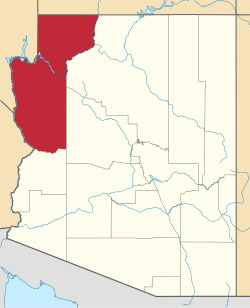
Scenic, Arizona | |
---|---|
Coordinates: 36°47′37″N114°00′46″W / 36.79361°N 114.01278°W | |
Country | United States |
State | Arizona |
County | Mohave |
Area | |
• Total | 16.45 sq mi (42.62 km2) |
• Land | 16.36 sq mi (42.37 km2) |
• Water | 0.10 sq mi (0.25 km2) |
Elevation | 1,791 ft (546 m) |
Population | |
• Total | 1,321 |
• Density | 80.75/sq mi (31.18/km2) |
Time zone | UTC-7 (MST) |
FIPS code | 04-64650 |
Scenic is an unincorporated community and census-designated place (CDP) in Mohave County in extreme northwestern Arizona, United States. [3] As of the 2020 census, its population was 1,321, [2] down from 1,643 in 2010. [4]
Scenic is located on the eastern side of the Nevada-Arizona state line from Mesquite, Nevada. The primary road access is from South Scenic Boulevard, which runs south from Highway 91 (the frontage road along the south side of Interstate 15).
Scenic is located within the Littlefield ZIP code of 86432. Residents from Scenic must either use the post office in Mesquite (ZIP code 89024) or in Beaver Dam. The Beaver Dam Post Office provides post office boxes for several small communities along the Virgin River and Interstate 15. These communities (all unincorporated) are Littlefield, Beaver Dam, Scenic, Arvada, and Desert Springs.
Scenic is within the Littlefield Unified School District, which is geographically the largest school district in Arizona.
Like all of the Arizona Strip area, Scenic is isolated from the rest of the state of Arizona due to its location north of the Grand Canyon and Colorado River. In order to drive to the rest of the state, one must drive either through Nevada or Utah or fly from the airports in Mesquite, Nevada or St. George, Utah.
The area is popular among many snowbirds who leave colder parts of the world to spend some time here to enjoy the environment, climate, and recreational opportunities.[ citation needed ] The area of Mesquite has a number of golf courses, parks and casinos, and is not far from Las Vegas. Other attractions include the Paiute Wilderness, Grand Canyon–Parashant National Monument and the Virgin River narrows and canyon.[ citation needed ]
Most properties are residential, but there are several businesses in the community, including the "Scenic General Store" at 2960 Scenic Blvd. The Mini-Storage and La Santisima Trinidad Catholic Church are part of the community. The Palms Golf Club, Mesquite Motocross Park, Oasis Gun Club, Staker Parson Companies, and Desert Skies Resort are in part of the Arvada, Arizona area. Most businesses use a post office box address in either Mesquite or Beaver Dam.
Census | Pop. | Note | %± |
---|---|---|---|
2010 | 1,643 | — | |
2020 | 1,321 | −19.6% | |
U.S. Decennial Census [5] |
The CDP is in the Littlefield Unified School District. [6]
Mohave County is a county in the northwestern corner of the U.S. state of Arizona. As of the 2020 census, its population was 213,267. The county seat is Kingman, and the largest city is Lake Havasu City. It is the fifth largest county in the United States.
Dolan Springs is an unincorporated community and census-designated place (CDP) in Mohave County, Arizona, United States. The population was 1,989 at the 2020 census, down from 2,033 at the 2010 census.
Golden Valley is an unincorporated area and census-designated place (CDP) in Mohave County, Arizona, United States, located halfway between Kingman and Bullhead City. The population was 8,801 at the 2020 census.
Mesquite Creek is an unincorporated community and census-designated place (CDP) in Mohave County, Arizona, United States. The population was 403 at the 2020 census.
Laughlin is an unincorporated community in Clark County, Nevada, United States. Laughlin lies 90 miles (140 km) south of Las Vegas, in the far southern tip of Nevada. As a resort town, it is known for its gaming and water recreation. As of the 2020 census, the population was 8,658. For statistical purposes, the United States Census Bureau has defined Laughlin as a census-designated place (CDP). It is located on the Colorado River, downstream from the Davis Dam and Lake Mohave, and directly across from the much larger Bullhead City, Arizona. The nearby communities of Bullhead City, Arizona; Needles, California; Fort Mohave, Arizona; and Mohave Valley, Arizona, bring the area's total population to about 100,000. Laughlin is also 286 miles (460 km) northeast of Los Angeles.
Littlefield is an unincorporated community and census-designated place in Mohave County, Arizona, United States, that is located in the Arizona Strip region. As of the 2020 census, its population was 256, a decline from the figure of 308 tabulated in 2010. It lies just south of Interstate 15, next to the Virgin River, approximately 10 miles (16 km) northeast of Mesquite, Nevada. Littlefield is located in the 86432 ZIP Code.
The Arizona Strip is the part of Arizona lying north of the Colorado River. Despite being larger in area than several U.S. states, the entire region has a population of fewer than 10,000 people. Consisting of northeastern Mohave County and northwestern Coconino County, the largest settlements in the Strip are Colorado City, Fredonia, and Beaver Dam, with smaller communities of Scenic, Littlefield and Desert Springs. The Kaibab Indian Reservation lies within the region. Lying along the North Rim of the Grand Canyon creates physical barriers to the rest of Arizona. Only three major roads traverse the region: I-15 crosses the northwestern corner, while Arizona State Route 389 and U.S. Route 89A cross the northeastern part of the strip, and US 89A crosses the Colorado River via the Navajo Bridge, providing the only direct road connection between the strip and the rest of the state. The nearest metropolitan area is the St. George, Utah metro area, to which the region is more connected than to the rest of Arizona.
Meadview is an unincorporated community and census-designated place (CDP) in Mohave County, Arizona, United States, located near Lake Mead. As of the 2020 census, Meadview had 1,420 residents, up from 1,224 as of 2010. It was founded in the 1960s as a retirement community and is still largely one, as well as a vacation spot for people coming to enjoy Lake Mead.
Littlefield Unified School District is a PK-12 grade school district headquartered in Beaver Dam, Arizona.
Beaver Dam is an unincorporated community and census-designated place (CDP) in Mohave County, Arizona, United States, that is located in the Arizona Strip region and was settled on December 2, 1863. It is located along Interstate 15 approximately 10 miles (16 km) northeast of Mesquite, Nevada. It is located in the 86432 ZIP Code. It had a population of 1,552 as of the 2020 census, a decline from the figure of 1,962 tabulated in 2010.
Interstate 15 (I-15) is an Interstate Highway, running from San Diego, California, United States, to the Canada–US border, through Mohave County in northwest Arizona. Despite being isolated from the rest of Arizona, in the remote Arizona Strip, and short in length at 29.43 miles (47.36 km), it remains notable for its scenic passage through the Virgin River Gorge. The highway heads in a northeasterly direction from the Nevada border northeast of Mesquite, Nevada, to the Utah border southwest of St. George, Utah.
Yucca is an unincorporated community and census-designated place (CDP) in Mohave County, Arizona, United States. As of the 2020 census it had a population of 96, down from 126 at the 2010 census.
Grand Canyon West is a census-designated place (CDP) in Mohave County, Arizona, United States, located on the Hualapai Reservation. The population was reported as 0 at the 2020 census. Grand Canyon West is home to the tribe's Grand Canyon business operations, including the Grand Canyon West Airport and the Grand Canyon Skywalk. Typically, they are open from 8:00 a.m. – 6:00 p.m., including all holidays.
Lupton is an unincorporated community and census-designated place (CDP) in Apache County, Arizona, United States. Lupton is located along Interstate 40 at the New Mexico border, 21 miles (34 km) southwest of Gallup, New Mexico. Lupton has a post office with ZIP code 86508. As of the 2010 census, the Lupton CDP had a population of 25.
Hackberry is an unincorporated community and census-designated place (CDP) in Mohave County, Arizona, United States. It is located on Arizona State Route 66 28 miles (45 km) northeast of Kingman. Hackberry has a post office which as of 2015 served 68 residential mailboxes with ZIP code 86411. As of the 2020 census, Hackberry had a population of 103.
Cane Beds is an unincorporated community and census-designated place (CDP) in Mohave County, Arizona, United States. It lies 4 miles (6 km) south of the border with Utah in the Arizona Strip, and is supported by services in Utah as well as some in Nevada.
Clacks Canyon is a census-designated place (CDP) in Mohave County, Arizona, United States. The population was 167 at the 2020 census.
Truxton is an unincorporated community and census-designated place (CDP) in Mohave County, in the U.S. state of Arizona. The population was 104 at the 2020 census, down from 134 in 2010.
Valle Vista is an unincorporated community and census-designated place (CDP) in Mohave County, in the U.S. state of Arizona. The population was 1,802 at the 2020 census.
Walnut Creek is an unincorporated community and census-designated place (CDP) in Mohave County, in the U.S. state of Arizona. The population was 571 at the 2020 census.