Valle Vista, Arizona

Last updated
Valle Vista, Arizona
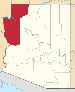
Mohave County Arizona Incorporated and Unincorporated areas Valle Vista Highlighted 0478865.svg
Location in Mohave County, Arizona
USA Arizona location map.svg
Red pog.svg
Valle Vista
Usa edcp location map.svg
Red pog.svg
Valle Vista
Coordinates: 35°24′39″N113°51′46″W / 35.41083°N 113.86278°W / 35.41083; -113.86278 Coordinates: 35°24′39″N113°51′46″W / 35.41083°N 113.86278°W / 35.41083; -113.86278
Country United States
State Arizona
County Mohave
Area
[1]
  Total11.96 sq mi (30.97 km2)
  Land11.96 sq mi (30.97 km2)
  Water0.00 sq mi (0.00 km2)
Population
 (2020) [2]
  Total1,802
  Density150.72/sq mi (58.19/km2)
Time zone UTC-7 (MST (no DST))
ZIP code
86401 [3]
Area code 928
FIPS code 04-78865

Valle Vista is an unincorporated community and census-designated place (CDP) in Mohave County, in the U.S. state of Arizona. [4] The population was 1,802 at the 2020 census. [2]

Contents

Geography

The community is in central Mohave County, 18 miles (29 km) northeast of Kingman, the county seat. It is on the north side of Arizona State Route 66, former U.S. Route 66.

Demographics

Historical population
CensusPop.
2010 1,659
2020 1,8028.6%
U.S. Decennial Census [5]

Related Research Articles

<span class="mw-page-title-main">Mohave County, Arizona</span> County in Arizona, United States

Mohave County is in the northwestern corner of the U.S. state of Arizona. As of the 2020 census, its population was 213,267. The county seat is Kingman, and the largest city is Lake Havasu City. It is the fifth largest county in the United States.

<span class="mw-page-title-main">Arizona Village, Arizona</span> Census-designated place in Arizona, United States

Arizona Village is a census-designated place (CDP) on the Fort Mojave Indian Reservation in Mohave County, Arizona, United States. The population was 1,057 at the 2020 census, up from 946 in 2010 and 351 in 2000.

<span class="mw-page-title-main">Desert Hills, Arizona</span> CDP in Mohave County, Arizona

Desert Hills is an unincorporated community and census-designated place (CDP) in Mohave County, Arizona, United States. The population was 2,764 at the 2020 census, up from 2,245 at the 2010 census.

<span class="mw-page-title-main">Mohave Valley, Arizona</span> CDP in Mohave County, Arizona

Mohave Valley is an unincorporated community and census-designated place (CDP) in Mohave County, Arizona, United States. The population was 2,693 at the 2020 census. It is geographically connected to Needles, California, Fort Mohave and Bullhead City.

<span class="mw-page-title-main">Mojave Ranch Estates, Arizona</span> CDP in Mohave County, Arizona

Mojave Ranch Estates is an unincorporated community and census-designated place (CDP) in Mohave County, Arizona, United States. The population was 53 as of the 2020 census.

<span class="mw-page-title-main">Peach Springs, Arizona</span> CDP in Mohave County, Arizona

Peach Springs is a census-designated place (CDP) in Mohave County, Arizona, United States. The population was 1,098 at the 2020 census. Peach Springs serves as the administrative headquarters of the Hualapai people and is located on the Hualapai Reservation.

<span class="mw-page-title-main">Willow Valley, Arizona</span> Census-designated place in Arizona, United States

Willow Valley is an unincorporated community and census-designated place (CDP) in Mohave County, Arizona, United States. The population was 1,059 as of the 2020 census.

<span class="mw-page-title-main">Oatman, Arizona</span> CDP in Mohave County, Arizona

Oatman is an unincorporated community and census-designated place (CDP) in the Black Mountains of Mohave County, Arizona, United States, located at an elevation of 2,710 feet (830 m). It began as a small mining camp when two prospectors struck a $10 million gold find in 1915, though the vicinity had already been settled for a number of years. Oatman's population grew to more than 3,500 in the course of a year. As of the 2020 census, its population was 102.

<span class="mw-page-title-main">Topock, Arizona</span> Unincorporated community in Arizona, United States

Topock is a small unincorporated community and census-designated place (CDP) in Mohave County, Arizona, United States. As of the 2020 census, the population within the CDP was 2. Topock and the surrounding region have a ZIP Code of 86436; in 2010, the population of the 86436 ZCTA was 2,104, almost all of whom live in the Golden Shores CDP to the north.

<span class="mw-page-title-main">Wikieup, Arizona</span> Unincorporated community in the state of Arizona, United States

Wikieup is an unincorporated community and census-designated place (CDP) located on U.S. Route 93 in Mohave County, Arizona, United States. It is located approximately 139 miles (224 km) northwest of Phoenix and 162 miles (261 km) southeast of Las Vegas. As of the 2020 census, the population of Wikieup was 135.

Centennial Park is an unincorporated community and census-designated place (CDP) in Mohave County, Arizona, United States. The population was 1,578 at the 2020 census, up from 1,264 at the 2010 census. It is the central location for the Centennial Park group, a fundamentalist Mormon group.

<span class="mw-page-title-main">Hackberry, Arizona</span> Unincorporated community in the state of Arizona, United States

Hackberry is an unincorporated community and census-designated place (CDP) in Mohave County, Arizona, United States. It is located on Arizona State Route 66 28 miles (45 km) northeast of Kingman. Hackberry has a post office which as of 2015 served 68 residential mailboxes with ZIP code 86411. As of the 2020 census, Hackberry had a population of 103.

<span class="mw-page-title-main">Valentine, Arizona</span> Unincorporated community in the state of Arizona, United States

Valentine is an unincorporated community and census-designated place (CDP) in Mohave County, Arizona, United States. As of the 2020 census it had a population of 39. Valentine is located on Arizona State Route 66 32 miles (51 km) northeast of Kingman. The majority of Valentine is located in a geographically isolated portion of the Hualapai Reservation.

<span class="mw-page-title-main">Antares, Arizona</span> Census-designated place in Arizona, United States

Antares is an unincorporated community and census designated place (CDP) in Mohave County, Arizona, United States. As of the 2020 census, it had a population of 132. It exists along part of historic U.S. Route 66.

Crozier is an unincorporated community and census-designated place (CDP) in Mohave County, Arizona, United States. The population was 21 at the 2020 census.

Crystal Beach is an unincorporated community and census-designated place (CDP) in Mohave County, Arizona, United States. The population was 250 at the 2020 census.

Pine Lake is an unincorporated community and census-designated place (CDP) in Mohave County, Arizona, United States. The population was 142 at the 2020 census.

So-Hi is an unincorporated community and census-designated place in Mohave County, in the U.S. state of Arizona. The population was 428 at the 2020 census, down from 477 in 2010.

<span class="mw-page-title-main">Truxton, Arizona</span> Census-designated place in Arizona, United States

Truxton is an unincorporated community and census-designated place (CDP) in Mohave County, in the U.S. state of Arizona. The population was 104 at the 2020 census, down from 134 in 2010.

<span class="mw-page-title-main">Walnut Creek, Arizona</span> Census-designated place in Arizona, United States

Walnut Creek is an unincorporated community and census-designated place (CDP) in Mohave County, in the U.S. state of Arizona. The population was 571 at the 2020 census.

References

  1. "2021 U.S. Gazetteer Files: Arizona". United States Census Bureau. Retrieved May 26, 2022.
  2. 1 2 "P1. Race – Valle Vista CDP, Arizona: 2020 DEC Redistricting Data (PL 94-171)". U.S. Census Bureau. Retrieved May 26, 2022.
  3. "Valle Vista ZIP Code". zipdatamaps.com. 2023. Retrieved January 12, 2023.
  4. U.S. Geological Survey Geographic Names Information System: Valle Vista, Arizona
  5. "Census of Population and Housing". Census.gov. Retrieved June 4, 2016.