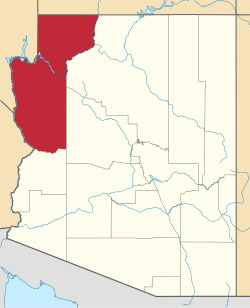
So-Hi, Arizona

Last updated

So-Hi, Arizona
USA Arizona location map.svg
Red pog.svg
So-Hi
Usa edcp location map.svg
Red pog.svg
So-Hi
Coordinates: 35°15′02″N114°08′29″W / 35.25056°N 114.14139°W / 35.25056; -114.14139
Country United States
State Arizona
County Mohave
Area
[1]
  Total
0.88 sq mi (2.27 km2)
  Land0.88 sq mi (2.27 km2)
  Water0.00 sq mi (0.00 km2)
Elevation
[2]
3,452 ft (1,052 m)
Population
 (2020) [3]
  Total
428
  Density488.58/sq mi (188.70/km2)
Time zone UTC-7 (MST (no DST))
FIPS code 04-67920
GNIS feature ID2582867 [2]

So-Hi is an unincorporated community and census-designated place in Mohave County, in the U.S. state of Arizona. The population was 428 at the 2020 census, [3] down from 477 in 2010. [4]

Contents

Geography

So-Hi is in central Mohave County, 8 miles (13 km) northwest of Kingman, the county seat. U.S. Route 93 runs past the south end of the community, leading southeast into Kingman and northwest 100 miles (160 km) to Las Vegas, Nevada.

Demographics

Historical population
CensusPop.Note
2010 477
2020 428−10.3%
U.S. Decennial Census [5]

Education

The CDP is in the Kingman Unified School District. [6]

References

  1. "2021 U.S. Gazetteer Files: Arizona". United States Census Bureau. Retrieved May 26, 2022.
  2. 1 2 U.S. Geological Survey Geographic Names Information System: So-Hi, Arizona
  3. 1 2 "P1. Race – So-Hi CDP, Arizona: 2020 DEC Redistricting Data (PL 94-171)". U.S. Census Bureau. Retrieved May 26, 2022.
  4. "2010 Census Gazetteer Files – Places: New Mexico". U.S. Census Bureau . Retrieved February 26, 2017.
  5. "Census of Population and Housing". Census.gov. Retrieved June 4, 2016.
  6. "2020 CENSUS - SCHOOL DISTRICT REFERENCE MAP: Mohave County, AZ" (PDF). U.S. Census Bureau. p. 3 (PDF p. 4/4). Retrieved October 4, 2024. - Text list