Mojave Ranch Estates, Arizona

Last updated

Mojave Ranch Estates
Mohave County Incorporated and Unincorporated areas Mohave Ranch Estates highlighted.svg
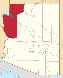
Location in Mohave County and the state of Arizona
USA Arizona location map.svg
Red pog.svg
Mojave Ranch Estates
Usa edcp location map.svg
Red pog.svg
Mojave Ranch Estates
Coordinates: 34°56′59″N114°35′37″W / 34.94972°N 114.59361°W / 34.94972; -114.59361
Country United States
State Arizona
County Mohave
Area
[1]
  Total0.75 sq mi (1.94 km2)
  Land0.75 sq mi (1.94 km2)
  Water0.00 sq mi (0.00 km2)
Elevation
473 ft (144 m)
Population
 (2020) [2]
  Total53
  Density70.86/sq mi (27.35/km2)
Time zone UTC-7 (MST)
ZIP code
86440 [3]
Area code 928
FIPS code 04-47495
GNIS feature ID 1853163

Mojave Ranch Estates is an unincorporated community and census-designated place (CDP) in Mohave County, Arizona, United States. The population was 53 as of the 2020 census. [2]

Contents

Geography

Mojave Ranch Estates is in western Mohave County at 34°56′59″N114°35′37″W / 34.94972°N 114.59361°W / 34.94972; -114.59361 (34.949652, -114.593489). [4] It is bordered to the south by the CDP of Mohave Valley. Arizona State Route 95 forms the western edge of the CDP; it leads north 15 miles (24 km) to Bullhead City and south 7 miles (11 km) to Needles, California, across the Colorado River.

According to the United States Census Bureau, the CDP has a total area of 0.7 square miles (1.8 km2), all land. [1]

Demographics

Historical population
CensusPop.Note
2000 28
2010 5285.7%
2020 531.9%
U.S. Decennial Census [5]

As of the census [6] of 2000, there were 28 people, 6 households, and 6 families living in the CDP. The population density was 37.7 inhabitants per square mile (14.6/km2). There were 6 housing units at an average density of 8.1 per square mile (3.1/km2). The racial makeup of the CDP was 46% White, 25% Native American, 15% from other races, and 14% from two or more races. 79% of the population were Hispanic or Latino of any race.

There were 6 households, out of which 100% had children under the age of 18 living with them, 83% were married couples living together, and 17% had a female householder with no husband present. No households were made up of individuals, and none had someone living alone who was 65 years of age or older. The average household size was 4.7 and the average family size was 4.7.

In the CDP, the population was spread out, with 43% under the age of 18, 11% from 18 to 24, 25% from 25 to 44, and 21% from 45 to 64. The median age was 22 years. For every 100 females, there were 64.7 males. For every 100 females age 18 and over, there were 100.0 males.

The median income for a household in the CDP was $42,917, and the median income for a family was $42,917. Males had a median income of $11,786 versus $17,188 for females. The per capita income for the CDP was $8,359. None of the population and none of the families were below the poverty line.

Related Research Articles

<span class="mw-page-title-main">Mohave County, Arizona</span> County in Arizona, United States

Mohave County is in the northwestern corner of the U.S. state of Arizona. As of the 2020 census, its population was 213,267. The county seat is Kingman, and the largest city is Lake Havasu City. It is the fifth largest county in the United States.

Kaibab is an unincorporated community and census-designated place (CDP) in Mohave County, Arizona, United States. It is within the Kaibab Indian Reservation. The population of the CDP was 140 at the 2020 census.

<span class="mw-page-title-main">Cibola, Arizona</span> CDP in La Paz County, Arizona

Cibola is a census-designated place (CDP) in La Paz County, Arizona, United States. The population was 250 at the 2010 census, up from 172 in 2000. It is named for the famed city of gold of the same name.

<span class="mw-page-title-main">Parker Strip, Arizona</span> CDP in La Paz County, Arizona

Parker Strip is a census-designated place (CDP) in La Paz County, Arizona, United States. The population was 662 at the 2010 census.

<span class="mw-page-title-main">Poston, Arizona</span> CDP in La Paz County, Arizona

Poston is an unincorporated community and census-designated place (CDP) in La Paz County, Arizona, United States, in the Parker Valley. The population was 285 at the 2010 census, down from 389 in 2000.

<span class="mw-page-title-main">Arizona Village, Arizona</span> Census-designated place in Arizona, United States

Arizona Village is a census-designated place (CDP) on the Fort Mojave Indian Reservation in Mohave County, Arizona, United States. The population was 1,057 at the 2020 census, up from 946 in 2010 and 351 in 2000.

<span class="mw-page-title-main">Desert Hills, Arizona</span> CDP in Mohave County, Arizona

Desert Hills is an unincorporated community and census-designated place (CDP) in Mohave County, Arizona, United States. The population was 2,764 at the 2020 census, up from 2,245 at the 2010 census.

<span class="mw-page-title-main">Golden Valley, Arizona</span> CDP in Mohave County, Arizona

Golden Valley is an unincorporated area and census-designated place (CDP) in Mohave County, Arizona, United States. The population was 8,801 at the 2020 census.

<span class="mw-page-title-main">Mesquite Creek, Arizona</span> CDP in Mohave County, Arizona

Mesquite Creek is an unincorporated community and census-designated place (CDP) in Mohave County, Arizona, United States. The population was 403 at the 2020 census.

<span class="mw-page-title-main">Mohave Valley, Arizona</span> CDP in Mohave County, Arizona

Mohave Valley is an unincorporated community and census-designated place (CDP) in Mohave County, Arizona, United States. The population was 2,693 at the 2020 census. It is geographically connected to Needles, California, Fort Mohave and Bullhead City.

<span class="mw-page-title-main">New Kingman-Butler, Arizona</span> CDP in Mohave County, Arizona

New Kingman-Butler is an unincorporated community and census-designated place (CDP) in Mohave County, Arizona, United States, directly north of and bordering the city of Kingman. The population was 12,907 as of the 2020 census.

<span class="mw-page-title-main">Willow Valley, Arizona</span> Census-designated place in Arizona, United States

Willow Valley is an unincorporated community and census-designated place (CDP) in Mohave County, Arizona, United States. The population was 1,059 as of the 2020 census.

<span class="mw-page-title-main">Palmyra, Utah</span> CDP in Utah, United States

Palmyra is a census-designated place (CDP) in Utah County, Utah, United States. It is part of the Provo–Orem Metropolitan Statistical Area. The population was 491 at the 2010 census. Palmyra is located directly west of Springville and northwest of Spanish Fork.

Clacks Canyon is a census-designated place (CDP) in Mohave County, Arizona, United States. The population was 167 at the 2020 census.

Crystal Beach is an unincorporated community in Mohave County, Arizona, United States. The population was 250 at the 2020 census. For statistical purposes, the United States Census Bureau has defined Crystal Beach as a census-designated place (CDP).

Golden Shores is a census-designated place (CDP) in Mohave County, Arizona, United States. The population was 1,927 at the 2020 census. Residents are part of the 86436 ZIP code area, with a mailing address of Topock.

Katherine is an unincorporated community and census-designated place (CDP) in Mohave County, Arizona, United States. The population was 76 at the 2020 census, down from 103 at the 2010 census.

Lazy Y U is an unincorporated community and census-designated place (CDP) in Mohave County, Arizona, United States. The population was 474 at the 2020 census, up from 428 at the 2010 census.

McConnico is an unincorporated community and census-designated place (CDP) in Mohave County, Arizona, United States. The population was 63 at the 2020 census.

Pinion Pines is an unincorporated community and census-designated place (CDP) in Mohave County, Arizona, United States. The population was 158 at the 2020 census.

References

  1. 1 2 "2021 U.S. Gazetteer Files: Arizona". United States Census Bureau. Retrieved May 24, 2022.
  2. 1 2 "P1. Race – Mojave Ranch Estates CDP, Arizona: 2020 DEC Redistricting Data (PL 94-171)". U.S. Census Bureau. Retrieved May 24, 2022.
  3. "Mojave Ranch Estates AZ ZIP Code". zipdatamaps.com. 2023. Retrieved May 3, 2023.
  4. "US Gazetteer files: 2010, 2000, and 1990". United States Census Bureau. February 12, 2011. Retrieved April 23, 2011.
  5. "Census of Population and Housing". Census.gov. Retrieved June 4, 2016.
  6. "U.S. Census website". United States Census Bureau . Retrieved January 31, 2008.