Mohave Valley, Arizona

Last updated

Mohave Valley, Arizona
Mohave Valley.jpg
Mohave County Incorporated and Unincorporated areas Mohave Valley highlighted.svg
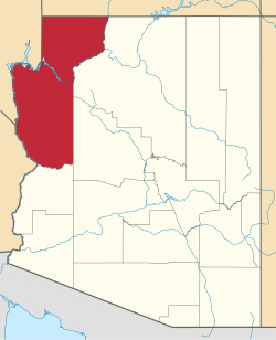
Location in Mohave County and the state of Arizona
USA Arizona location map.svg
Red pog.svg
Mohave Valley
Usa edcp location map.svg
Red pog.svg
Mohave Valley
Coordinates: 34°57′25″N114°35′5″W / 34.95694°N 114.58472°W / 34.95694; -114.58472
Country United States
State Arizona
County Mohave
Area
[1]
  Total14.04 sq mi (36.36 km2)
  Land14.02 sq mi (36.32 km2)
  Water0.02 sq mi (0.04 km2)
Elevation
523 ft (159 m)
Population
 (2020) [2]
  Total2,693
  Density192.06/sq mi (74.15/km2)
Time zone UTC-7 (MST)
ZIP codes
86440, 86446
Area code 928
FIPS code 04-47400
GNIS feature ID 1866989

Mohave Valley ('Amat' 'Analy Uuhwely [3] in Mojave) is an unincorporated community and census-designated place (CDP) in Mohave County, Arizona, United States. The population was 2,693 at the 2020 census. [2] It is geographically connected to Needles, California, Fort Mohave and Bullhead City.

Contents

History

The first recorded European to come through Mohave Valley was Melchor Díaz. He documented his travels in what is now northwestern Mohave County in 1540. [4] He recounts meeting a large population of natives who referred to themselves as the Pipa Aha Macav, meaning "People by the River". [5] From "Aha Macav" came the shortened name "Mojave" (also spelled "Mohave"). While Mohave Valley and Mohave County use the modern English spelling, the tribe retains the traditional Spanish spelling "Mojave". Both are correct, and both are pronounced "Moh-hah-vee". [6] [7]

Geography

Mohave Valley is located in western Mohave County at 34°57′25″N114°35′5″W / 34.95694°N 114.58472°W / 34.95694; -114.58472 (34.956929, -114.584613), [8] in the valley of the same name, drained by the Colorado River. The CDP is on the east side of Arizona State Route 95, which leads 3 miles (5 km) north to Fort Mohave, 16 miles (26 km) north to Bullhead City, and 6 miles (10 km) south to Needles, California, across the Colorado River. The Mohave Valley CDP is bordered to the south by Arizona Village, to the west by Willow Valley, and to the north by Mohave Ranch Estates, all CDPs.

According to the United States Census Bureau, the Mohave Valley CDP has a total area of 14.0 square miles (36 km2), of which 0.02 square miles (0.05 km2), or 0.11%, are water. [1]

Demographics

Historical population
CensusPop.Note
1990 6,962
2000 13,69496.7%
2010 2,616−80.9%
2020 2,6932.9%
[9]

As of the census [10] of 2000, there were 13,694 people, 5,217 households, and 3,850 families residing in the CDP. The population density was 302.6 inhabitants per square mile (116.8/km2). There were 6,672 housing units at an average density of 147.4 per square mile (56.9/km2). The racial makeup of the CDP was 90.8% White, 0.5% Black or African American, 2.3% Native American, 0.9% Asian, 0.1% Pacific Islander, 3.3% from other races, and 2.1% from two or more races. 12.0% of the population were Hispanic or Latino of any race.

There were 5,217 households, out of which 29.6% had children under the age of 18 living with them, 59.4% were married couples living together, 9.1% had a female householder with no husband present, and 26.2% were non-families. 19.0% of all households were made up of individuals, and 8.1% had someone living alone who was 65 years of age or older. The average household size was 2.61 and the average family size was 2.94.

In the CDP, the population was spread out, with 24.6% under the age of 18, 5.7% from 18 to 24, 25.8% from 25 to 44, 27.4% from 45 to 64, and 16.5% who were 65 years of age or older. The median age was 41 years. For every 100 females, there were 101.9 males. For every 100 females age 18 and over, there were 100.9 males.

The median income for a household in the CDP was $34,321, and the median income for a family was $38,897. Males had a median income of $29,719 versus $21,271 for females. The per capita income for the CDP was $16,287. About 7.9% of families and 11.0% of the population were below the poverty line, including 15.5% of those under age 18 and 6.1% of those age 65 or over.

Agriculture

Agriculture constitutes a major portion of Mohave Valley's economy. Main crops are cotton and alfalfa. [11]

Education

The CDP is in the Mohave Valley Elementary School District and the Colorado River Union High School District. [12]

High school students attend River Valley High School in the Colorado River Union High School District and also have the option to attend the Academy of Building Industries Public Charter High School located in Fort Mohave, Arizona, or the Aha Macav High School on the Fort Mojave Indian Reservation. [13]

See also

Related Research Articles

<span class="mw-page-title-main">Mohave people</span> Indigenous people to the Colorado River in the Mojave Desert

Mohave or Mojave are a Native American people indigenous to the Colorado River in the Mojave Desert. The Fort Mojave Indian Reservation includes territory within the borders of California, Arizona, and Nevada. The Colorado River Indian Reservation includes parts of California and Arizona and is shared by members of the Chemehuevi, Hopi, and Navajo peoples.

<span class="mw-page-title-main">Mohave County, Arizona</span> County in Arizona, United States

Mohave County is a county in the northwestern corner of the U.S. state of Arizona. As of the 2020 census, its population was 213,267. The county seat is Kingman, and the largest city is Lake Havasu City. It is the fifth largest county in the United States.

<span class="mw-page-title-main">Poston, Arizona</span> CDP in La Paz County, Arizona

Poston is an unincorporated community and census-designated place (CDP) in La Paz County, Arizona, United States, in the Parker Valley. The population was 285 at the 2010 census, down from 389 in 2000.

<span class="mw-page-title-main">Arizona Village, Arizona</span> Census-designated place in Arizona, United States

Arizona Village is a census-designated place (CDP) on the Fort Mojave Indian Reservation in Mohave County, Arizona, United States. The population was 1,057 at the 2020 census, up from 946 in 2010 and 351 in 2000.

<span class="mw-page-title-main">Bullhead City, Arizona</span> City in Mohave County, Arizona

Bullhead City is a city located on the Colorado River in Mohave County, Arizona, United States, 97 miles (156 km) south of Las Vegas, Nevada, and directly across the Colorado River from Laughlin, Nevada, whose casinos and ancillary services supply much of the employment for Bullhead City. Bullhead City is located at the southern end of Lake Mohave.

<span class="mw-page-title-main">Desert Hills, Arizona</span> CDP in Mohave County, Arizona

Desert Hills is an unincorporated community and census-designated place (CDP) in Mohave County, Arizona, United States. The population was 2,764 at the 2020 census, up from 2,245 at the 2010 census.

<span class="mw-page-title-main">Golden Valley, Arizona</span> CDP in Mohave County, Arizona

Golden Valley is an unincorporated area and census-designated place (CDP) in Mohave County, Arizona, United States, located halfway between Kingman and Bullhead City. The population was 8,801 at the 2020 census.

<span class="mw-page-title-main">Mesquite Creek, Arizona</span> CDP in Mohave County, Arizona

Mesquite Creek is an unincorporated community and census-designated place (CDP) in Mohave County, Arizona, United States. The population was 403 at the 2020 census.

<span class="mw-page-title-main">Mojave Ranch Estates, Arizona</span> CDP in Mohave County, Arizona

Mojave Ranch Estates is an unincorporated community and census-designated place (CDP) in Mohave County, Arizona, United States. The population was 53 as of the 2020 census.

<span class="mw-page-title-main">Willow Valley, Arizona</span> Census-designated place in Arizona, United States

Willow Valley is an unincorporated community and census-designated place (CDP) in Mohave County, Arizona, United States. The population was 1,059 as of the 2020 census.

<span class="mw-page-title-main">Laughlin, Nevada</span> Unincorporated community in the state of Nevada, United States

Laughlin is an unincorporated community in Clark County, Nevada, United States. Laughlin lies 90 miles (140 km) south of Las Vegas, in the far southern tip of Nevada. As a resort town, it is known for its gaming and water recreation. As of the 2020 census, the population was 8,658. For statistical purposes, the United States Census Bureau has defined Laughlin as a census-designated place (CDP). It is located on the Colorado River, downstream from the Davis Dam and Lake Mohave, and directly across from the much larger Bullhead City, Arizona. The nearby communities of Bullhead City, Arizona; Needles, California; Fort Mohave, Arizona; and Mohave Valley, Arizona, bring the area's total population to about 100,000. Laughlin is also 286 miles (460 km) northeast of Los Angeles.

<span class="mw-page-title-main">Fort Mojave Indian Reservation</span> Indian reservation in United States, Fort Mojave

The Fort Mohave Indian Reservation is an Indian reservation along the Colorado River, currently encompassing 23,669 acres (95.79 km2) in Arizona, 12,633 acres (51.12 km2) in California, and 5,582 acres (22.59 km2) in Nevada. The reservation is home to approximately 1,100 members of the federally recognized Fort Mojave Indian Tribe of Arizona, California, and Nevada, a federally recognized tribe of Mohave people.

<span class="mw-page-title-main">Mohave Valley</span> Landform along the Colorado River in Arizona

The Mohave Valley is a valley located mostly on the east shore of the south-flowing Colorado River in northwest Arizona. The valley extends into California's San Bernardino County; the northern side of the valley extends into extreme southeast Clark County, Nevada. The main part of the valley lies in southwest Mohave County, Arizona and is at the intersection of the southeast Mojave and northwest Sonoran deserts.

<span class="mw-page-title-main">Topock, Arizona</span> Unincorporated community in Arizona, United States

Topock is a small unincorporated community and census-designated place (CDP) in Mohave County, Arizona, United States. As of the 2020 census, the population within the CDP was 2. Topock and the surrounding region have a ZIP Code of 86436; in 2010, the population of the 86436 ZCTA was 2,104, almost all of whom live in the Golden Shores CDP to the north.

<span class="mw-page-title-main">Grand Canyon West, Arizona</span> Census-designated place in Arizona, United States

Grand Canyon West is a census-designated place (CDP) in Mohave County, Arizona, United States, located on the Hualapai Reservation. The population was reported as 0 at the 2020 census. Grand Canyon West is home to the tribe's Grand Canyon business operations, including the Grand Canyon West Airport and the Grand Canyon Skywalk. Typically, they are open from 8:00 a.m. – 6:00 p.m., including all holidays.

Mohave City is a ghost town in Mohave County in the northwestern part of the U.S. state of Arizona. Settled in the 1860s, in what was then the Arizona Territory, it was founded as a river landing and trading center for area miners and soldiers, and was named for Mohave County.

<span class="mw-page-title-main">Fort Mohave</span> United States historic place

Fort Mohave was originally named Camp Colorado when it was established on April 19, 1859 by Lieutenant Colonel William Hoffman during the Mohave War. It was located on the east bank of the Colorado River, at Beale's Crossing, near the head of the Mohave Valley in Mohave County, Arizona by the recommendation of Lieutenant Edward Fitzgerald Beale. After the end of the Indian Wars, the fort was transferred to the Bureau of Indian Affairs in 1890. In 1935 it was transferred to the Fort Mojave Indian Reservation; the fort is administered by the state of Arizona.

<span class="mw-page-title-main">Fort Mohave, Arizona</span> Census-designated place in Arizona, United States

Fort Mohave is an unincorporated community and census-designated place in Mohave County, Arizona, United States. It is named for a nearby fort that was used during the Mohave War. As of the 2020 census, the population of Fort Mohave was 16,190, up from 14,364 in 2010 and 8,919 in 2000. It is a suburb of Bullhead City. Its recent growth has made it the most populous unincorporated community in Mohave County.

Golden Shores is a census-designated place (CDP) in Mohave County, Arizona, United States. The population was 1,927 at the 2020 census. Residents are part of the 86436 ZIP code area, with a mailing address of Topock.

Katherine is an unincorporated community and census-designated place (CDP) in Mohave County, Arizona, United States. The population was 76 at the 2020 census, down from 103 at the 2010 census.

References

  1. 1 2 "2021 U.S. Gazetteer Files: Arizona". United States Census Bureau. Retrieved May 24, 2022.
  2. 1 2 "P1. Race – Mohave Valley CDP, Arizona: 2020 DEC Redistricting Data (PL 94-171)". U.S. Census Bureau. Retrieved May 24, 2022.
  3. Munro, P et al. A Mojave Dictionary Los Angeles: UCLA, 1992
  4. "New Mexico Office of the State Historian: Diaz, Melchior". Newmexicohistory.org. Archived from the original on October 10, 2013. Retrieved January 6, 2012.
  5. "About Us | Fort Mojave Indian Tribe". Mojaveindiantribe.com. December 5, 2010. Retrieved January 6, 2012.
  6. "Mojave | Define Mojave at Dictionary.com". Dictionary.reference.com. Retrieved January 6, 2012.
  7. "Mojave Indian". Mojave Indian. May 2, 2003. Retrieved January 6, 2012.
  8. "US Gazetteer files: 2010, 2000, and 1990". United States Census Bureau. February 12, 2011. Retrieved April 23, 2011.
  9. Populations have varied greatly due to changing delineations of the CDP. "Census of Population and Housing (1790–2000)". U.S. Census Bureau . Retrieved July 17, 2010.
  10. "U.S. Census website". United States Census Bureau . Retrieved January 31, 2008.
  11. "Arizona State and County Data" (PDF). 2007 Census of Agriculture. United States Department of Agriculture. pp. 252–253. Retrieved February 15, 2012.
  12. "2020 CENSUS - SCHOOL DISTRICT REFERENCE MAP: Mohave County, AZ" (PDF). U.S. Census Bureau. p. 3 (PDF p. 4/4). Retrieved October 4, 2024. - Text list
  13. "Aha Macav High School | Fort Mojave Indian Tribe" . Retrieved October 15, 2021.