
Franconia is a region of Germany, characterised by its culture and Franconian dialect.

Franconia Township is a township in Chisago County, Minnesota, United States. The population was 1,805 at the 2010 census, up from 1,128 in 2000. The township is home to the Franconia Sculpture Park.

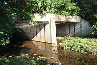
Franconia is a town in Grafton County, New Hampshire, United States. The population was 1,083 at the 2020 census. Set in the White Mountains, Franconia is home to the northern half of Franconia Notch State Park. Parts of the White Mountain National Forest are in the eastern and southern portions of the town. The Appalachian Trail crosses the town.
Franconia Township is a township in Montgomery County, Pennsylvania, United States. The population was 13,064 at the 2010 census.

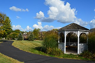
Franconia is a census-designated place (CDP) in Fairfax County, Virginia, United States. The population was 18,245 at the 2010 census, down from 31,907 in 2000 due to the splitting off of part of it to form the Kingstowne CDP.

Franconia–Springfield station is a Washington Metro rapid transit station and Virginia Railway Express commuter rail station located in Springfield, Virginia, United States. The station is the southwestern terminus of the Metro Blue Line and an intermediate station on the VRE Fredericksburg Line. It is also a major bus terminal for Fairfax Connector buses, plus other local and intercity bus routes. The station has one island-platform serving the two Metro tracks, plus two side platforms serving the RF&P Subdivision on which the Fredericksburg Line runs.

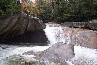
Franconia Notch State Park is a public recreation area and nature preserve that straddles eight miles (13 km) of Interstate 93 as it passes through Franconia Notch, a mountain pass between the Kinsman Range and Franconia Range in the White Mountains of northern New Hampshire, United States. The northern part of the park, including Cannon Mountain and Echo and Profile lakes, is in the town of Franconia, and the southern part, including Lonesome Lake and the Flume, is in Lincoln. Attractions in the state park include the Flume Gorge and visitor center, the Old Man of the Mountain historical site, fishing in Echo Lake and Profile Lake, and miles of hiking, biking and ski trails.
The Pemigewasset River, known locally as "The Pemi", is a river in the state of New Hampshire, the United States. It is 65.0 miles (104.6 km) in length and drains approximately 1,021 square miles (2,644 km2). The name "Pemigewasset" comes from the Abenaki word bemijijoasek [bəmidzidzoasək], meaning "where side (entering) current is".

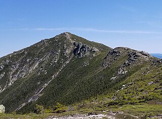
Mount Lafayette is a 5,249-foot (1,600 m) mountain at the northern end of the Franconia Range in the White Mountains of New Hampshire, United States. It lies in the town of Franconia in Grafton County, and appears on the New England Fifty Finest list of the most topographically prominent peaks in New England. The mountain's upper reaches are located in the alpine zone, an area where only dwarf vegetation exists due to the harsh climate.
Mount Lincoln is a 5,089-foot-high (1,551 m) mountain within the Franconia Range of the White Mountains of New Hampshire. Lincoln is located between Little Haystack and Mount Lafayette. All three overlook Franconia Notch. The west side of Lincoln drains into the main stem of the Pemigewasset River. The east side drains into Lincoln Brook, thence into the Franconia Branch of the Pemigewasset.

Mount Flume is a 4,328-foot (1,319 m) mountain at the southern end of the Franconia Range in the White Mountains of New Hampshire, United States. Mount Flume is the lowest in elevation of the peaks in the Franconia Range that are accessible by official hiking trails.

The Franconian Circle was an Imperial Circle established in 1500 in the centre of the Holy Roman Empire. It comprised the eastern part of the former Franconian stem duchy—roughly corresponding with the present-day Bavarian Regierungsbezirke of Upper, Middle and Lower Franconia—while western Rhenish Franconia belonged to the Upper Rhenish Circle. The title of a "Duke of Franconia" was claimed by the Würzburg bishops.

The Gale River is a 13.1-mile-long (21.1 km) tributary of the Ammonoosuc River in northwestern New Hampshire in the United States. Via the Ammonoosuc, it is part of the watershed of the Connecticut River, which flows to Long Island Sound.

The East Branch of the Pemigewasset River is a 15.8-mile-long (25.4 km) river located in the White Mountains of New Hampshire in the United States. It is a tributary of the Pemigewasset River, part of the Merrimack River watershed.

Little Haystack Mountain is a peak on the Franconia Range of the White Mountains located in Grafton County, New Hampshire, United States. It is flanked to the north by Mount Lincoln and to the southwest by Mount Liberty.

Kinsman Mountain is a mountain located in Grafton County, New Hampshire. It is named after Nathan Kinsman, an early resident of Easton, New Hampshire, and is part of the Kinsman Range of the White Mountains. To the northeast, Kinsman is connected by The Cannon Balls ridge to Cannon Mountain.
The Franconia Range is a mountain range located in the White Mountains of the U.S. state of New Hampshire. It is the second-highest range of peaks in the White Mountains.
Franconia is an unincorporated community in Franconia Township in Montgomery County, Pennsylvania, United States. Franconia is located at the intersection of Pennsylvania Route 113 and Allentown Road.
Franconia is an unincorporated community in Franconia Township, Chisago County, Minnesota, United States.
The Franconia Formation is a geologic formation in the upper mid-western United States, with outcroppings found in Illinois, Indiana, Iowa, Michigan, Minnesota, Missouri, Ohio, and Wisconsin. It preserves fossils dating back to the Cambrian period. It was named the Franconia Formation due to the first published documentation of exposures in vicinity of Franconia, Minnesota in the 1897 Ph.D. dissertation by Charles P. Berkley at the University of Minnesota titled Geology of the St. Croix Dalles. The Franconian stratigraphic stage was named after this formation.


