
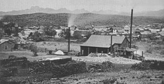
Swansea is a ghost town in La Paz County in the U.S. state of Arizona. It was settled circa 1909 in what was then the Arizona Territory. It served as a mining town as well as a location for processing and smelting the copper ore taken from the nearby mines.

Gleeson is a ghost town situated in southeastern Cochise County, Arizona, United States. It has an estimated elevation of 4,924 feet (1,501 m) above sea level. The town was first settled as Turquoise in the 1870s in what was then the Arizona Territory, then later re-established as Gleeson in 1900.

Ruby is a ghost town in Santa Cruz County, Arizona, United States. It was founded as a mining town in Bear Valley, originally named Montana Camp, so named because the miners were mining at the foot of Montana Peak.

Charleston is a ghost town in Cochise County in the southeastern part of the U.S. state of Arizona. It was occupied from the late-1870s through the late-1880s, and was located in what was then known as the Arizona Territory. Located on the west bank of the San Pedro River, Charleston's economy was based on milling silver ore mined from nearby Tombstone in the community of Millville, located directly across the river.

Contention City or Contention is a ghost mining town in Cochise County in the southeastern part of the U.S. state of Arizona. It was occupied from the early-1880s through the late-1880s in what was then known as the Arizona Territory. Only a few foundations now remain of this boomtown which was settled and abandoned with the rise and fall of silver mining in and around the area of Tombstone.

Tiger is a former populated place in Pinal County in the U.S. state of Arizona. The town was settled as Schultzcirca 1881 in what was then the Arizona Territory, then later reestablished as Tiger after World War I.
Pinal or Pinal City is a ghost town in Pinal County in the U.S. state of Arizona. The town was populated from the 1870s into the 1890s, in what was then the Arizona Territory.

Castle Dome Landing, Arizona is a ghost town in the Castle Dome Mountains of Yuma County in the U.S. state of Arizona. It was first settled as a transport depot and mining camp around 1863 in what was then the Arizona Territory.

Alamo Crossing is a ghost town in Mohave County, Arizona, United States. The town was settled in the late 1890s, in what was then the Arizona Territory. It served as a camp for mining prospectors in the manganese-rich Artillery Mountains, being the only town in the area. After 1918, the post office permanently closed, but the town was only intermittently abandoned, with its founders often present through until at least the mid-1950s. The town was intentionally flooded in 1968 to create Alamo Lake. In 2020, the area of Alamo was revived for mining again, this time for surface-level gold prospecting.

Alexandra is a ghost town in Yavapai County, Arizona, United States. The ghost town was settled during the frontier days of 1875 as a mining camp until abandoned in 1896. Alexandra is ten miles east of Mayer.
American Flag is a ghost town in Pinal County, Arizona, five miles southeast of Oracle. The town was established in the late 1870s, but shortly after 1890, the town had become abandoned.
Dome is a ghost town located in Yuma County, in southwestern Arizona, United States. It is located in the Dome Valley south of the Gila River. Originally Swiveler's Station, 20 miles (32 km) east of Fort Yuma on the Butterfield Overland Mail route, a post office was established here in 1858. It was first under the name of Gila City, the nearby boomtown one and a half miles (2.4 km) west of Swiveler's, but the post office closed July 14, 1863, after most of the town was swept away in the Great Flood of 1862, and then abandoned for the La Paz gold rush along the Colorado River. After the railroad passed by the site and an attempt at large scale mining of the placers began, a new post office was established as Dome in 1892 but soon closed when the attempt failed. Subsequently it opened and closed several times before finally closing in 1940.

The Mineral Park mine is a large open pit copper mine located in the Cerbat Mountains 14 miles northwest of Kingman, Arizona, in the southwestern United States. A 2013 report said that Mineral Park has an estimated reserves of 389 million tonnes of ore grading 0.14% copper and 31 million oz of silver.

Twin Buttes is a populated place on the east flank of the Sierrita Mountains approximately twenty miles south of Tucson, in Pima County, Arizona, United States. Named after a prominent hill located next to the town, Twin Buttes was founded as a small mining town circa 1903 and abandoned around 1930. Much of the actual town site is now buried underneath mine tailings, and all that remains is the Twin Buttes Cemetery.

San Xavier is a populated place in Pima County, Arizona, United States, situated seventeen miles southwest of Tucson, and six miles northwest of Sahuarita. Originally a small silver mining camp from the 1880s, today San Xavier is little more than a collection of rural homes and partially abandoned mines. The ghost towns of Azurite and Mineral Hill were located about one mile north of San Xavier. Twin Buttes was five miles southeast.

Silver Bell is a ghost town in the Silver Bell Mountains in Pima County, Arizona, United States. The name "Silver Bell" refers to a more recent ghost town, which was established in 1954 and abandoned in 1984. The original town, established in 1904, was named "Silverbell" and abandoned in the early 1930s. Both towns were utilized and later abandoned due to the mining of copper in the area.

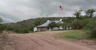
Salero is a ghost town in the Santa Rita Mountains of Santa Cruz County, Arizona. As one of the best preserved ghost towns remaining in Arizona, Salero is located on private property of the Salero Ranch and is not open to visitors.

Alto is a ghost town in Santa Cruz County, Arizona, first settled in the early 1900s in what was then part of the Tyndall Mining District, east of Tubac in the Santa Rita Mountains. The town was originally named El Plomo, which is Spanish for "lead", and was changed to Alto, meaning "high", many years later, probably because the mines were located high up on a steep mountainside.
Norton's Landing or Norton's, was a steamboat landing on the Colorado River, in what was then Yuma County, Arizona Territory. Today it is in La Paz County, Arizona. Nortons Landing is 52 miles upriver from Yuma, Arizona 4 miles above Picacho, California and 18 miles below the Clip, Arizona landing. It lies on a rocky point of land next to the river at 215 feet of elevation just east of Red Cloud Wash and Black Rock Wash, where roads to the district mines in the mountains met the Colorado River.


