Blow's Down

Last updated

Blow's Down
Site of Special Scientific Interest
Blow's Downs (May 2017).jpg
Northwest-facing view from the viewpoint at Blow's Downs SSSI.
Location Bedfordshire
Grid reference TL033214
InterestBiological
Area33.1 hectares
Notification 1989
Location map Magic Map

Blow's Down (or Blow's Downs) is a 33.1-hectare (82-acre) biological Site of Special Scientific Interest in Dunstable in Bedfordshire. It was notified in 1989 under Section 28 of the Wildlife and Countryside Act 1981, and the local planning authority is Central Bedfordshire Council. [1] [2] The site forms around half of the 62.3-hectare (154-acre) Blow's Downs nature reserve, which is managed by the Wildlife Trust for Bedfordshire, Cambridgeshire and Northamptonshire. [3] It has a maximum elevation of 212 m. [4]

Contents

The site has varied habitats with a large area of unimproved grassland, a scarce survival of this important habitat. Cattle help to maintain the pasture. Features include a disused quarry and medieval cultivation terraces. A rare plant, Bunium bulbocastanum, and beetle Odontaeus armiger [1] can be found at the site.

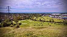
Dunstable is built around Blow's Down, from the south around clockwise to the east. The A5 road follows a valley between the Blow's Down and the neighbouring Dunstable Downs, which together make up part of the Chiltern Hills range.

There is access from Jeans Way in the north, from Jardine Way and Half Moon Lane in the west, and from Skimpot Road in the east. [2]

Northwest-facing view of Dunstable from the viewpoint of Blow's Downs at sunset (August 2016). Blow's Downs at Sunset.jpg
Northwest-facing view of Dunstable from the viewpoint of Blow's Downs at sunset (August 2016).

History

A sketch of the sites of the remains of neolithic huts found on Blow's Down, from Worthington G. Smith's Man, the Primeval Savage. Neolithic Huts on Blow's Down Sketch.jpg
A sketch of the sites of the remains of neolithic huts found on Blow's Down, from Worthington G. Smith's Man, the Primeval Savage.

Neolothic era

Blow's Down has a lengthy history, with evidence of human habitation dating back around 4000 years. [5] The archeologist Worthington G. Smith identified several remains of neolithic huts, finding among other things a horse's bone and, in 1888, part of a human skeleton. [6]

Medieval period

Following the establishment of the town of Dunstable by Henry I, the land would likely have been rented by the king, with the slopes of the downs being mainly used for grazing as they were too steep to plough. [5] There is however, some evidence of crops being grown, namely the existence of strip lynchets, quite visible in the area now known as Cottage Bottom fields. Blow's Down was one of relatively few places in England permitted to hold tournaments during times of calm, with a tournament being held in 1214. [7] The fields at the foot of Blow's Down would likely have made ideal locations for such mock battles of the time.

Thomas Jefferys' 1765 map of Bedfordshire, showing Dunstable as "Dunstaple" and the area now known as Blow's Down as "Souches Downs" Jefferys' 1765 map of Beds Dunstable.jpg
Thomas Jefferys' 1765 map of Bedfordshire, showing Dunstable as "Dunstaple" and the area now known as Blow's Down as "Souches Downs"

At the top of the downs lies Zouche's farm, which is likely to have been the site of Zouche's manor, an important estate of the family of the name la Zouche of Harringworth, who leased the land in the mid 14th century. For a while, among other names, Blow's down was eponymously referred to as Zouche's (or Souches) Downs, as seen in Jefferys' 1765 map of Bedfordshire.

1800s and onwards

Throughout the 1800s and later, the Downs underwent several changes from human activity. The parliamentary enclosures of the early 1800s would likely have drastically changed the appearance of Blow's Downs, due to hedges planted to separate fields. Around this time is when the Downs became known by the name they are known today, probably named after tenant farmers at Zouche's farm with the surname "Blow". [8] [5]

In the early 20th century, commercial chalk extraction brought further, large changes to Blow's Downs. There is evidence of a limeworks on the Downs by 1901. [5] [9] The Luton-Dunstable rail link, which opened in 1858, provided transportation of lime away from Blow's Down. The British Portland Cement Manufacturing Company acquired the lease to the site, and were still running the works during the 1920s. Production ceased some time before the Second World War, with the chalk pit being used by the Home Guard as a training area.

Related Research Articles

<span class="mw-page-title-main">Dunstable Downs</span> Part of Chiltern Hills, England

Dunstable Downs are part of the Chiltern Hills, in southern Bedfordshire in England, located near the town of Dunstable. They are a chalk escarpment forming the north-eastern reaches of the Chilterns. At 243 m (797 ft), Dunstable Downs are the highest point in the county of Bedfordshire.

<span class="mw-page-title-main">Toddington, Bedfordshire</span> Human settlement in England

Toddington is a large village and civil parish in the county of Bedfordshire, England. It is situated 5 miles north-north-west of Luton, 4 miles (6 km) north of Dunstable, 6 miles (10 km) south-west of Woburn, and 35 miles north-north-west of London on the B5120 and B579. It is 0.5 miles from Junction 12 of the M1 motorway and lends its name to the nearby motorway service station. The hamlet of Fancott also forms part of the Toddington civil parish.

<span class="mw-page-title-main">Wildlife Trust for Bedfordshire, Cambridgeshire and Northamptonshire</span> Charity in Bedfordshire, Cambridgeshire and Northamptonshire

The Wildlife Trust for Bedfordshire, Cambridgeshire and Northamptonshire (WTBCN) is a registered charity which manages 126 nature reserves covering 3,945 hectares. It has over 35,000 members, and 95% of people in Bedfordshire, Cambridgeshire and Northamptonshire live within five miles of a reserve. In the year to 31 March 2016 it employed 105 people and had an income of £5.1 million. It aims to conserve wildlife, inspire people to take action for wildlife, offer advice and share knowledge. The WTBCN is one of 36 wildlife trusts covering England, and 46 covering the whole of the United Kingdom.

<span class="mw-page-title-main">Cooper's Hill, Bedfordshire</span>

Cooper's Hill is an 18.1-hectare (45-acre) biological Site of Special Scientific Interest in Ampthill in Bedfordshire. It was notified under Section 28 of the Wildlife and Countryside Act 1981 in 1984, and the planning authority is Central Bedfordshire Council. A smaller area of 12.7 hectares is also a Local Nature Reserve, Part of the site is managed by the Wildlife Trust for Bedfordshire, Cambridgeshire and Northamptonshire.

<span class="mw-page-title-main">Dropshort Marsh</span>

Dropshort Marsh is a 2.7-hectare (6.7-acre) biological Site of Special Scientific Interest in Toddington in Bedfordshire. It was notified under Section 28 of the Wildlife and Countryside Act 1981 in 1985, and the local planning authority is Central Bedfordshire Council. The site is managed by the Wildlife Trust for Bedfordshire, Cambridgeshire and Northamptonshire.

<span class="mw-page-title-main">Lancot Meadow</span>

Lancot Meadow is a 2-hectare (4.9-acre) nature reserve in western Dunstable in Bedfordshire. It is managed by the Wildlife Trust for Bedfordshire, Cambridgeshire and Northamptonshire.

<span class="mw-page-title-main">Pegsdon Hills and Hoo Bit</span>

Pegsdon Hills and Hoo Bit is a 79-hectare (200-acre) nature reserve in Pegsdon in Bedfordshire. It is managed by the Wildlife Trust for Bedfordshire, Cambridgeshire and Northamptonshire. The site is on the border between Bedfordshire and Hertfordshire, and it covers Pegsdon Hills and part of the adjacent Deacon Hill in Bedfordshire, and Hoo Bit in Hertfordshire. It is in the Chilterns Area of Outstanding Natural Beauty, and part of the site is designated by Natural England as the Deacon Hill SSSI.

<span class="mw-page-title-main">Sewell Cutting</span>

Sewell Cutting is a 3.6-hectare (8.9-acre) nature reserve at Sewell in Houghton Regis in Bedfordshire. It is owned by Central Bedfordshire Council and managed by the Wildlife Trust for Bedfordshire, Cambridgeshire and Northamptonshire.

<span class="mw-page-title-main">Totternhoe Knolls</span>

Totternhoe Knolls is a 13.1-hectare (32-acre) Site of Special Scientific Interest (SSSI) in Totternhoe in Bedfordshire. It is also a local nature reserve, and part of the Chilterns Area of Outstanding Natural Beauty. The site is owned by Central Bedfordshire Council and leased to the National Trust. Most of the site is maintained jointly by the National Trust and the Wildlife Trust for Bedfordshire, Cambridgeshire and Northamptonshire (WTBCN), and is part of the WTBCN Totternhoe nature reserve, which also includes Totternhoe Chalk Quarry and Totternhoe Stone Pit. The SSSI also includes Totternhoe Castle, the earthworks of a Norman motte-and-bailey castle which is a Scheduled monument.

<span class="mw-page-title-main">Totternhoe Chalk Quarry</span>

Totternhoe Chalk Quarry is a 13.4-hectare (33-acre) biological Site of Special Scientific Interest in Totternhoe in Bedfordshire. Part of it lies in Totternhoe nature reserve, which is managed by the Wildlife Trust for Bedfordshire, Cambridgeshire and Northamptonshire. The site is part of the Chilterns Area of Outstanding Natural Beauty.

<span class="mw-page-title-main">Cherry Hinton Pit</span>

Cherry Hinton Pit is a 12.8-hectare (32-acre) biological Site of Special Scientific Interest (SSSI) on the south-eastern outskirts of Cambridge. The site consists of East Pit and most of the smaller West Pit. East Pit is part of the Limekiln Close and East Pit Local Nature Reserve, which is managed by the Wildlife Trust for Bedfordshire, Cambridgeshire and Northamptonshire under the name Cherry Hinton Chalk Pits. West Pit is a separate Local Nature Reserve (LNR).

<span class="mw-page-title-main">Chettisham Meadow</span>

Chettisham Meadow is a 0.7-hectare (1.7-acre) biological Site of Special Scientific Interest west of Chettisham, 3 km (2 mi) north of Ely in Cambridgeshire. It is managed by the Wildlife Trust for Bedfordshire, Cambridgeshire and Northamptonshire.

<span class="mw-page-title-main">Fulbourn Fen</span>

Fulbourn Fen is a 27.3-hectare (67-acre) biological Site of Special Scientific Interest east of Fulbourn, Cambridgeshire. It is privately owned and managed by the Wildlife Trust for Bedfordshire, Cambridgeshire and Northamptonshire.

<span class="mw-page-title-main">Dunstable and Whipsnade Downs</span>

Dunstable and Whipsnade Downs is a 73.4-hectare (181-acre) Site of Special Scientific Interest in Dunstable in Bedfordshire. It was notified in 1987 under Section 28 of the Wildlife and Countryside Act 1981, and the local planning authority is Central Bedfordshire Council. It is in the Chilterns Area of Outstanding Natural Beauty, and part of it is owned by the National Trust.

<span class="mw-page-title-main">Kings and Bakers Woods and Heaths</span>

Kings and Bakers Woods and Heaths is a 212.8-hectare (526-acre) Site of Special Scientific Interest (SSSI) between Heath and Reach in Bedfordshire and Great Brickhill in Buckinghamshire. The site is mainly in Bedfordshire but includes Rammamere Heath in Buckinghamshire. It was notified in 1984 under Section 28 of the Wildlife and Countryside Act 1981, and the local planning authorities are Central Bedfordshire Council and Aylesbury Vale Council. Part of it is a National Nature Reserve, and part of it is a nature reserve managed by the Wildlife Trust for Bedfordshire, Cambridgeshire and Northamptonshire. it is also a Nature Conservation Review site.

<span class="mw-page-title-main">Deacon Hill SSSI</span> Protected area in Bedfordshire, England

Deacon Hill SSSI is a 35.4-hectare (87-acre) biological Site of Special Scientific Interest in Pegsdon in Bedfordshire. It is in the Chilterns Area of Outstanding Natural Beauty, and it is part of the Pegsdon Hills and Hoo Bit nature reserve, managed by Wildlife Trust for Bedfordshire, Cambridgeshire and Northamptonshire.

<span class="mw-page-title-main">Fancott Woods and Meadows</span> Site of Special Scientific Interest in Bedfordshire, England

<span class="mw-page-title-main">Houghton Regis Marl Lakes</span>

Houghton Regis Marl Lakes is a 20.1-hectare (50-acre) biological Site of Special Scientific Interest in Houghton Regis in Bedfordshire. It was notified under the Wildlife and Countryside Act 1981 in 1988.

<span class="mw-page-title-main">Totternhoe nature reserve</span>

Totternhoe nature reserve is managed by the Wildlife Trust for Bedfordshire, Cambridgeshire and Northamptonshire (WTBCN). The 31-hectare (77-acre) site is in Totternhoe in Bedfordshire, and it includes parts of three Sites of Special Scientific Interest (SSSIs). Totternhoe Knolls is a biological SSSI owned by Central Bedfordshire Council and leased to the National Trust. Most of it is managed jointly by the National Trust and the WTBCN, excluding Totternhoe Castle, the earthworks of a Norman motte-and-bailey castle which is part of the SSSI but not of WTBCN's nature reserve. Totternhoe nature reserve also includes the geological SSSI, Totternhoe Stone Pit, which is not open to the public, and other areas owned by WTBCN, including part of Totternhoe Chalk Quarry, another biological SSSI.

References

  1. 1 2 "Blow's Down citation" (PDF). Sites of Special Scientific Interest. Natural England. Archived from the original (PDF) on 4 March 2016. Retrieved 24 August 2015.
  2. 1 2 "Map of Blow's Down". Sites of Special Scientific Interest. Natural England. Retrieved 24 August 2015.
  3. "Blow's Downs". Wildlife Trust for Bedfordshire, Cambridgeshire and Northamptonshire. Retrieved 24 August 2015.
  4. Ltd, Copyright The mountain Guide-A.-Connect. "Blow's Down | England". UK mountain Guide. Retrieved 3 August 2023.
  5. 1 2 3 4 Turner, David (February 2015). "Blow's Downs" (PDF). Dunstable District Local History History Newsletter No. 43. pp. 320–321.
  6. Smith, Worthington George (1894). Man, The Primeval Savage. pp. 323–325.
  7. Osborne, Mike (2021). Defending Bedfordshire. Fonthill Media.
  8. Turner, David (2016). "Blow's Downs Update" (PDF). Dunstable & District Local History Society Newsletter No. 46. p. 335.
  9. "Bedfordshire Sheet XXXII.NE". National Library of Scotland. Retrieved 4 August 2023.

51°52′59″N0°30′07″W / 51.883°N 0.502°W / 51.883; -0.502