Broomall, Pennsylvania | |
---|---|
Coordinates: 39°58′18″N75°21′17″W / 39.97167°N 75.35472°W | |
Country | United States |
State | Pennsylvania |
County | Delaware |
Township | Marple |
Area | |
• Total | 3.17 sq mi (8.21 km2) |
• Land | 3.17 sq mi (8.21 km2) |
• Water | 0.00 sq mi (0.00 km2) |
Elevation | 351 ft (107 m) |
Population | |
• Total | 11,718 |
• Density | 3,698.86/sq mi (1,428.08/km2) |
Time zone | UTC-5 (EST) |
• Summer (DST) | UTC-4 (EDT) |
ZIP code | 19008 |
Area codes | 610 and 484 |
FIPS code | 42-09248 |
Broomall is a census-designated place (CDP) in Marple Township, Delaware County, Pennsylvania, United States. The population was 10,789 at the 2010 census. [3]
This crossroads community was renamed for the post office established to honor John Martin Broomall, [4] a 19th-century U.S. congressman, Electoral College member (at Ulysses S. Grant's 1872 presidential election), and Chester Gas Company president from Upper Chichester Township in Delaware County, Pennsylvania. [5]
Broomall is home to the biotechnology company Drummond Scientific Company. Drummond's Pipet-Aid pipette controller, released in 1972, improved accuracy and pipetting capabilities in laboratories. [6]
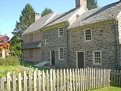
The Thomas Massey House is listed on the National Register of Historic Places. [7]
Broomall is located in northeastern Delaware County at 39°58′18″N75°21′17″W / 39.97167°N 75.35472°W (39.971561, −75.354674). [8] It is in the eastern part of Marple Township and is bordered to the east by Darby Creek and to the north by Pennsylvania Route 3 (West Chester Pike). Pennsylvania Route 320 (Sproul Road) is the main north–south road in the community. Broomall is 10 miles (16 km) west of Center City Philadelphia.
According to the United States Census Bureau, the CDP has a total area of 2.9 square miles (7.5 km2), all land. [3] The climate is a hot-summer humid continental climate (Dfa) very closely bordering a humid subtropical climate (Cfa). PRISM Climate Group, Oregon State U Average monthly temperatures range from 31.9 °F in January to 77.1 °F in July. PRISM Climate Group, Oregon State U The local hardiness zone is 7a.
Public schools located in Broomall that are part of the Marple Newtown School District are:
Marple Newtown Senior High School is the public school for Newtown Square, Newtown Township, and Broomall, Marple Township. Paxon Hollow Middle School Participates in an annual fundraiser for Alex's Lemonade Stand with Haverford Middle School.
As of the census [9] of 2000, there were 11,046 people, 4 households, and 3,148 families residing in the CDP. The population density was 3,807.1 inhabitants per square mile (1,469.9/km2). There were 4,339 housing units at an average density of 1,495.5 per square mile (577.4/km2). The racial makeup of the CDP was 91.41% White, 0.63% African American, 0.10% Native American, 7.17% Asian, 0.16% from other races and 0.53% from two or more races. Hispanic or Latino of any race were 0.62% of the population.
There were 4 households, out of which 28.4% had children under the age of 18 living with them, 62.2% were married couples living together, 8.6% had a female householder with no husband present, and 26.1% were non-families. 22.8% of all households were made up of individuals, and 12.8% had someone living alone who was 65 years of age or older. The average household size was 2.57 and the average family size was 3.06 people.
In the CDP the population was spread out, with 21.4% under the age of 18, 6.5% from 18 to 24, 26.2% from 25 to 44, 24.6% from 45 to 64, and 21.2% who were 65 years of age or older. The median age was 43 years. For every 100 females, there were 92.1 males. For every 100 females age 18 and over, there were 88.8 males.
The median income for a household in the CDP was $52,354, and the median income for a family was $63,902. Males had a median income of $45,181 versus $31,646 for females. The per capita income for the CDP was $24,940. About 2.4% of families and 4.4% of the population were below the poverty line, including 3.7% of those under the age of 18.
Census | Pop. | Note | %± |
---|---|---|---|
2000 | 11,046 | — | |
2010 | 10,789 | −2.3% | |
2020 | 11,718 | 8.6% | |
Sources: [10] [9] [11] [12] [2] |
Delaware County, colloquially referred to as Delco, is a county in the Commonwealth of Pennsylvania. With a population of 576,830 as of the 2020 census, it is the fifth-most populous county in Pennsylvania and the third-smallest in area. The county was created on September 26, 1789, from part of Chester County and named for the Delaware River.
Croydon is a census-designated place located in Bristol Township, Bucks County, Pennsylvania, United States. As of the 2010 census, the CDP had a total population of 9,950.
Northampton Township is a township in Bucks County, Pennsylvania, United States. The township is located approximately 12 miles northeast of Philadelphia. The population was 39,915 at the 2020 census.
Easttown Township is a township in Chester County, Pennsylvania, United States. The population was 10,984 at the 2020 census. The township, which lies in the western half of Philadelphia's Main Line suburbs, is comprised predominantly of parts of two unincorporated areas: Devon and Berwyn. A small portion of the township has a Paoli address.
Boothwyn is a census-designated place (CDP) in Delaware County, Pennsylvania, United States. The population was 4,933 at the 2010 census, down from 5,206 at the 2000 census. The census estimation for population circa 2019 is 6,115.
Folsom is a census-designated place (CDP) in Delaware County, Pennsylvania, United States. It is part of Ridley Township. The population was 8,323 at the 2010 census.
Lima is an unincorporated community and census-designated place (CDP) in Middletown Township, Delaware County, Pennsylvania, United States. The population was 2,735 at the 2010 census, down from 3,225 at the 2000 census.
Marple Township is a township in Delaware County, Pennsylvania, United States. It contains the census designated place of Broomall. The population was estimated at 23,743 as of 2015. ZIP codes include mainly 19008, as well as 19064 and 19063. The township is run by Marple Township board of commissioners.
Newtown Township, also referred to by the name of its post office of Newtown Square, is a township in Delaware County, Pennsylvania, United States. Prior to 1789, it was part of Chester County. As of the 2020 census, the population was 15,002.
Upper Chichester Township is a civil township in Delaware County, Pennsylvania, United States. The population was 16,738 at the 2010 census.
Village Green-Green Ridge is a census-designated place (CDP) in Delaware County, Pennsylvania, United States. The population was 7,822 at the 2010 census, down from 8,279 at the 2000 census.
Woodlyn is a census-designated place (CDP) in Delaware County, Pennsylvania, United States. The population was 9,485 at the 2010 census, down from 10,036 at the 2000 census. It is a part of Ridley Township, and children residing within the community generally attend schools in the Ridley School District. Woodlyn is served by the Woodlyn Fire Co. for fire, rescue and EMS services.
Mexico is an unincorporated community and census-designated place (CDP) in Walker Township, Juniata County, Pennsylvania, United States.
Mountain Top is an unincorporated area and census-designated place (CDP) in Luzerne County, Pennsylvania, United States. As of the 2010 census, its population was 10,982.
Eagleville is a census-designated place (CDP) in Montgomery County, Pennsylvania, United States. The population was 4,800 at the 2010 census. It is within Lower Providence Township.
Wyncote is a census-designated place (CDP) in Cheltenham Township, Montgomery County, Pennsylvania, United States. It borders the northwestern and northeastern section of Philadelphia. Wyncote is located 11 miles from Center City Philadelphia at the southeasternmost tip of Montgomery County. The Jenkintown-Wyncote SEPTA station is the fifth busiest regional rail station in the SEPTA system.
Newtown is a census-designated place (CDP) in Reilly Township, Schuylkill County in the U.S. state of Pennsylvania. The population was 244 at the 2000 census.
Harrison City is a census-designated place (CDP) in Westmoreland County, Pennsylvania, United States. The population was 174 at the 2020 census.
Berwyn is a census-designated place (CDP) in Chester County, Pennsylvania, United States. Berwyn is located within Tredyffrin and Easttown Townships. The area is part of the Philadelphia Main Line suburbs.
Villanova is a suburb of Philadelphia, Pennsylvania, United States. It straddles Lower Merion Township in Montgomery County and Radnor Township in Delaware County. It is located at the center of the Philadelphia Main Line, a series of Philadelphia suburbs located along the original east–west railroad tracks of the Pennsylvania Railroad. It is served by the SEPTA Paoli/Thorndale Line regional rail train and the Norristown High Speed Line.