
Ashley County is a rural South Arkansas county with a culture, economy, and history based on timber and agriculture. Created as Arkansas's 52nd county on November 30, 1848, Ashley County has seven incorporated municipalities, including Hamburg, the county seat and Crossett, the most populous city. The county is also the site of numerous unincorporated communities and ghost towns. The county is named for Chester Ashley, a prominent lawyer in the Arkansas Territory and U.S. senator from the state from 1844 to 1848.
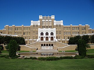
Little Rock Central High School (LRCHS) is an accredited comprehensive public high school in Little Rock, Arkansas, United States. The school was the site of forced desegregation in 1957 after the U.S. Supreme Court ruled that segregation of public schools was unconstitutional three years earlier. This was during the period of heightened activism in the civil rights movement.

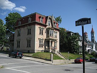
Hillcrest Historic District is a historic neighborhood in Little Rock, Arkansas that was listed on the National Register of Historic Places on December 18, 1990. It is often referred to as Hillcrest by the people who live there, although the district's boundaries actually encompass several neighborhood additions that were once part of the incorporated town of Pulaski Heights. The town of Pulaski Heights was annexed to the city of Little Rock in 1916. The Hillcrest Residents Association uses the tagline "Heart of Little Rock" because the area is located almost directly in the center of the city and was the first street car suburb in Little Rock and among the first of neighborhoods in Arkansas.

Jenkins' Ferry Battleground State Park is the site of the American Civil War battle of Jenkins' Ferry, also known as the Engagement at Jenkins' Ferry, fought on Saturday, April 30, 1864, in present-day Grant County, Arkansas. The park was listed in the U.S. National Register of Historic Places on January 21, 1970, and, with seven other sites, is part of the Camden Expedition Sites National Historic Landmark, designated a National Historic Landmark District on April 19, 1994.

Capitol View/Stifft's Station is a neighborhood of Little Rock, Arkansas, in the west-central portion of the city encompassing approximately 1500 homes. Roughly, its boundaries include the area south of West Markham, north of Interstate 630, east of Pine, and west of Summit, as well as south of Riverview between Park and Summit. Capitol View/Stifft's Station is just west of Downtown, north of the Central High School Historic District, southeast of Pulaski Heights and uses the 72205 ZIP code.
The Highlands Historic District is a historic district roughly bounded by June, Cherry, and Weetamoe Streets, Lincoln, Highland, President, North Main, and Hood Avenues in Fall River, Massachusetts. The district lies just north of the Lower Highlands Historic District.

U.S. Route 64 is a U.S. highway running from Teec Nos Pos, Arizona east to Nags Head, North Carolina. In the U.S. state of Arkansas, the route runs 246.35 miles (396.46 km) from the Oklahoma border in Fort Smith east to the Tennessee border in Memphis. The route passes through several cities and towns, including Fort Smith, Clarksville, Russellville, Conway, Searcy, and West Memphis. US 64 runs parallel to Interstate 40 until Conway, when I-40 takes a more southerly route.
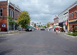
The Rogers Commercial Historic District is a historic district in the central business district of Rogers, Arkansas. When it was first listed on the National Register of Historic Places in 1988, it was known as the Walnut Street Historic District; this was changed when the district was enlarged in 1993. The district encompasses a portion of the city's central business district, whose historical significance extends from about 1885 to the end of the Second World War.
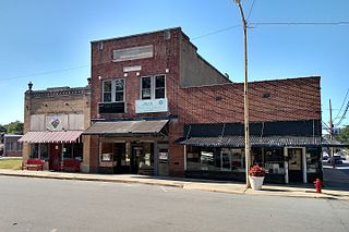
The Hale Avenue Historic District encompasses a significant portion of the central business district of Osceola, Arkansas. It extends for five blocks along Hale Avenue, between Ash and Maple Streets, and includes a few buildings on adjacent streets. The focal point of the district is the Mississippi County Courthouse, and the block of buildings opposite it on Hale Avenue. Although Osceola was founded in 1875, it was relocated beginning in 1900 to be closer to the railroad, with Hale Avenue as the major east–west route. This began a period of growth in the city which continued through much of the 1920s. Most of buildings on these blocks of Hale Avenue result from this time, and a number of those built later were built in an architecturally sympathetic manner.

The Governor's Mansion Historic District is a historic district covering a large historic neighborhood of Little Rock, Arkansas. It was listed on the National Register of Historic Places in 1978 and its borders were increased in 1988 and again in 2002. The district is notable for the large number of well-preserved late 19th and early 20th-century houses, and includes a major cross-section of residential architecture designed by the noted Little Rock architect Charles L. Thompson. It is the oldest city neighborhood to retain its residential character.

The Argenta Historic District encompasses significant historic elements of central North Little Rock, Arkansas. The area that is now central North Little Rock was known as Argenta when it was first settled, and remained unincorporated until it was annexed to Little Rock in 1890. William Faucette, a leading Argenta politician and businessman, orchestrated the incorporation of North Little Rock just beyond the annexed area in 1901, and then made a successful petition to separate Argenta from Little Rock into the new municipality in 1903. Subsequent attempts to rename North Little Rock to Argenta have failed.

The Calico Rock Methodist Episcopal Church is a historic former church building at 101 W. 1st in Calico Rock, Arkansas, just north of the Calico Rock Historic District. It is a single story brick structure, built in 1923–24 with Colonial Revival and Craftsman features. It has a front-gable roof with large Craftsman brackets and exposed rafters, with hip-roofed chancel and transept ends. The main entrance is sheltered by a gable-roofed porch supported by brick posts. The building served as home to a local Methodist congregation until c. 2007.

U.S. Highway 71 is a U.S. highway that runs from Krotz Springs, LA to the Fort Frances–International Falls International Bridge at the Canadian border. In Arkansas, the highway runs from the Louisiana state line near Doddridge to the Missouri state line near Bella Vista. In Texarkana, the highway runs along State Line Avenue with US 59 and partially runs in Texas. Other areas served by the highway include Fort Smith and Northwest Arkansas.

The Blytheville Commercial Historic District encompasses most of the central business district of Blytheville, Arkansas, one of the two county seats of Mississippi County. It extends along Main Street between 5th and Franklin Streets, and along Ash Street between 5th and 2nd. Most of the 39 buildings in the district were built between 1890 and 1956, in three phases of development. The two oldest buildings in the district, both dating to c. 1890, are at 112 West Main and 106 East Main. The building traditionally viewed as the anchor of the downtown area is the Kirby-Heath building at the corner of Main and 2nd, built 1901.

The Calico Rock Home Economics Building is a historic school building on 2nd Street in Calico Rock, Arkansas. It is a single-story stone structure with a gable roof and a concrete foundation. It was built in 1940 by crews funded by the National Youth Administration (NYA), who ranged in age from 15 to 18 and were paid 9 cents per hour. They hand-quarried stone at a site about 0.25 miles (0.40 km) away, and erected the building under the supervision of a local builder. The building includes four kitchen areas, a central work area, and restrooms. It is virtually unaltered from its original construction except for the replacement of windows.
The Lonoke Downtown Historic District encompasses a portion of the central business district of Lonoke, Arkansas. It extends south along Center Street, from the Lonoke County Courthouse to Front Street, and then one block east and west on both sides of Front Street. It extends eastward on the south side of Front Street another 1-1/2 blocks. Lonoke was founded as a railroad community in 1862, and this area represents the core of its downtown area for the period 1900–1945. Most of the district's 23 buildings are commercial structures, one to two stories in height, with brick facades.

The South Main Street Residential Historic District encompasses a residential area south of downtown Little Rock, Arkansas. The area, extending along South Main Street roughly between 19th and 23rd Streets, was developed between about 1880 and 1945, and includes a well-preserved set of residential architecture from that period. Notable buildings include the Luxor Apartments, the Holcomb Court Apartments, and the Ada Thompson Memorial Home.

The Dardanelle Commercial Historic District encompasses the part of the historic central business district of Dardanelle, Arkansas. The district extends along Front Street, from Pine Street in the north to nearly Oak Street in the south, and includes some properties on adjacent cross streets. Although this area has been commercially active since the 1820s, its present architecture reflects the late 19th and early 20th centuries, with modestly scaled one and two story masonry building predominating.
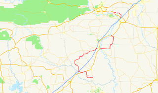
Highway 51 is a designation for two north–south state highways in Southwest Arkansas. One route of 53.37 miles (85.89 km) begins Highway 53 near Whelen Springs and runs north to US Highway 67 in Donaldson. A second route of 7.92 miles (12.75 km) runs parallel to US 270 northwest of Malvern. Both routes are maintained by the Arkansas Department of Transportation (ArDOT).


