Camerton, Cumbria

Last updated

Camerton
Camerton Hall at Camerton.jpg
Camerton Hall
Location map United Kingdom Allerdale.svg
Red pog.svg
Camerton
Location in Allerdale, Cumbria
Cumbria UK location map.svg
Red pog.svg
Camerton
Location within Cumbria
Population174 (2011)
OS grid reference NY037312
Civil parish
  • Camerton
Unitary authority
Ceremonial county
Region
Country England
Sovereign state United Kingdom
Post town WORKINGTON
Postcode district CA14
Dialling code 01900
Police Cumbria
Fire Cumbria
Ambulance North West
UK Parliament
List of places
UK
England
Cumbria
54°39′50″N3°29′42″W / 54.664°N 3.495°W / 54.664; -3.495 Coordinates: 54°39′50″N3°29′42″W / 54.664°N 3.495°W / 54.664; -3.495

Camerton is a small village and civil parish in Cumbria, historically part of Cumberland, near the Lake District National Park in England. According to older maps, it was originally called "Camberton".

Contents

The village is situated about 1 mile (1.6 km) north-east of Seaton, 3.9 miles (6.3 km) north-east of Workington and 7.8 miles (12.6 km) west of Cockermouth. It's linked by road to Great Broughton and Flimby, and there was a small footbridge over the river to Great Clifton however this was destroyed by the floods of November 2009. It has a population of 172, [1] increasing slightly to 174 at the 2011 Census. [2]

Governance

Camerton is part of the parliamentary constituency of Workington. In the 2019 United Kingdom general election, the Tory candidate for Workington, Mark Jenkinson, was elected MP, overturning a 9.4 per cent Labour majority from the 2017 election to eject Shadow Environment Secretary Sue Hayman by a margin of 4,136 votes. [3] Until the December 2019 general election, the Labour Party had won the seat in every general election since 1979.The Conservative Party had only been elected once in Workington since World War II, at the 1976 by-election. [4] Historically the village has been a Labour-supporting area.

For Local Government purposes it is in the Cumberland unitary authority area.

Camerton has its own Parish Council; Camerton Parish Council. [5]

Railways

Two railway lines once served Camerton. The line and railway station in the valley bottom were built by the Cockermouth and Workington Railway (CWR) which was eventually extended eastwards to Penrith, giving national connections and even the "Lakes Express", a through train to London, though this passed straight through Camerton. The station closed in 1952 and the line in 1966. In 2013 the station master's house was still in use as a private residence. The former railway embankment could still be seen, but the supports and pier of the former bridge over the river were washed away during the 2009 Workington floods, leaving no trace.

A second line ran on higher ground to the north of the village, this was the Cleator and Workington Junction Railway's (C&WJR) "Northern Extension" which was part of a wider venture to connect west Cumbrian ironworks with Scotland. Camerton never had a public station on that line, the nearest being at Seaton (Cumbria) and Great Broughton, though their lives as passenger stations were very short. Although this line lost its meagre passenger services past Camerton as early as 1908 and was closed and lifted north of Buckhill Colliery in the 1930s, trains still passed Camerton along it until 1992 to serve the RNAD Broughton Moor.

Collieries

Camerton once had two pits, both of which mined both coal and clay. Camerton No. 2 Colliery was north of the village next to the C&WJR line where an unadvertised workmen's halt was provided. This colliery appears to have been abandoned in 1908.

Camerton No. 1 Colliery was next to the river. It was connected to the CWR line. It is unclear when it was abandoned. [6]

Both pits had associated brickworks.

Etymology

'Tūn' is Old English for 'homestead' 'village'. The first element in the name might be a personal name (possibly 'Cāfmǣr') or else Welsh 'cym(m)er' 'confluence' that might refer to nearby stream and river, "but the phonology would offer difficulties, and the stream running into the Derwent is insignificant." [7] So, the name means perhaps 'the village of Cāfmǣr', or 'the village by the confluence of waters'.

St Peter's church

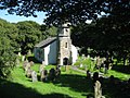
St Peter's church is located south-east of the village on a meander of the River Derwent. The church building partly dates from the mid-19th century, but "parts of the structure could be medieval, for instance, the transept arch with its step and chamfer." [8] The church contains the tomb of 'Black Tom', an old 'lord' of Camerton. According to local legend, Black Tom's ghost haunts the churchyard. Black Tom is also the name of the village pub. Legend has it that a blue pig was seen one night by someone leaving the pub.

Walking

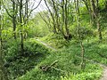
There are walking opportunities in the area including the nearby Scaw Bank wood.

See also

Related Research Articles

<span class="mw-page-title-main">Workington</span> Coastal town in Cumbria, England

Workington is a coastal town and civil parish at the mouth of the River Derwent on the west coast in Cumberland, Cumbria, England. At the 2011 census it had a population of 25,207.

<span class="mw-page-title-main">Cockermouth</span> Town and parish in England

Cockermouth is a market town and civil parish in Cumbria, England, so named because it is at the confluence of the River Cocker as it flows into the River Derwent. The mid-2010 census estimates state that Cockermouth has a population of 8,204, increasing to 8,761 at the 2011 Census.

<span class="mw-page-title-main">Allerdale</span> Former non-metropolitan district in England

Allerdale was a non-metropolitan district of Cumbria, England, with borough status. Its council was based in Workington and the borough has a population of 93,492 according to the 2001 census, increasing to 96,422 at the 2011 Census.

<span class="mw-page-title-main">Seaton, Cumbria</span> Human settlement in England

Seaton is a large village and civil parish in Cumbria, England. Historically part of Cumberland, near the Lake District National Park in England. It is home to around 5,000 people and is one of the largest villages in England. The population of the parish was measured in the 2011 Census as 5,022. Historically a part of Cumberland, it is situated on the north side of the River Derwent, across from the town of Workington, and close to the smaller village of Camerton. Seaton forms part of the Borough of Allerdale.

<span class="mw-page-title-main">Broughton Moor</span> Village in Cumbria, England

Broughton Moor is a village and civil parish in Cumbria, England. It is situated on an extensive moor about 2 miles (3.2 km) north of Broughton, 5 miles (8.0 km) north west of Cockermouth, 2.5 miles (4.0 km) south of Maryport and 4.5 miles (7.2 km) north of Workington.

<span class="mw-page-title-main">Bridekirk</span> Human settlement in England

Bridekirk is a village and civil parish in the Cumberland district in the county of Cumbria, England. It is around 3.2 kilometres (2 mi) north of the Derwent river and about the same distance from the nearest large town of Cockermouth just south of the river. Bridekirk is just outside the Lake District National Park and is not far from the Maryport and Carlisle Railway.

<span class="mw-page-title-main">Camerton railway station (Cumberland)</span> Disused railway station in Cumbria, England

Camerton railway station was situated next to the River Derwent on the Cockermouth and Workington Railway. It served the village of Camerton, Cumberland, England.

<span class="mw-page-title-main">Dearham</span> Village in Cumbria, England

Dearham is a village and civil parish in Cumbria, historically part of Cumberland, near the Lake District National Park in England. It lies about 2 miles (3.2 km) east of Maryport and 5 miles (8.0 km) west of Cockermouth.

<span class="mw-page-title-main">Workington Central railway station</span> Disused railway station in Cumbria, England

Workington Central railway station was opened by the Cleator and Workington Junction Railway (C&WJR) in 1879 to serve the town of Workington in Cumberland, England. It was situated almost half a mile nearer the town centre than its rival Workington station.

The Cockermouth & Workington Railway was an English railway company which built and operated a railway between the Cumberland towns of Workington and Cockermouth. The railway opened for service in 1847, and ran from the Whitehaven Junction Railway station at Workington to a station at Cockermouth near the bridge over the Derwent. A single-tracked line of eight and a half miles length, its revenue came largely from the transport of coal from the pits of the lower Derwent valley to the port at Workington for shipment by sea. The Marron extension of the Whitehaven, Cleator and Egremont Railway and the Derwent Branch of the Maryport and Carlisle Railway were both constructed to link with the C&WR and together give an alternative route for the northward movement of haematite ore from the Cumberland ore-field. The completion of the Cockermouth, Keswick and Penrith Railway made the C&WR part of a continuous through route between South Durham and the Cumberland orefield. These developments both improved the potential profitability of the C&WR, and made control of it important to bigger companies wishing to maximise the iron-ore traffic over their lines: the C&WR was absorbed by the London and North Western Railway in 1866.

<span class="mw-page-title-main">Great Broughton, Cumbria</span> Village in Cumbria, England

Great Broughton is a village and former civil parish, now in the parish of Broughton. It caters strongly for visitors. The estimated resident population was 1,823 in 2017. In 1891 the parish had a population of 1447.

<span class="mw-page-title-main">Great Broughton railway station</span> Disused railway station in Cumbria, England

Great Broughton railway station briefly served the village of Great Broughton, near Cockermouth in Cumberland, England.

<span class="mw-page-title-main">Seaton railway station (Cumbria)</span> Disused railway station in Cumbria, England

Seaton railway station served the village of Seaton, near Workington in Cumberland, England.

<span class="mw-page-title-main">Harrington (Church Road Halt) railway station</span> Disused railway station in Cumbria, England

Harrington railway station, or Church Road halt, was a railway station in Harrington, Cumbria, England. It was opened by the Cleator and Workington Junction Railway (C&WJR) on the company's Harrington Branch which connected with the Lowca Light Railway at Rosehill to provide a through route from Lowca to Workington Central and beyond.

<span class="mw-page-title-main">Rosehill (Archer Street Halt) railway station</span> Disused railway station in Cumbria, England

Rosehill railway station was opened by the Cleator and Workington Junction Railway (C&WJR) on the company's Harrington Branch which connected with the Lowca Light Railway (LLR) at Rosehill to provide a through route from Lowca to Workington Central and beyond.

<span class="mw-page-title-main">Siddick Junction railway station</span> Disused railway station in Cumbria, England

Siddick Junction railway station was opened by the Cleator and Workington Junction (C&WJR) and London and North Western Railways in 1880 to provide exchange platforms for passengers wishing to change trains from one company's line to the other. A passenger travelling from Maryport to Distington, for example, would change at Siddick Junction. As a purely exchange station - like Dovey Junction and Dukeries Junction elsewhere in the country - the owning companies would not need to provide road or footpath access or ticketing facilities as no passengers were invited to enter or leave the station except by train.

<span class="mw-page-title-main">Linefoot railway station</span> Disused railway station in Cumbria, England

Linefoot railway station, sometimes referred to as Linefoot Junction and sometimes as Linefoot Goods, briefly served the scattered community around the crossroads at Linefoot, near Cockermouth in Cumberland, England.

<span class="mw-page-title-main">Camerton Colliery Halt railway station</span> Disused railway station in Cumbria, England

Camerton Colliery Halt railway station was an unadvertised halt for workers at one or both of the collieries at Camerton, near Cockermouth in Cumberland, England.

<span class="mw-page-title-main">Buckhill Colliery Halt railway station</span> Disused railway station in Cumbria, England

Buckhill Colliery Halt railway station was an unadvertised halt for workers at Buckhill Colliery north east of Camerton, near Cockermouth in Cumberland, England.

<span class="mw-page-title-main">Oatlands railway station</span> Disused railway station in Cumbria, England

Oatlands railway station served the village of Pica and Oatlands Colliery in the former English county of Cumberland, now part of Cumbria.

References

  1. Office for National Statistics : Census 2001 : Parish Headcounts : Allerdale Archived 13 June 2011 at the Wayback Machine Retrieved 2009-11-23
  2. "Parish population 2011" . Retrieved 18 June 2015.
  3. "Workington parliamentary constituency – Election 2019".
  4. "A vision of Britain website – general elections section" . Retrieved 27 April 2012.
  5. "Camerton Parish Council".
  6. Camerton Collieries, via Durham Mining Museum
  7. Armstrong, A. M.; Mawer, A.; Stenton, F. M.; Dickens, B. (1950). The place-names of Cumberland. English Place-Name Society, vol.xxi. Vol. Part 2. Cambridge: Cambridge University Press. pp. 281–82.
  8. Hyde, Matthew; Pevsner, Nikolaus (2010). Cumbria: Cumberland, Westmorland and Furness. The buildings of England. New York; London: Yale University Press. pp. xx, 775, p.218–219. ISBN   978-0-300-12663-1.