This article does not cite any sources .(February 2020) (Learn how and when to remove this template message) |
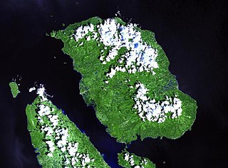
Camiguin Mindanao is a potentially active volcanic group within the Philippines.
This article does not cite any sources .(February 2020) (Learn how and when to remove this template message) |
Camiguin Mindanao is a potentially active volcanic group within the Philippines.
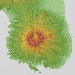
The Camiguin Mindanao Group, including Hibok-Hibok one of the active volcanoes in the Philippines, forms the volcanic island province of Camiguin, located 8 km north of central Mindanao, in the region of Northern Mindanao.
Camiguin Mindanao is about 20 kilometres (12 mi) long by 15 kilometres (9.3 mi) wide with a number of volcanoes, pyroclastic cones and craters.
The highest point in the island is the active volcano Hibok-Hibok at the northwestern end of the island, with an elevation of 1,332 metres (4,370 ft) above mean sea level (asl), and a base diameter of 10 kilometres (6.2 mi).
The other volcanos in the group are all potentially active volcanos because of their close proximity to Hibok-Hibok. Mount Vulcan is 671 m asl, on the northwestern flank of Hibok-Hibok. Mount Mambajao is located in the centre of Camiguin. Mount Ginsiliban is 581 m asl, at the southern end of Camiguin. Mount Uhay is located north of Mount Ginsiliban.
Its Domes and cones are Campana Hill, Minokol Hill, Tres Marias Hill, Mount Carling, Mount Tibane, and Piyakong Hill.
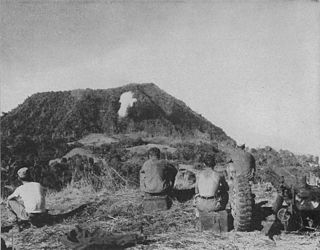
Hot springs, craters and a maar are close to Hibok-Hibok.
Solfataric activity has been a precursor to eruptions.
The most recent eruption was in the period 1948 to 1953. During this period, Hibok-Hibok formed flank lava domes and produced pyroclastic flows that devastated coastal villages.
The Camiguin Mindanao group is permanently monitored for volcanic and seismic activity.
The rock type is predominantly andesite and rhyolite.
Camiguin is the northern terminus of the Central Mindanao Arc.
All volcanoes in the Philippines are part of the Pacific ring of fire.

Mayon, also known as Mount Mayon, is an active stratovolcano in the province of Albay in Bicol Region, on the island of Luzon in the Philippines. A popular tourist spot, it is renowned for its "perfect cone" because of its symmetric conical shape, and is regarded as sacred in Philippine mythology.

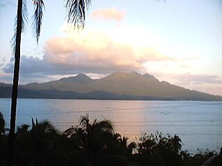
Camiguin is an island province in the Philippines located in the Bohol Sea, about 10 kilometres (6.2 mi) off the northern coast of Mindanao. It is geographically part of Region X, the Northern Mindanao Region of the country and formerly a part of Misamis Oriental province.

Didicas Volcano is an active volcanic island in the province of Cagayan in northern Philippines. The island, which was a submarine volcano and re-emerged from the sea in 1952, is 22 kilometres (14 mi) NE of Camiguin Island, one of the Babuyan Islands in Luzon Strait. Before 1952, the volcano first breached the ocean surface in 1857.
Mount Biliran is a solfataric active volcano located in the island province of Biliran in the Philippines. The volcano caused the formation of the island.
Bud Dajo, is the second highest point (+600m) in the province of Sulu, Philippines. it is one of the cinder cones that make up the island of Jolo and part of the Jolo Volcanic Group in the Republic of the Philippines. The extinct volcano is located 8 kilometres (5.0 mi) southeast from the town of Jolo in Sulu province. The mountain and adjacent lands were declared as Mount Dajo National Park in 1938.

Taal Volcano is a large caldera filled by Taal Lake in the Philippines. Located in the province of Batangas, the volcano is one of the most active volcanoes in the country, with 34 recorded historical eruptions, all of which were concentrated on Volcano Island, near the middle of Taal Lake. The caldera was formed by prehistoric eruptions between 140,000 and 5,380 BP.

Camiguin de Babuyanes is an active stratovolcano on Camiguin Island, part of the Babuyan Islands group that is located in Luzon Strait, north of the island of Luzon, in the Philippines. The volcano and the island is within the jurisdiction of the municipality of Calayan, in the province of Cagayan.

Mount Hibok-Hibok is a stratovolcano on Camiguin Island in the Philippines. It is one of the active volcanoes in the country and part of the Pacific ring of fire.

Matutum is an active volcano, approximately 5.7 kilometres (3.5 mi) from Acmonan, Tupi, South Cotabato, Philippines. Matutum and its foothills are predominantly inhabited by indigenous Blaan families.

Musuan Peak or Mount Musuan, also known as Mount Calayo is an active volcano in Maramag, Bukidnon, on the island of Mindanao in the Philippines. It is 4.5 kilometres (2.8 mi) south of the city of Valencia, province of Bukidnon, and 81 kilometres (50 mi) southeast of Cagayan de Oro City.

Mount Parker, locally known as Mélébingóy, is potentially active stratovolcano on Mindanao island in the Philippines. It is located in the province of South Cotabato, 30 kilometres (19 mi) west of General Santos City and 44 kilometres (27 mi) south of Koronadal City.
Cabalian Volcano is an active volcano located in the province of Southern Leyte in the Philippines.
Mandalagan Volcano, Mount Mandalagan is located at latitude 10.65° North (10°39'0"N), longitude 123.25° East (123°15'0"E), in the province of Negros Occidental, on the north of the island of Negros of the Philippines. It is located inside the Northern Negros Natural Park.
Mount Labo, is a potentially active stratovolcano in the province of Camarines Norte, in the Bicol Region (Region V), on Luzon Island, in the Philippines. It is located at the northwest end of the Bicol Peninsula.
Mount Natib is a dormant volcano and caldera complex in the province of Bataan on western Luzon Island of the Philippines. The volcano complex occupies the northern portion of the Bataan Peninsula. The mountain and adjacent surrounding is a protected area first declared as the Bataan National Park in 1945.
Mount Mariveles is a dormant volcano and the highest point in the province of Bataan in the Philippines. Mariveles and the adjacent Mount Natib comprise 80.9 percent of the total land area of the province. The mountain and adjacent cones lie opposite the city of Manila across Manila Bay, providing a beautiful setting for the sunsets seen from the city.

Mount Balatukan is a massive potentially active compound stratovolcano in the northern island of Mindanao, Philippines. It is the highest point in the province of Misamis Oriental. The volcano has no historical eruptions but displays fumarolic activity. The 2,450-metre (8,040 ft) mountain is topped by a triangular shaped caldera 15 kilometers (9.3 mi) long and 10.6 kilometers (6.6 mi) at its widest. The Balatocan River emanates from and drains the huge crater.
The Jolo Group of Volcanoes, more commonly referred to as the Jolo Group, are an active group of volcanoes in the island of Jolo in Southern Philippines. The Global Volcanism Program lists Jolo as one of the active volcanoes in the Philippines while the Philippine Institute of Volcanology and Seismology (PHIVOLCS) collectively list the group as Bud Dajo, one of the cinder cones on the island.
Balut Island, also known as Malulong, is a potentially active volcanic island south of the tip of Davao Occidental province in the Mindanao region, Southern Philippines. Located in the center of the island is the Balut Volcano, a fumarolic volcano with no historical eruptions.

Timpoong and Hibok-Hibok Natural Monument is a Philippine natural monument located in Northern Mindanao on the island of Camiguin. It encompasses two scenic volcanoes in the Camiguin Mindanao range that span the core of Camiguin: Mount Mambajao, which includes Mount Timpoong, its highest peak, and Mount Catarman, which includes Mount Hibok-Hibok, the island's only currently active volcano. Established in 2004 through Proclamation No. 570 issued by President Gloria Arroyo, the natural monument is an important watershed containing the only remaining rainforest on Camiguin. It supports a variety of endemic flora and fauna and is also noted for its waterfalls, rivers and springs.