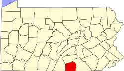
Carroll Valley, Pennsylvania

Last updated
Carroll Valley, Pennsylvania
Borough
Jacks Mtn Covered Bridge AdamsCo PA.JPG
Adams County Pennsylvania incorporated and unincorporated areas Carroll Valley highlighted.svg
Location in Adams County and the U.S. state of Pennsylvania.
USA Pennsylvania location map.svg
Red pog.svg
Carroll Valley
Location in Pennsylvania and the United States
Usa edcp location map.svg
Red pog.svg
Carroll Valley
Carroll Valley (the United States)
Coordinates: 39°44′52″N77°22′44″W / 39.74778°N 77.37889°W / 39.74778; -77.37889 Coordinates: 39°44′52″N77°22′44″W / 39.74778°N 77.37889°W / 39.74778; -77.37889
Country United States
State Pennsylvania
County Adams
Incorporated1974
Government
  TypeBorough Council
  MayorRonald J. Harris
Area
[1]
  Total5.45 sq mi (14.12 km2)
  Land5.38 sq mi (13.93 km2)
  Water0.07 sq mi (0.19 km2)
Elevation
807 ft (246 m)
Population
 (2020) [2]
  Total3,940
  Density732.75/sq mi (282.91/km2)
Time zone UTC-5 (Eastern (EST))
  Summer (DST) UTC-4 (EDT)
Zip Code
17320 (Fairfield)
Area code 717
FIPS code 42-11472
Website www.carrollvalley.org

Carroll Valley is a borough in Adams County, Pennsylvania, United States. The population was 3,940 at the 2020 census. [3]

Contents

Geography

Carroll Valley is located at 39°44′52″N77°22′44″W / 39.74778°N 77.37889°W / 39.74778; -77.37889 (39.747668, -77.378846). [4] According to the U.S. Census Bureau, the borough has a total area of 5.5 square miles (14 km2), of which 5.4 square miles (14 km2) is land and 0.1 square miles (0.26 km2) (1.10%) is water.

Demographics

Historical population
CensusPop.Note
1980 817
1990 1,45778.3%
2000 3,291125.9%
2010 3,87617.8%
2020 3,9401.7%
Sources: [5] [6] [7] [2]

As of the census [6] of 2000, there were 3,291 people, 1,176 households, and 952 families residing in the borough. The population density was 610.4 people per square mile (235.7/km²). There were 1,261 housing units at an average density of 233.9 per square mile (90.3/km²). The racial makeup of the borough was 96.81% White, 0.61% African American, 0.43% Native American, 0.40% Asian, 0.24% from other races, and 1.52% from two or more races. Hispanic or Latino of any race were 0.79% of the population.

There were 1,176 households, out of which 43.5% had children under the age of 18 living with them, 71.9% were married couples living together, 5.6% had a female householder with no husband present, and 19.0% were non-families. 14.0% of all households were made up of individuals, and 4.0% had someone living alone who was 65 years of age or older. The average household size was 2.80 and the average family size was 3.08.

In the borough, the population was spread out, with 29.7% under the age of 18, 4.9% from 18 to 24, 35.2% from 25 to 44, 21.6% from 45 to 64, and 8.7% who were 65 years of age or older. The median age was 35 years. For every 100 females there were 100.4 males. For every 100 females age 18 and over, there were 101.3 males.

The median income for a household in the borough was $54,659, and the median income for a family was $55,000. Males had a median income of $40,135 versus $27,090 for females. The per capita income for the borough was $21,286. About 1.7% of families and 2.2% of the population were below the poverty line, including 2.0% of those under age 18 and 2.5% of those age 65 or over.

Parks and recreation

Carroll Valley Borough has three lakes (two offer public fishing and boating), two recreation areas, several auxiliary playing fields and a pavilion with picnic area. Carroll Commons hosts a large playground, picnic area and a pavilion. The park has a beach volleyball court, basketball court, bocce court, horseshoe pits, and shuffle board. Public restroom facilities are open from dawn to dusk daily on the Commons grounds from April 15 until October 1.

Related Research Articles

<span class="mw-page-title-main">Union Bridge, Maryland</span> Town in Maryland, United States

Union Bridge is a town in Carroll County, Maryland, United States. The population was 936 at the 2020 census.

<span class="mw-page-title-main">Arendtsville, Pennsylvania</span> Borough in Pennsylvania, United States

Arendtsville is a borough in Adams County, Pennsylvania, United States. The borough lies on Pennsylvania Route 234 and is well known for its annual Apple Harvest Festival in the fall. The population was 867 at the 2020 census.

<span class="mw-page-title-main">Bendersville, Pennsylvania</span> Borough in Pennsylvania, United States

Bendersville is a borough in Adams County, Pennsylvania, United States. The population was 736 at the 2020 census.

<span class="mw-page-title-main">Bonneauville, Pennsylvania</span> Borough in Pennsylvania, United States

Bonneauville is a borough in Adams County, Pennsylvania, United States. The population was 1,758 at the 2020 census.

<span class="mw-page-title-main">Liberty Township, Adams County, Pennsylvania</span> Township in Pennsylvania, United States

Liberty Township is a township that is located in Adams County, Pennsylvania, United States. The population was 1,237 at the time of the 2010 census.

<span class="mw-page-title-main">Centre Hall, Pennsylvania</span> Borough in Pennsylvania, United States

Centre Hall is a borough in Centre County, Pennsylvania, United States. It is located in Penns Valley and is part of the State College, Pennsylvania Metropolitan Statistical Area. The population was 1,265 at the 2010 census, which is a 17.2% increase from the 2000 census.

<span class="mw-page-title-main">Knox Township, Clarion County, Pennsylvania</span> Township in Pennsylvania, United States

Knox Township is a township that is located in Clarion County, Pennsylvania, United States. As of the 2020 census, the township population was 997, a decrease from the figure of 1,036 that was tabulated in 2010.

<span class="mw-page-title-main">Avis, Pennsylvania</span> Borough in Pennsylvania, United States

Avis is a borough in Clinton County, Pennsylvania, United States. The population was 1,484 at the 2010 census.

<span class="mw-page-title-main">Blooming Valley, Pennsylvania</span> Borough in Pennsylvania, United States

Blooming Valley is a borough in Crawford County, Pennsylvania, United States. The population was 344 at the 2020 census, up from 337 at the 2010 census.

<span class="mw-page-title-main">Markleysburg, Pennsylvania</span> Borough in Pennsylvania, United States

Markleysburg is a borough in Fayette County, Pennsylvania, United States. The population was 246 at the 2020 census. The borough is served by the Uniontown Area School District.

<span class="mw-page-title-main">Mont Alto, Pennsylvania</span> Borough in Pennsylvania, United States

Mont Alto is a borough in Franklin County, Pennsylvania, United States. The population was 1,580 at the 2020 census.

<span class="mw-page-title-main">McConnellsburg, Pennsylvania</span> Borough in Pennsylvania, United States

McConnellsburg is a borough in Fulton County, Pennsylvania, United States. The population was 1,150 at the 2020 census. It is the county seat of Fulton County.

<span class="mw-page-title-main">Mill Creek, Pennsylvania</span> Borough in Pennsylvania, United States

Mill Creek is a borough in Huntingdon County, Pennsylvania, United States. The population was 328 at the 2010 census.

<span class="mw-page-title-main">Blain, Pennsylvania</span> Borough in Pennsylvania, United States

Blain is a borough in Perry County, Pennsylvania, United States. The population was 227 at the 2020 census. It is part of the Harrisburg metropolitan area. Blain is located in a valley region known as Sherman's Valley.

<span class="mw-page-title-main">Carroll Township, Perry County, Pennsylvania</span> Township in Pennsylvania, United States

Carroll Township is a second class township in Perry County, Pennsylvania, United States. The population was 5,230 at the 2020 census. It is one of twenty-two (22) townships in Perry County and one of 1,456 townships in the Commonwealth of Pennsylvania.

<span class="mw-page-title-main">Liverpool Township, Perry County, Pennsylvania</span> Township in Pennsylvania, United States

Liverpool Township is a township in Perry County, Pennsylvania, United States. The population was 1,037 at the 2020 census. It is not to be confused with the borough of Liverpool, which is adjacent.

<span class="mw-page-title-main">Newport, Pennsylvania</span> Borough in Pennsylvania, United States

Newport is a borough in Perry County, Pennsylvania, United States. The population was 1,487 at the 2020 census. It is part of the Harrisburg–Carlisle Metropolitan Statistical Area.

<span class="mw-page-title-main">Mansfield, Pennsylvania</span> Borough in Pennsylvania, United States

Mansfield is a borough located in east-central Tioga County, Pennsylvania, United States, in the Tioga River valley. It is situated at the intersection of U.S. Route 6 and U.S. Business Route 15, about 36 miles (58 km) southwest of Elmira, New York.

<span class="mw-page-title-main">Carroll Township, York County, Pennsylvania</span> Township in Pennsylvania, United States

Carroll Township is a township in York County, Pennsylvania, United States. The population was 6,853 at the 2020 census.

<span class="mw-page-title-main">Cross Roads, Pennsylvania</span> Borough in Pennsylvania, United States

Cross Roads is a borough in York County, Pennsylvania, United States. The population was 524 at the 2020 census. The crossroads in the borough is where Church Road intersects Cross Roads Avenue and are joined by Century Farms Road. East of the intersection, Century Farms Road is numbered SR 2050 and Church Road is unnumbered.

References

  1. "ArcGIS REST Services Directory". United States Census Bureau. Retrieved October 12, 2022.
  2. 1 2 "Census Population API". United States Census Bureau. Retrieved Oct 12, 2022.
  3. "Explore Census Data".
  4. "US Gazetteer files: 2010, 2000, and 1990". United States Census Bureau. 2011-02-12. Retrieved 2011-04-23.
  5. "Census of Population and Housing". U.S. Census Bureau. Retrieved 11 December 2013.
  6. 1 2 "U.S. Census website". United States Census Bureau . Retrieved 2008-01-31.
  7. "Incorporated Places and Minor Civil Divisions Datasets: Subcounty Resident Population Estimates: April 1, 2010 to July 1, 2012". Population Estimates. U.S. Census Bureau. Archived from the original on 11 June 2013. Retrieved 11 December 2013.