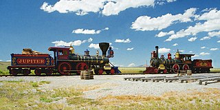
Golden Spike National Historical Park is a U.S. National Historical Park located at Promontory Summit, north of the Great Salt Lake in east-central Box Elder County, Utah, United States. The nearest city is Corinne, approximately 23 miles (37 km) east-southeast of the site.

This is a directory of properties and districts listed on the National Register of Historic Places in Utah, USA. There are more than 1,800 listed properties in Utah. Each of the 29 counties in Utah has at least two listings on the National Register.

Buildings, sites, districts, and objects in California listed on the National Register of Historic Places:

There are 447 properties and historic districts listed on the National Register of Historic Places in North Dakota. There are listings in 52 of North Dakota's 53 counties.

This is a list of the properties and historic districts in each of the 46 counties of South Carolina that are designated National Register of Historic Places.

Emigration Canyon is a census-designated place (CDP), township and canyon in Salt Lake County, Utah, United States, located east of Salt Lake City in the Wasatch Range. Beginning at the southern end of the University of Utah, the canyon itself heads east and northeast between Salt Lake City and Morgan County. The boundaries of the CDP and township are coextensive; they do not extend to the county line. As of the 2010 census, the population was 1,567.

The First American Road in Florida is a historic road near Gulf Breeze, Florida. It is located in the Naval Live Oaks Area of the Gulf Islands National Seashore. On September 28, 1998, it was added to the U.S. National Register of Historic Places.

East Rock Park is a park in the city of New Haven and the town of Hamden, Connecticut that is operated as a New Haven city park. The park surrounds and includes the mountainous ridge named East Rock and was developed with naturalistic landscaping. The entire 427-acre (173 ha) park is listed on the National Register of Historic Places.

The Hole in the Rock Trail is a historic trail running east-southeast from the town of Escalante in southern Utah in the western United States. The Mormon trailblazers who established this trail crossed the Colorado River and ended their journey in the town of Bluff. The Hole-in-the-Rock expedition established the trail in 1879. The trail is located within the borders of the Grand Staircase-Escalante National Monument, the adjacent Glen Canyon National Recreation Area and federal Bureau of Land Management (BLM) public land to the east of the Colorado River. A geologic feature called the Hole in the Rock gave the trail its name. A modern unpaved road called the Hole-in-the-Rock Road closely follows this historic trail to the point where it enters the Glen Canyon National Recreation Area. The modern road is an important access route for visiting the Canyons of the Escalante and the Devil's Garden. The trail is listed on the National Register of Historic Places, being added to that list in 1982.

Military Road is a central thoroughfare located in Omaha, Nebraska. A segment of the road located at the junction of West 82nd and Fort Streets was listed on the National Register of Historic Places in 1993. Today Military Road, which begins at Nebraska Highway 64 as Nebraska Highway L-28K, ends at Bennington Road near North 204th Street.

The Serpents Trail, also known as the Trail of the Serpents and the Serpentine Trail, is a trail within the Colorado National Monument in Mesa County, Colorado, United States, that is listed on the National Register of Historic Places.

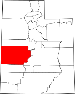
This is a list of the National Register of Historic Places listings in Box Elder County, Utah.
This is a list of the National Register of Historic Places listings in Millard County, Utah.

The historical buildings and structures of Zion National Park represent a variety of buildings, interpretive structures, signs and infrastructure associated with the National Park Service's operations in Zion National Park, Utah. Structures vary in size and scale from the Zion Lodge to road culverts and curbs, nearly all of which were designed using native materials and regional construction techniques in an adapted version of the National Park Service Rustic style. A number of the larger structures were designed by Gilbert Stanley Underwood, while many of the smaller structures were designed or coordinated with the National Park Service Branch of Plans and Designs. The bulk of the historic structures date to the 1920s and 1930s. Most of the structures of the 1930s were built using Civilian Conservation Corps labor.
Christman Bird and Wildlife Sanctuary is a national historic district located near Delanson, Schenectady County, New York. The district includes six contributing buildings and one contributing structure on a largely wooded, rural 105-acre (42 ha) tract. It lies in the valley of the Bozenkill and includes a 30-foot (9.1 m) waterfall along the Helderberg Escarpment. Located on the property is a two-story frame dwelling built in 1868, a stone dairy house, barns, large stone walls, and an open lean-to built by the Mohawk Valley Hiking Club. The sanctuary had its beginnings in 1888 when property owner W.W. Christman (1865-1937) and his wife, the former Catherine Bradt, began a winter bird feeding program during the great blizzard of that year.

The Provo East Central Historic District is a 260-acre (110 ha) historic district in Provo, Utah, United States that was listed on the National Register of Historic Places in 1998.
The Brow Monument is a monument listed in the National Register of Historic Places for Coconino County, Arizona, located in the Kaibab National Forest. The site contains one of the few remaining survey markers used by the expedition of John Wesley Powell in 1872 It is accessible via the Brow Monument Trail.

Dodd Road Discontiguous District near Forest Township, Rice County, Minnesota is a set of three road segments which were listed on the National Register of Historic Places in 2003. They preserve segments of Dodd Road, a private road built by William B. Dodd. It was a privately funded road built between Mendota and St. Peter in 1853, and was a key transportation artery in early south-central Minnesota.

The Jacksonville-to-Fort Klamath Military Wagon Road, from Jacksonville, Oregon to Fort Klamath Fort Klamath, Oregon, was built in 1863 by the U.S. Department of the Army. Segments of the road were listed on the National Register of Historic Places in 1979. The listing included four contributing structures.

The James Bean Decker House, at 189 N. 300 East, in Bluff, Utah, was built in 1898. It was listed on the National Register of Historic Places in 1983. It is also a contributing building in the National Register-listed Bluff Historic District.


