Union Village or "Bank Village" is a village and historic district located in North Smithfield and Woonsocket, Rhode Island on Rhode Island Route 146A. Union Village developed because it was at the cross roads of old Great Road and Pound Hill Road.

Allen Street Historic District is a historic district encompassing a collection of smaller textile mills in central Woonsocket, Rhode Island. The district extends on either side of Allen Street, a road isolated between Truman Drive and the Blackstone River, and includes buildings dating from c. 1860 to c. 1930. Of the five textile mill buildings in the district, four are brick structures built between about 1900 and 1920; the oldest building in the district is the c. 1860 Pond's Warp Mill at 148 Bernon Street. The latter is also adjacent to a rare visible fragment of the once-extensive canal works that characterized the industrial center of Woonsocket. Many of the district's buildings have been converted to housing.

The Alphonse Gaulin Jr. House is an historic house on 311 Elm Street in Woonsocket, Rhode Island. The 2 1⁄2-story wood-frame house was built c. 1885 by Alphonse Gaulin Jr., one of the city's first wealthy French-Canadian residents and its mayor 1903-05. The house is one of the city's finest Queen Anne Victorians, exhibiting the asymmetrical massing, varying projections, and a square tower projecting diagonally from one corner.

Honan's Block and 112—114 Main Street are a pair of joined commercial buildings at 110-114 Main Street in Woonsocket, Rhode Island. Honan's Block is a visually distinctive three-story brick Stick/Eastlake-style building erected in 1879. The adjacent 112-114 Main Street is an L-shaped two-story block which wraps around the rear of the Honan Block. The two buildings were joined via internal connections in 1938-39, at which time the facades of both buildings were significantly altered, although the Honan Block has retained its distinctive Late Victorian cast-iron elements.

The Island Place Historic District is a historic district at Island Place and South Main Street at Market Square in Woonsocket, Rhode Island. The district includes six historic buildings, three of which are part of the Woonsocket Rubber Company Mill, dating from c. 1857 to c. 1919. The other buildings in the district are the Island Machine Company, the Barnai Worsted Company Dyeworks, and a wood-frame structure, that is the last surviving elements of the Wilkins Manufacturing Company. The district is bounded by Market Square, Bernon Street, and a bend in the Blackstone River. The site is now home to the Museum of Work & Culture, a project of the Rhode Island Historical Society.

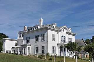
The Jenckes Mansion is an historic house at 837 Social Street in Woonsocket, Rhode Island. This three-story brick double house was built in 1828 by the Jenckes family, owners of the mills around which this area of Woonsocket, known as Jenckesville, grew. The building exhibits late Federal styling, and is distinctive as a rare example of a period private residence with ballroom. This space, located on the building's attic space, was divided into residential spaces c. 1900, when the building was converted into a tenement house.

The Main Street Historic District is a historic district in the central business district of Woonsocket, Rhode Island, USA. It extends along Main Street, between the railroad tracks just northeast of its junction with Clinton Street, and roughly Ascension Street at the southwest. Most of the sixteen buildings in this area were built at the height of Woonsocket's prosperity, roughly between 1850 and 1930. The district is characterized by brick and masonry buildings generally between two and six stories in height.
The North End Historic District is a historic district in Woonsocket, Rhode Island encompassing an affluent residential area developed predominantly between about 1880 and 1930. It is bounded by Harris Avenue on the west, Winter Street on the north, Summer and Prospect Streets to the east, and Spring and Blackstone Streets to the south. It is separated from Woonsockets commercial and industrial heart by a neighborhood of densely populated worker housing. Most of the district's 224 major buildings are of relatively high quality and in good condition, and are reflective of the architectural styles that predominated in the late 19th and early 20th centuries: Queen Anne Victorian, Colonial Revival, and Tudor Revival forms and styles are the most common seen.
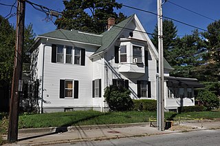
The Pothier House is a historic house at 172 Pond Street in Woonsocket, Rhode Island. This modest L-shaped 1-1/2 story cottage is notable as the longtime home of Woonsocket mayor Aram J. Pothier. Pothier's father purchased the house c. 1881, and it was the younger Pothier's home until his death in 1928.

Woonsocket Rubber Company Mill is an historic mill at 60-82 Main Street in Woonsocket, Rhode Island. The mill consists of a series of 3- and 4-story brick buildings built between 1865 and 1875 by Edward Harris, one of Woonsocket's leading businessmen. These buildings housed the Woonsocket Rubbert Company, one of Rhode Island's first manufacturer of rubber products, principally shoes, boots, and rubberized fabric. In 1910 the complex was purchased by the Falls Yarn Company, which used it for the production of fine woolen yarns.

The Woonsocket District Courthouse is an historic court building on 24 Front Street in Woonsocket, Rhode Island.

The Woonsocket Company Mill Complex is a historic district encompassing one of the largest mill complexes in Woonsocket, Rhode Island. The district includes all of the buildings historically associated with the Woonsocket Company, a major manufacturer of cotton textiles in the 19th century. The complex is located along the eastern bank of the Blackstone River between Court and Bernon Streets. It includes three handsome stone mills, built between 1827 and 1859, and a power plant that was built on the site of the former #3 mill between 1890 and 1920, as well as the remnants of the canal that originally carried water to the buildings for power.

The St. Charles Borromeo Church Complex is an historic Roman Catholic Church in Woonsocket, Rhode Island on North Main Street within the Diocese of Providence.

St. Ann's Church Complex is now a historic cultural center in Woonsocket, Rhode Island on Cumberland Street. It was formerly a Roman Catholic church within the Diocese of Providence.

St. Andrew's Episcopal Chapel is an historic Episcopal church located at 576 Fairmont Street in Woonsocket, Rhode Island.

The South Main Street Historic District is a residential historic district in Woonsocket, Rhode Island. It extends along South Main Street between Mason Street on one end and Andrews and Bradford Streets on the other, and includes properties on adjacent streets, principally Ballou and North Ballou Streets. The district includes 65 main properties, most of which were built between 1880 and 1930, although there is a cluster of older properties in the northern half of the district. The district typifies the American main road leading into a town, lined by landscaped lots with high-quality houses.

The U.S. Post Office is a historic former post office building at 295 Main Street in Woonsocket, Rhode Island. The single-story masonry building was built 1910-12 and served as Woonsocket's main post office until 1975.

The Wayland Historic District is a predominantly residential historic district on the east side of Providence, Rhode Island. It is a large area, covering about 122 acres (49 ha), bounded roughly on the north by Everett and Laurel Avenues, on the east by Blackstone Boulevard and Butler Avenue, on the west by Arlington Avenue, and on the south by Angell and South Angell Streets. This area, which was in the 19th century part of the Moses Brown farm, was platted for development in 1891, with most of the construction taking place in the early decades of the 20th century. Most of the residential properties in the district are single-family houses, typically built in revival styles popular at the time. They are set on similarly-sized lots with fairly uniform setbacks, and were typically built without garages. There are a number of two-family houses, and a small number of apartment buildings, most of which are found on the arterial roads of the area. There are several religious buildings, including several churches; the most architecturally distinctive religious building is the Jewish Temple Beth El, built 1951-54.

The Fifth Ward Wardroom is a historic meeting hall at 47 Mulberry Street in Pawtucket, Rhode Island. It is a single-story red brick building, with a low-pitch hipped roof. Basically rectangular, an enclosed entry pavilion projects from the main block. The building was designed by William R. Walker & Son and built in 1886. Originally used as a polling place and meeting hall, it was later used as a school and by veterans organizations before being converted into a single family residence during its National Register of Historic Places nomination. It was listed on the historic register in 1983.
This is a list of National Register of Historic Places listings in Woonsocket, Rhode Island.