Central Square, Boston

Last updated
Librarian at work in the East Boston branch of the Boston Public Library 2008 public library East Boston 3011072596.jpg
Librarian at work in the East Boston branch of the Boston Public Library
The Trinity Neighborhood House located at 406 Meridian Street Trinity Neighborhood House, East Boston MA.jpg
The Trinity Neighborhood House located at 406 Meridian Street

Central Square is a section of the neighborhood of East Boston in Boston, Massachusetts, United States. The square begins at the intersection of Bennington Street and Meridian Street, continues up Meridian to its intersection with White Street, and includes all the area to the left. The square’s intersecting streets also include Border, Saratoga, and Eutaw Street. It is within close proximity of the entrance to the Sumner Tunnel, which motorists take to downtown Boston.

East Boston Neighborhood of Boston in Suffolk, Massachusetts, United States

East Boston, nicknamed Eastie, is a neighborhood of Boston, Massachusetts with over 40,000 residents. The neighborhood was created by connecting several islands using land fill. It was annexed by Boston in 1836. It is separated from downtown Boston by Boston Harbor and bordered by Winthrop, Revere, and the Chelsea Creek. Southwest of East Boston, across Boston Inner Harbor, is the North End and Boston's Financial District. The neighborhood is easily accessible to downtown Boston via the MBTA Blue Line.

Boston Capital city of Massachusetts, United States

Boston is the capital and most populous city of the Commonwealth of Massachusetts in the United States. The city proper covers 48 square miles (124 km2) with an estimated population of 685,094 in 2017, making it also the most populous city in New England. Boston is the seat of Suffolk County as well, although the county government was disbanded on July 1, 1999. The city is the economic and cultural anchor of a substantially larger metropolitan area known as Greater Boston, a metropolitan statistical area (MSA) home to a census-estimated 4.8 million people in 2016 and ranking as the tenth-largest such area in the country. As a combined statistical area (CSA), this wider commuting region is home to some 8.2 million people, making it the sixth-largest in the United States.

Massachusetts State of the United States of America

Massachusetts, officially the Commonwealth of Massachusetts, is the most populous state in the New England region of the northeastern United States. It borders on the Atlantic Ocean to the east, the states of Connecticut and Rhode Island to the south, New Hampshire and Vermont to the north, and New York to the west. The state is named after the Massachusett tribe, which once inhabited the east side of the area, and is one of the original thirteen states. The capital of Massachusetts is Boston, which is also the most populous city in New England. Over 80% of Massachusetts's population lives in the Greater Boston metropolitan area, a region influential upon American history, academia, and industry. Originally dependent on agriculture, fishing and trade, Massachusetts was transformed into a manufacturing center during the Industrial Revolution. During the 20th century, Massachusetts's economy shifted from manufacturing to services. Modern Massachusetts is a global leader in biotechnology, engineering, higher education, finance, and maritime trade.

Contents

Education

The Mario Umana Middle School Academy is the only school within the confines of Central Square, located at 312 Border Street. [1] It is part of the Boston Public Schools system. Notably, the school's campus features the only recognized skate park in the neighborhood, the Harborside Community Skatepark. [2] The first public branch library in the United States, built in 1870, lies in Central Square. Boston Public Library's East Boston branch is located at 276 Meridian Street. [3]

Boston Public Schools public school system of Boston

Boston Public Schools (BPS) is a school district serving the city of Boston, Massachusetts, United States.

Boston Public Library library in Boston, USA

The Boston Public Library is a municipal public library system in Boston, Massachusetts, United States, founded in 1848. The Boston Public Library is also the Library for the Commonwealth of the Commonwealth of Massachusetts; all adult residents of the commonwealth are entitled to borrowing and research privileges, and the library receives state funding. The Boston Public Library contains approximately 24 million volumes, and electronic resources, making it the third-largest public library in the United States behind only the Library of Congress and the New York Public Library. In fiscal year 2014, the library held over 10,000 programs, all free to the public, and lent 3.7 million materials.

Sites of interest

Italia Unita festival

Central Square is the site of the annual Italia Unita festival, where the square is closed off for festivities. Live bands play and food carts serve the crowds. [4]

Liberty Plaza

The Lombardo family invested heavily to create a shopping district in Central Square. They began with a function hall named Lombardo's Function Facility and expanded to create what is now called Liberty Plaza, the square's strip mall. They expanded with a large supermarket, Liberty Market. In 2000, the family moved their business to Randolph, Massachusetts, but the shopping plaza is still active and vibrant. [5] The entrance to the Plaza features a small park, known as Bertulli Park or Central Square Park, which doubles as a rotary. Today, stores include CVS Pharmacy, Marshalls, Radio Shack, Shaw's Supermarket, including eateries such as McDonald's and Pollo Campero.

Strip mall Open-air shopping mall

A strip mall is an open-air shopping mall where the stores are arranged in a row, with a sidewalk in front. Strip malls are typically developed as a unit and have large parking lots in front. They face major traffic arterials and tend to be self-contained with few pedestrian connections to surrounding neighborhoods.

Randolph, Massachusetts City in Massachusetts, United States

The Town of Randolph is a suburban city in Norfolk County, Massachusetts, United States. At the 2010 census, the town population was 32,158. Randolph adopted a new charter effective January 2010 providing for a council-manager form of government instead of the traditional town meeting. Randolph is one of thirteen Massachusetts municipalities that have applied for, and been granted, city forms of government but wish to retain "The town of” in their official names.

CVS Pharmacy U.S. pharmacy chain

CVS Pharmacy is a subsidiary of the American retail and health care company CVS Health, headquartered in Woonsocket, Rhode Island. It was also known as, and originally named, the Consumer Value Store and was founded in Lowell, Massachusetts, in 1963. The chain was owned by its original holding company Melville Corporation since its inception until its current parent company was spun off into its own company in 1996. CVS Pharmacy is currently the largest pharmacy chain in the United States by number of locations and total prescription revenue. Its parent company ranks as the 7th largest U.S. corporation by FY2017 revenues in the Fortune 500. The parent company of CVS Pharmacy's leading competitor ranked 19th for the same time period.

Trinity Neighborhood House

The Trinity Neighborhood House is a historic brick townhouse at 406 Meridian Street. Since 1888, it operated as a social service center and philanthropy of Trinity Church. [6] In 1966, the House was taken over by the East Boston Social Centers. Today, it has been converted into Section 8 housing for the disabled and formerly homeless. [7] In 1981, the Boston Landmarks Commission declared it a landmark and it was later added to the National Register of Historic Places in 1992.

Trinity Neighborhood House

The Trinity Neighborhood House is a historic brick townhouse at 406 Meridian Street located in the Eagle Hill section of East Boston, Massachusetts.

A historic house generally meets several criteria before being listed by an official body as "historic." Generally the building is at least a certain age, depending on the rules for the individual list. A second factor is that the building be in recognizably the same form as when it became historic. Third is a requirement that either an event of historical importance happened at the site, or that a person of historical significance was associated with the site, or that the building itself is important for its architecture or interior.

Brick Block or a single unit of a ceramic material used in masonry construction

A brick is building material used to make walls, pavements and other elements in masonry construction. Traditionally, the term brick referred to a unit composed of clay, but it is now used to denote any rectangular units laid in mortar. A brick can be composed of clay-bearing soil, sand, and lime, or concrete materials. Bricks are produced in numerous classes, types, materials, and sizes which vary with region and time period, and are produced in bulk quantities. Two basic categories of bricks are fired and non-fired bricks.

Related Research Articles

Kendall Square human settlement in United States of America

Kendall Square is a neighborhood in Cambridge, Massachusetts, U.S., with the square itself at the intersection of Main Street and Broadway. It also refers to the broad business district east of Portland Street, northwest of the Charles River, north of MIT and south of Binney Street. Kendall Square has been called "the most innovative square mile on the planet," in reference to the high concentration of entrepreneurial start-ups and quality of innovation which have emerged in the vicinity of the square since 2010.

South End, Boston human settlement in the United States of America

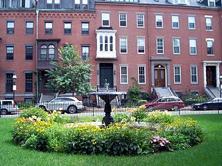
The South End is a neighborhood of Boston, Massachusetts. It is bordered by Back Bay, Chinatown, and Roxbury. It is distinguished from other neighborhoods by its Victorian style houses and the many parks in and around the area. The South End is the largest intact Victorian row house district in the country, which is made up of over 300 acres. Eleven residential parks are scattered around the South End. In 1973, the South End was listed in the National Register of Historic Places. The construction of the South End began in 1849 when the neighborhood was built on tidal marshes.

Back Bay, Boston neighborhood in Boston, Massachusetts

Back Bay is an officially recognized neighborhood of Boston, Massachusetts. It is most famous for its rows of Victorian brownstone homes—considered one of the best preserved examples of 19th-century urban design in the United States—as well as numerous architecturally significant individual buildings, and cultural institutions such as the Boston Public Library. It is also a fashionable shopping destination and home to Boston's tallest office buildings, the Hynes Convention Center, and numerous major hotels.

Copley Square square in Back Bay, Boston, Massachusetts

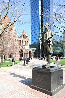
Copley Square, named for painter John Singleton Copley, is a public square in Boston's Back Bay neighborhood, bounded by Boylston Street, Clarendon Street, St. James Avenue, and Dartmouth Street. Prior to 1883 it was known as Art Square due to its many cultural institutions, some of which remain today. It is a pending Boston Landmark.

Fenway–Kenmore Neighborhood in Boston in Suffolk, Massachusetts, United States

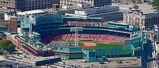
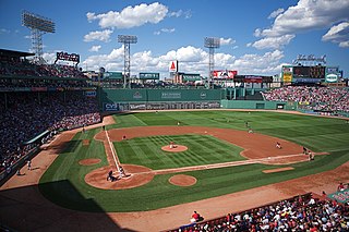
Fenway–Kenmore is an officially recognized neighborhood of Boston, Massachusetts. While it is considered one neighborhood for administrative purposes, it is composed of numerous distinct sections that, in casual conversation, are almost always referred to as "Fenway", "the Fenway", "Kenmore Square", or "Kenmore". Furthermore, the Fenway neighborhood is divided into two sub-neighborhoods commonly referred to as East Fenway/Symphony and West Fenway.

Roslindale Neighborhood of Boston in Suffolk, Massachusetts, United States

Roslindale is a primarily residential neighborhood of Boston, Massachusetts, bordered by Jamaica Plain, Hyde Park, West Roxbury and Mattapan. It is served by an MBTA Commuter Rail line, several MBTA bus lines and the MBTA Orange Line in nearby Jamaica Plain. Roslindale has its own branch of the Boston Public Library, the neighborhood is covered by Boston Police District E-5 in West Roxbury, Boston EMS Ambulance 17 is stationed in Roslindale, and the Boston Fire Department has a station on Canterbury Street which houses Ladder 16, Engine 53 & District Chief 12. Roslindale's original Engine Company 45, was deactivated on April 10, 1981, due to budget cuts. The portion of the Arnold Arboretum south of Bussey Street is located in Roslindale.

Tremont Street subway Boston subway tunnel

The Tremont Street subway in Boston's MBTA Subway system is the oldest subway tunnel in North America and the third oldest still in use worldwide to exclusively use electric traction, opening on September 1, 1897. It was originally built to get streetcar lines off the traffic-clogged streets, instead of as a true rapid transit line. It now forms the central part of the Green Line, connecting Boylston Street to Park Street and Government Center stations.

Newtonville, Massachusetts village in Massachusetts

Newtonville is a village of Newton, Massachusetts.

Hawthorne, Philadelphia Neighborhood of Philadelphia in Philadelphia County, Pennsylvania, United States

Hawthorne is a neighborhood in the South Philadelphia section of Philadelphia, Pennsylvania. It is located between Broad Street and 11th Street, and extends from South Street to Washington Avenue.

Maverick Square is a section of the neighborhood of East Boston in Boston, Massachusetts, United States. The square is intersected by several thoroughfares, but is most notably recognized by the convergence of Chelsea Street and Meridian Street. At the heart of the square is Maverick Station, which is part of the Blue Line of the MBTA.

Boylston Street major street in Boston, Massachusetts, USA

Boylston Street is the name of a major east-west thoroughfare in the city of Boston, Massachusetts. The road begins in Boston's Fenway neighborhood, runs through Back Bay, forms the southern border of the Boston Public Garden and Boston Common, and ends in Downtown Boston.

Park Square in downtown Boston, Massachusetts is bounded by Stuart, Charles Street South, Boylston, and Arlington Streets. It is the home of the Boston Four Seasons Hotel, the Boston Park Plaza, and nearly a dozen restaurants. To the north across Boylston Street is the Boston Public Garden. To the east is the Washington Street Theatre District. The Bay Village neighborhood is to the south, and Back Bay is to the west.

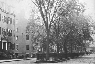
Chester Square is a residential garden square located along Massachusetts Avenue in Boston, between Tremont Street and Shawmut Avenue. The name "Chester" is derived from the original name of the street, which was renamed Massachusetts Avenue on March 1, 1894. Chester Park is also located in the historic South End of Boston.

Downtown Boston Area of Boston Massachusetts

Downtown Boston is the central business district of Boston, Massachusetts, United States. The city of Boston was founded in 1630. The largest of the city's commercial districts, Downtown is the location of many corporate or regional headquarters; city, county, state and federal government facilities; and many of Boston's tourist attractions. Similar to other central business districts in the U.S., Downtown has recently undergone a transformation that included the construction of new condos and lofts, renovation of historic buildings, and arrival of new residents and businesses. It is represented in the Boston City Council by District 2's Bill Linehan.

South Quincy

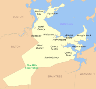
South Quincy is a neighborhood of Quincy, Massachusetts. Located in the south central portion of the city, South Quincy is bordered on the north by Quincy Center and West Quincy, on the east by Quincy Avenue and the Quincy Point neighborhood, on the south by Braintree and on the west by Interstate 93.

Franklin and Blackstone Squares

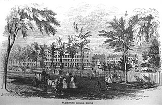
Blackstone and Franklin Squares are public parks located in the South End neighborhood of Boston, Massachusetts.

Pemberton Square

Pemberton Square in the Government Center area of Boston, Massachusetts, was developed by P.T. Jackson in the 1830s as an architecturally uniform mixed-use enclave surrounding a small park. In the mid-19th century both private residences and businesses dwelt there. The construction in 1885 of the massive John Adams Courthouse changed the scale and character of the square, as did the Center Plaza building in the 1960s.

References

  1. http://www.bostonpublicschools.org/school/mario-umana-academy
  2. "Archived copy". Archived from the original on 2013-06-23. Retrieved 2013-03-23.
  3. "East Boston Branch". Boston Public Library. Archived from the original on January 5, 2013. Retrieved March 18, 2013.
  4. Italia Unita website
  5. https://web.archive.org/web/20100830050613/http://www.boston.com/news/local/massachusetts/articles/2010/07/27/east_boston_excited_about_restoration_plans/. Archived from the original on August 30, 2010.Missing or empty |title= (help)
  6. Conte, Frank (August 19, 2012). "Boston Landmark Trinity Neighborhood House". EastBoston.com.
  7. Fox, Jeremy C. (August 17, 2011). "United Way volunteers clean up Trinity Neighborhood House". Boston.com.

See also

Coordinates: 42°22′38″N71°02′24″W / 42.3771°N 71.0401°W / 42.3771; -71.0401

Geographic coordinate system Coordinate system

A geographic coordinate system is a coordinate system that enables every location on Earth to be specified by a set of numbers, letters or symbols. The coordinates are often chosen such that one of the numbers represents a vertical position and two or three of the numbers represent a horizontal position; alternatively, a geographic position may be expressed in a combined three-dimensional Cartesian vector. A common choice of coordinates is latitude, longitude and elevation. To specify a location on a plane requires a map projection.