Dock Square (Boston)

Last updated
Dock Square, Boston, c. 1840s; Old Feather Store (at left) and Faneuil Hall (in middle) 1845 FaneuilHall ArthursMagazine July.png
Dock Square, Boston, c. 1840s; Old Feather Store (at left) and Faneuil Hall (in middle)

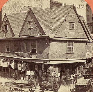
Dock Square in downtown Boston, Massachusetts is a public square adjacent to Faneuil Hall, bounded by Congress Street, North Street, and the steps of the 60 State Street office tower. [1] Its name derives from its original (17th-century) location at the waterfront. From the 1630s through the early 19th century, it served boats in the Boston Harbor as "the common landing place, at Bendell's Cove," later called Town Dock. [2] "Around the dock was transacted the chief mercantile business of the town." [3] After the waterfront was filled in in the early 19th century, Dock Square continued as a center of commerce for some years. The addition in the 1960s of Government Center changed the scale and character of the square from a hub of city life, to a place one merely passes through. [4] As of the 1950s the square has become largely a tourist spot, with the Freedom Trail running through it.

Downtown Boston Area of Boston Massachusetts

Downtown Boston is the central business district of Boston, Massachusetts, United States. The city of Boston was founded in 1630. The largest of the city's commercial districts, Downtown is the location of many corporate or regional headquarters; city, county, state and federal government facilities; and many of Boston's tourist attractions. Similar to other central business districts in the U.S., Downtown has recently undergone a transformation that included the construction of new condos and lofts, renovation of historic buildings, and arrival of new residents and businesses. It is represented in the Boston City Council by District 2's Bill Linehan.

Boston Capital city of Massachusetts, United States

Boston is the capital and most populous city of the Commonwealth of Massachusetts in the United States. The city proper covers 48 square miles (124 km2) with an estimated population of 685,094 in 2017, making it also the most populous city in New England. Boston is the seat of Suffolk County as well, although the county government was disbanded on July 1, 1999. The city is the economic and cultural anchor of a substantially larger metropolitan area known as Greater Boston, a metropolitan statistical area (MSA) home to a census-estimated 4.8 million people in 2016 and ranking as the tenth-largest such area in the country. As a combined statistical area (CSA), this wider commuting region is home to some 8.2 million people, making it the sixth-largest in the United States.

Massachusetts State of the United States of America

Massachusetts, officially the Commonwealth of Massachusetts, is the most populous state in the New England region of the northeastern United States. It borders on the Atlantic Ocean to the east, the states of Connecticut and Rhode Island to the south, New Hampshire and Vermont to the north, and New York to the west. The state is named after the Massachusett tribe, which once inhabited the east side of the area, and is one of the original thirteen states. The capital of Massachusetts is Boston, which is also the most populous city in New England. Over 80% of Massachusetts's population lives in the Greater Boston metropolitan area, a region influential upon American history, academia, and industry. Originally dependent on agriculture, fishing and trade, Massachusetts was transformed into a manufacturing center during the Industrial Revolution. During the 20th century, Massachusetts's economy shifted from manufacturing to services. Modern Massachusetts is a global leader in biotechnology, engineering, higher education, finance, and maritime trade.

Contents

History

17th-19th centuries

For much of its long history, Dock Square has been a center of commerce in Boston. In the 17th and 18th centuries vendors would sell their wares (butter, fish, etc.) in the open, or from stalls. In 1733 a public market building opened, to some controversy (opponents disliked regulation). A few years later, anti-market sentiment had reached a boiling point: "in 1737 a mob disguised as clergymen turned out one wintry night ... and completely demolished the market house in Dock Square." [5] In 1742 Faneuil Hall opened, again with mixed support. "Town records abound with complaints that Dock Square and other areas near Faneuil Hall were cluttered with carts and market paraphernalia, the market people apparently preferring standing outside the market to paying for a stall inside it and submitting to its other regulations." By 1764, it was illegal for vendors to place "'any horse, cart, carriage, stall, stand, bench, block, provisions or incumbrance in or upon ... Dock Square'" and "townspeople were urged not to buy from persons selling in Dock Square or nearby streets." [6]

Faneuil Hall Historic marketplace and meeting space in Boston, Massachusetts

Faneuil Hall, located near the waterfront and today's Government Center, in Boston, Massachusetts, has been a marketplace and a meeting hall since 1743. It was the site of several speeches by Samuel Adams, James Otis, and others encouraging independence from Great Britain. Now it is part of Boston National Historical Park and a well-known stop on the Freedom Trail. It is sometimes referred to as "the Cradle of Liberty".

Buying and selling of slaves also took place in Dock Square (and elsewhere in town), for instance by "Capt. Thomas Smith, Dock Square, slave boy at 14" in 1717; [7] and in the Sun Tavern in 1727: "On Thursday ... will be sold by publick vendue at the Sun Tavern on Dock Square at five a clock p.m. Four likely negros, and sundry sort of merchandize, all to be seen at the place of sale from two of the clock till the sale begins." [8]

One typical 1723 newspaper advertisement declares of a store in Dock Square: "Just arrived from London and to be sold by Mr. John Williams at his ware-house, next door to the Golden-Ball, on Dock Square, Boston, choice Bohea tea, at twenty shilling per pound, and very good Cheshire cheese; as also sundry other sorts of European goods." [9] In 1789, tenants in the square included innholder Mrs. Baker (at the "sign of the Punch-bowl"); dry-goods dealer John Brazer; grocer William Saxton. In 1805: E. Bonnemort's snuff shop; ship chandler Samuel Browning; innkeeper Elijah Dagget; druggist Eliakim Morse; hardware dealers John Odin and William Whitwell; Aaron Richardson's feather-store; auctioneer Benjamin Tucker; cardmakers William Whittemore & Co. [10] In the early 19th century, Samuel Eliot, (father of future mayor Samuel Eliot) ran "what might today be called a department store in Dock Square. He dealt in everything from diapers to tombstones." [11]

Cheshire cheese

Cheshire cheese is a dense and crumbly cheese produced in the English county of Cheshire, and four neighbouring counties, Denbighshire and Flintshire in Wales and Shropshire and Staffordshire in England.

Snuff (tobacco) smokeless tobacco

Snuff is a smokeless tobacco made from ground or pulverised tobacco leaves. It is inhaled or "snuffed" into the nasal cavity, delivering a swift hit of nicotine and a lasting flavoured scent. Traditionally, it is sniffed or inhaled lightly after a pinch of snuff is either placed onto the back surface of the hand, held pinched between thumb and index finger, or held by a specially made "snuffing" device.

Old Feather Store

The Old Feather Store (1680-1860) was a shop located at Dock Square and North Street in Boston, Massachusetts, in the 17th-19th centuries. It was also called the Old Cocked Hat. Built in 1680 by Thomas Stanbury, it was demolished in 1860.

20th-21st centuries

Dock Square, with view of Faneuil Hall, Boston, 1987 1987 DockSq Boston HABS MA 163.jpg
Dock Square, with view of Faneuil Hall, Boston, 1987

In the middle of the 20th century the square and environs became increasingly surrounded by automotive traffic and tall buildings. [4] Interstate 93 was constructed nearby. In the 1960s some of the smaller streets and pedestrian passageways were demolished — including Brattle Street and Cornhill, abutting Dock Square — to make way for the construction of the large-scale, brutalist Boston City Hall and similar structures in the Government Center complex. [12]

Interstate 93 (I-93) is an Interstate Highway in the New England region of the United States. It begins in Canton, Massachusetts, in the Boston metropolitan area, at I-95; and ends near St. Johnsbury, Vermont, at I-91. It is one of three mainline Interstate highways located entirely in New England, the other two being I-89 and I-91. The largest cities along its route are Manchester, New Hampshire and Boston, Massachusetts. It also passes through the New Hampshire state capital of Concord.

Cornhill, Boston

Cornhill was a street in Boston, Massachusetts, in the 19th and 20th centuries, located on the site of the current City Hall Plaza in Government Center. It was named in 1829; previously it was known as Market Street (1807-1828). In its time, it comprised a busy part of the city near Brattle Street, Court Street and Scollay Square. In the 19th century, it was the home of many bookstores and publishing companies. As of 1969, Cornhill exists as 144 feet along the edge of City Hall Plaza.

Brutalist architecture style of architecture

Brutalist architecture or Brutalism is an architectural style which emerged in the mid-20th century and gained popularity in the 1970s. It descended from the modernist architectural movement of the early 20th century. It is characterized by simple, block-like structures that often feature bare building materials. Exposed concrete is favored in construction, however some examples are primarily made of brick. Though beginning in Europe, Brutalist architecture can now be found around the world. The style has been most commonly used in the design of institutional buildings such as libraries, courts, public housing and city halls.

Washington Street (Boston)

Washington Street is a street originating in downtown Boston, Massachusetts that extends southwestward to the Massachusetts–Rhode Island state line. The majority of it was built as the Norfolk and Bristol Turnpike in the early 19th century. It is the longest street in Boston, and it remains one of the longest streets in the state of Massachusetts.

Anne Whitney American sculptor

Anne Whitney was an American sculptor and poet. She made full-length and bust sculptures of prominent political and historical figures, and her works are in major museums in the United States. She received prestigious commissions for monuments. Two statues of Samuel Adams were made by Whitney and are located in Washington, D.C.'s National Statuary Hall Collection and in front of Faneuil Hall in Boston. She also created two monuments to Leif Erikson.

Samuel Adams American statesman, political philosopher, governor of Massachusetts and Founding Father of the United States

Samuel Adams was an American statesman, political philosopher, and one of the Founding Fathers of the United States. He was a politician in colonial Massachusetts, a leader of the movement that became the American Revolution, and one of the architects of the principles of American republicanism that shaped the political culture of the United States. He was a second cousin to his fellow Founding Father, President John Adams.

See also

Related Research Articles

Quincy Market market hall

Quincy Market is a historic market complex near Faneuil Hall in downtown Boston, Massachusetts. It was constructed in 1824–26 and named in honor of Mayor Josiah Quincy, who organized its construction without any tax or debt. The market is a designated National Historic Landmark and Boston Landmark, significant as one of the largest market complexes built in the United States in the first half of the 19th century.

Old State House (Boston)

The Old State House is a historic building in Boston, Massachusetts, at the intersection of Washington and State Streets. Built in 1713, it was the seat of the Massachusetts General Court until 1798, and is one of the oldest public buildings in the United States. One of the landmarks on Boston's Freedom Trail, it is the oldest surviving public building in Boston, and now serves as a history museum operated by the Bostonian Society. It was designated a National Historic Landmark in 1960 and a Boston Landmark by the Boston Landmarks Commission in 1994.

Peter Faneuil wealthy American colonial merchant, slave trader, and philanthropist

Peter Faneuil was a wealthy American colonial merchant, slave trader, and philanthropist who donated Faneuil Hall to Boston.

Tremont Street Road in Boston Massachusetts

Tremont Street is a major thoroughfare in Boston, Massachusetts.

Copps Hill Burying Ground cemetery

Copp's Hill Burying Ground is a historic cemetery in the North End of Boston, Massachusetts. Established in 1659, it was originally named "North Burying Ground", and was the city's second cemetery.

The Bostonian Society

The Bostonian Society is a non-profit organization that was founded in 1881 for the purpose of preventing the Old State House from being "moved brick by brick" from Boston, Massachusetts to Chicago, Illinois. Determined to save the historic building that was the site of the Boston Massacre and the place for the proclamation of the Declaration of Independence in Massachusetts, a group of citizens banded together formed "Boston's first successful historic preservation movement".

State Street (Boston) street in Boston, Massachusetts

State Street in Boston, Massachusetts, is one of the oldest streets in the city. Located in the financial district, it is the site of some historic landmarks, such as Long Wharf, the Old State House and the Boston Custom House.

White Horse Tavern (Boston, Massachusetts)

The White Horse was a tavern in Boston, Massachusetts, in the 17th and 18th centuries. A well-known gathering place in colonial Boston, it "had a large square sign projecting over the footway, on which was delineated a white charger." Located near Boylston Street, the White Horse was frequently mentioned as a wayfinder to other establishments nearby.

Boylston Market

Boylston Market (1810-1887), designed by architect Charles Bulfinch, was located in Boston, Massachusetts, on the corner of Boylston and Washington Streets. Boylston Hall occupied the third floor of the building, and functioned as a performance and meeting space.

Hanover Street (Boston) street in the North End of Boston, Massachusetts

Hanover Street is located in the North End of Boston, Massachusetts.

Brattle Street (Boston) former street in Boston from 1694 to 1962 located at the current site of City Hall Plaza

Brattle Street, which existed from 1694 to 1962, was a street in Boston, Massachusetts located on the current site of City Hall Plaza, at Government Center.

North Street (Boston)

North Street in the North End of Boston, Massachusetts extends from Congress Street to Commercial Street. It runs past Dock Square, Faneuil Hall, Quincy Market, the Rose Kennedy Greenway, and North Square. It was first named in 1852, and consists of segments of streets formerly named Ann, Fish, Ship, Drawbridge, and Conduit Streets.

Merchants Row (Boston)

Merchants Row in Boston, Massachusetts is a short street extending from State Street to Faneuil Hall Square in the Financial District. Since the 17th century it has been a place of commercial activity. It sits close to Long Wharf and Dock Square, hubs of shipping and trade through the 19th century. Portions of the street were formerly known as Swing-Bridge Lane, Fish Lane, and Roebuck Passage.

Pi Alley (Boston)

Pi Alley in Boston, Massachusetts, is located off Washington Street, near the Old City Hall on School Street. The origin of the short street's name remains in question. It may be called "Pi Alley" "because of the dumping into it of the pied type from newspaper composing rooms years ago", or "Pie Alley" "because of restaurants that sold a piece of pie and a cup of coffee for a nickel." It is also known as Williams Court, Savage's Court, Peck's Arch, and Webster's Arch.

Francis Jackson (abolitionist) American abolitionist

Francis Jackson (1789–1861) was an abolitionist in Boston, Massachusetts. He was affiliated with the Massachusetts Anti-Slavery Society, the Boston Female Anti-Slavery Society, the American Anti-Slavery Society and the Boston Vigilance Committee. He also worked for the South Cove Corporation, filling in land in Boston's South End in the 1830s.

Tremont Row

Tremont Row (1830s-1920s) in Boston, Massachusetts, was a short street that flourished in the 19th and early-20th centuries. It was located near the intersection of Court, Tremont, and Cambridge streets, in today's Government Center area. It existed until the 1920s, when it became known as Scollay Square. In 1859 the Barre Gazette newspaper described Tremont Row as "the great Dry Goods Street of Boston."

References

  1. City of Boston. Street book
  2. Walter Kendall Watkins. The great street to Roxbury Gate, 1630-1830. Bostonian Society Publications, 1919.
  3. Boston Street Laying-Out Dept. A record of the streets, alleys, places, etc. in the city of Boston. Boston: City Printing Dept., 1910.
  4. 1 2 Robert Campbell and Peter Vanderwarker. Dock Square. Boston Globe, Oct 5, 1997. pg. 18.
  5. G. B. Warden. The Caucus and Democracy in Colonial Boston. New England Quarterly, Vol. 43, No. 1 (Mar., 1970); p.31.
  6. Karen J. Friedmann. Victualling Colonial Boston. Agricultural History, Vol. 47, No. 3 (Jul., 1973); p.203-204.
  7. Boston News-Letter, Dec. 23, 1717; quoted in: Nian-Sheng Huang. Franklin's Father Josiah: Life of a Colonial Boston Tallow Chandler, 1657-1745. Transactions of the American Philosophical Society, New Series, Vol. 90, No. 3 (2000); p.61.
  8. Boston Gazette, Nov. 20-27, 1727; quoted in: Robert E. Desrochers, Jr. Slave-for-Sale Advertisements and Slavery in Massachusetts, 1704-1781. William and Mary Quarterly, Third Series, Vol. 59, No. 3, Slaveries in the Atlantic World (Jul., 2002); p.627.
  9. Boston News-Letter, May 23–30, 1723.
  10. Boston Directory. 1789, 1805.
  11. Samuel A. Eliot. Being Mayor of Boston a Hundred Years Ago. Proceedings of the Massachusetts Historical Society, Third Series, Vol. 66 (Oct., 1936 -May, 1941), pp. 154-173.
  12. Whitehill and Kennedy. Boston: A Topographical History, 3rd ed. Cambridge, Massachusetts: Belknap Press, 2000.
  13. A record of the streets, alleys, places, etc. in the city of Boston. 1910

Further reading

Coordinates: 42°21′36.52″N71°3′24.64″W / 42.3601444°N 71.0568444°W / 42.3601444; -71.0568444