
Somerville is a city located directly to the northwest of Boston, and north of Cambridge, in Middlesex County, Massachusetts, United States. As of the 2020 United States Census, the city had a total population of 81,045 people. With an area of 4.12 square miles (10.7 km2), the city has a density of 19,671/sq mi (7,595/km2), making it the most densely populated municipality in New England and the 19th most densely populated incorporated municipality in the country. Somerville was established as a town in 1842, when it was separated from Charlestown. In 2006, the city was named the best-run city in Massachusetts by The Boston Globe. In 1972, 2009, and 2015, the city received the All-America City Award. It is home to Tufts University, which has its campus along the Somerville and Medford border. Tufts, alongside Harvard University and the Massachusetts Institute of Technology, makes up one corner of the Brain Power Triangle, which thus includes the city of Somerville.

Elmira Heights is a village in Chemung County, New York, United States. The population was 4,097 at the 2010 census. The village is primarily within the town of Horseheads, but part of the village is in the town of Elmira. The village is a northern suburb of the city of Elmira. It is part of the Elmira, New York Metropolitan Statistical Area.

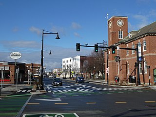
Davis Square is a major intersection in the northwestern section of Somerville, Massachusetts, United States, where several streets meet: Holland Street, Dover Street, Day Street, Elm Street, Highland Avenue, and College Avenue. The name is often used to refer to the West Somerville neighborhood surrounding the square as well.

Porter Square is a neighborhood in Cambridge and Somerville, Massachusetts, located around the intersection of Massachusetts Avenue and Somerville Avenue, between Harvard and Davis Squares. The Porter Square station serves both the MBTA Red Line and the Commuter Rail Fitchburg Line. A major part of the Lesley University campus is located within the Porter Square area.
Union Square is a neighborhood in the southeastern part of Somerville, Massachusetts, United States. It is centered on Union Square proper, which is located at the intersection of Washington Street, Webster Avenue, and Somerville Avenue.

Ball Square is a neighborhood primarily in Somerville, Massachusetts, United States, but also extending into Medford, at the intersection of Boston Avenue and Broadway, located between Powder House Square and Magoun Square. It is primarily a residential area with a handful of shops and restaurants along Broadway. Located on the edge of the neighborhood surrounding Tufts University, Ball Square contains a mix of businesses serving the student and academic populations as well as those reflecting the more blue-collar neighborhoods to the east.

Magoun Square is a neighborhood centered on the intersection of Broadway and Medford Streets on the border of Medford and Somerville, Massachusetts, United States. It is located between the neighborhoods of Ball Square and Winter Hill. It is a mixed-use urban business district, with commercial sites in the square and residential areas surrounding it. Trum Field, a park featuring baseball diamonds and basketball courts, is near Magoun Square, as is the headquarters of the Somerville Department of Public Works. Notable residents include playwright John Shea.

Winter Hill is a neighborhood in Somerville, Massachusetts, United States. It takes its name from the 120-foot hill that occupies its landscape, the name of which dates back to the 18th century. Winter Hill is located roughly north of Medford Street, west of McGrath Highway, and east of Magoun Square.
East Cambridge is a neighborhood of Cambridge, Massachusetts. East Cambridge is bounded by the Charles River and the Charlestown neighborhood of Boston on the east, the Somerville border on the north, Broadway and Main Street on the south, and the railroad tracks on the west. Most of the streets form a grid aligned with Cambridge Street, which was laid out to directly connect what is now the Charles River Dam Bridge with what in 1809 was the heart of Cambridge, Harvard Square. The northern part of the grid is a roughly six by eight block residential area. Cambridge Street itself is retail commercial, along with Monsignor O'Brien Highway, the Twin Cities Plaza strip mall, and the enclosed Cambridgeside Galleria. Lechmere Square is the transportation hub for the northern side. The southern half of the grid is largely office and laboratory space for hundreds of dot-com companies, research labs and startups associated with MIT, biotechnology firms including Genzyme, Biogen and Moderna, the Athenaeum Press Building, light industry, an NRG Energy power station, and various small businesses. This half of the neighborhood is generally identified with Kendall Square. Along the waterfront are several hotels and taller apartment buildings.
Queen Village is a residential neighborhood of Philadelphia, Pennsylvania, United States that lies along the eastern edge of the city in South Philadelphia. It shares boundaries with Society Hill to the north, Bella Vista to the west and Pennsport to the south. Street boundaries are the south side of Lombard Street to the north side of Washington Avenue, the Delaware River to 6th Street, encompassing two principal commercial corridors, South Street and Fabric Row on 4th Street.

West Newton is one of the thirteen villages within the city of Newton in Middlesex County, Massachusetts, United States.

South Medford is the southern neighborhood of Medford, Massachusetts.

Federal Hill is a neighborhood in Providence, Rhode Island. It lies immediately west of the city's Downtown, across Interstate 95. Since the late 19th century, Federal Hill has been an enclave of Providence's Italian American community; today the neighborhood is noted for its abundance of Italian restaurants, markets, and cultural establishments.

Powder House Square is a neighborhood and landmark rotary in Somerville, Massachusetts, United States. It is also known locally as Powder House Circle. It is the six-way intersection of College Avenue, Broadway, Warner Street, and Powder House Boulevard. Powder House Square stands at the southern tip of Tufts University's main Somerville/Medford campus, and borders the northern edge of Nathan Tufts Park. The square takes its name from the 18th century Powder House, which overlooks the rotary from Nathan Tufts Park.
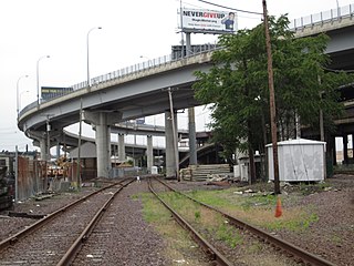
The Inner Belt District is a 126-acre (0.51 km2) industrial district located in the southeastern portion of Somerville, Massachusetts, United States. Along with nearby Brickbottom, the Inner Belt is a historically industrial zone of Somerville, with factories, warehouses, distribution centers, railroad connections, regional maintenance facilities, MBTA and Amtrak offices, retail stores and a hotel.
Mid-Cambridge, also known as "Area 6", is a neighborhood of Cambridge, Massachusetts. It is bounded by Massachusetts Avenue on the south and west, Prospect Street on the east, and Hampshire Street, the Somerville border, Kirkland Street, Quincy Street, and Cambridge Street on the north. The neighborhood borders Central Square, Harvard Square, and Inman Square.
North Cambridge, also known as "Area 11", is a neighborhood of Cambridge, Massachusetts bounded by Porter Square and the Fitchburg Line railroad tracks on the south, the city of Somerville on the northeast, Alewife Brook and the town of Arlington on the northwest, and the town of Belmont on the west. In 2005 it had a population of 10,642 residents living in 4,699 households, and the average income was $44,784. In 2010, the racial demographics for the neighborhood were 57.6% White, 20% Black, 15.1% Asian/Pacific Islander, 7.3% Hispanic origin, 0.3% Native American, 2.4% other race.

Ten Hills is a neighborhood in the northeastern part of the city of Somerville, Massachusetts. The area is roughly wedge-shaped, about 50 acres (200,000 m2) in size, and is bounded by the Mystic River to the north, McGrath Highway to the east, and is largely separated from the rest of Somerville by Interstate 93 to the southwest. Ten Hills is next to Assembly Square in the east, and Winter Hill in the southwest. The neighborhood landscape is predominated by a single hill, the peak of which is roughly at the intersection of Temple and Putnam Roads. The Ten Hills neighborhood is located in Ward 4, Precinct 1 of the City of Somerville, which is in the 34th district of Middlesex County.

East Somerville is a neighborhood in the eastern part of the city of Somerville, Massachusetts, United States. The community stretches east along Broadway, from Massachusetts Route 28 to Sullivan Square and Interstate 93 on the city line with the Boston neighborhood of Charlestown.

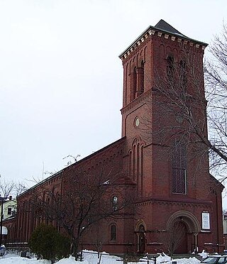
Gilman Square is a neighborhood in the area around Central Hill in Somerville, Massachusetts, United States. Historic Gilman Square is at the junction of Medford, Pearl, and Marshall streets and has been a small commercial center since the mid 19th-century. With the development of the Gilman Square Green Line station, city planning documents consider the area within a rough ten-minute walk of the new station to be part of the Gilman Square neighborhood.

