
The Eads Bridge is a combined road and railway bridge over the Mississippi River connecting the cities of St. Louis, Missouri, and East St. Louis, Illinois. It is located on the St. Louis riverfront between Laclede's Landing to the north, and the grounds of the Gateway Arch to the south. The bridge is named for its designer and builder, James Buchanan Eads. Work on the bridge began in 1867, and it was completed in 1874. The Eads Bridge was the first bridge across the Mississippi south of the Missouri River. Earlier bridges were located north of the Missouri, where the Mississippi is narrower. None of the earlier bridges survived, which means that the Eads Bridge is also the oldest bridge on the river.

The Chicago and North Western was a Class I railroad in the Midwestern United States. It was also known as the "North Western". The railroad operated more than 5,000 miles (8,000 km) of track at the turn of the 20th century, and over 12,000 miles (19,000 km) of track in seven states before retrenchment in the late 1970s. Until 1972, when the employees purchased the company, it was named the Chicago and North Western Railway.

The Michigan Central Railroad was originally chartered in 1832 to establish rail service between Detroit, Michigan, and St. Joseph, Michigan. The railroad later operated in the states of Michigan, Indiana, and Illinois in the United States and the province of Ontario in Canada. After about 1867 the railroad was controlled by the New York Central Railroad, which later became part of Penn Central and then Conrail. After the 1998 Conrail breakup, Norfolk Southern Railway now owns much of the former Michigan Central trackage.

The Porter Hollow Embankment and Culvert, also known as the Grand Rapids and Indiana Railroad Culvert, is a stone bridge and trestle over the Stegman Creek along the White Pine Trail in Algoma Township, Michigan.

The Illinois Central Stone Arch Railroad Bridges are a trio of limestone railroad bridges in the city of Dixon, Illinois, United States. The bridges were constructed between 1852 and 1855 as the Illinois Central Railroad laid its first rail lines across the state of Illinois. They were designed by Robert F. Laing for Laing and Douglas Construction Company, a railroad company contractor during the 1850s. Though each limestone bridge is similar in design, they each have different clearances ranging between 12 and 15 feet. The bridges remained in use by the railroad until 1985, and the three bridges were added to the U.S. National Register of Historic Places in 1987.
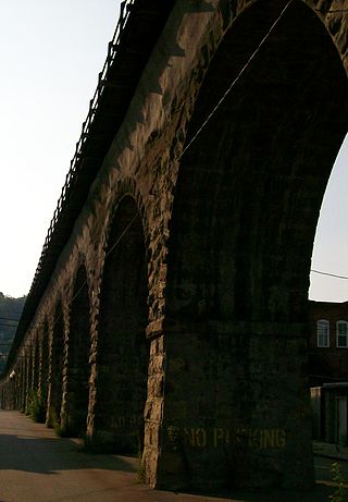
B & O Railroad Viaduct is a historic structure in Bellaire, Ohio, listed in the National Register of Historic Places on June 22, 1976.
The Galena and Southern Wisconsin Railroad Company was a railroad company in the United States. It constructed and operated a narrow gauge line between Galena, Illinois, and near Rewey, Wisconsin, via Platteville, Wisconsin. The railroad went through multiple reorganizations in the early 1880s before becoming part of the Chicago and North Western Railway system. The line was unified with that of the Chicago and Tomah Railroad and rebuilt as a 4 ft 8+1⁄2 in line. As the Platteville Subdivision of the Chicago and North Western, it was eventually abandoned in 1980.

The Soo Line High Bridge, also known as the Arcola High Bridge, is a steel deck arch bridge over the St. Croix River between Stillwater, Minnesota and Somerset, Wisconsin, United States. It was designed by structural engineer C.A.P. Turner and built by the American Bridge Company from 1910 to 1911. The bridge was listed on the National Register of Historic Places in 1977 for its national significance in the themes of engineering and transportation. It was nominated for its exceptional dimensions, beauty, innovative engineering techniques, and importance to transportation between Minnesota and Wisconsin.

The Chicago, Milwaukee, St. Paul and Pacific Railroad Company Historic District consists of the historic right-of-way of the Chicago, Milwaukee, St. Paul and Pacific Railroad in the Bitterroot Mountains from East Portal, Montana, to the mouth of Loop Creek, Idaho, a distance of 14.5 miles (23.3 km). The district was once part of the railroad's mainline from Chicago, Illinois to Tacoma, Washington.
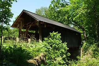
The Seguin Covered Bridge, also called the Upper Covered Bridge and the Sequin Covered Bridge, is a wooden covered bridge that crosses Lewis Creek in Charlotte, Vermont on Roscoe Road. It was built about 1850, and is a distinctive variant of a Burr arch design. It was listed on the National Register of Historic Places in 1974.

Church of St. Thomas the Apostle is a historic church at 822 E. Grand Avenue in Beloit, Wisconsin, United States. It was built in 1885 and was added to the National Register of Historic Places in 1983.

Valley Railroad Bridge or Gish Branch Bridge is a historic limestone arch bridge located over Gish Branch at Salem, Virginia. It was built in 1873 by the firm of Claiborne Rice (C.R.) Mason, under the local guidance of Thomas Menifee, engineer and employee of Mason. Mason was head of a syndicate hoping to link major railways of the north and south at Salem, Virginia - specifically by linking the Atlantic, Mississippi and Ohio Railroad with the Baltimore and Ohio Railroad, two of the major railways of the era.

The Stone Arch Bridge is a stone arch railroad bridge in Keene, New Hampshire, United States. Built in 1847 to carry the Cheshire Railroad, it is one of the best-preserved pre-1850 stone arch bridges in the nation. The bridge was listed on the National Register of Historic Places in 2012, and the New Hampshire State Register of Historic Places in 2006. It now carries a multi-purpose rail trail.

The Stone Arch Underpass is a historic stone arch bridge spanning Glen Road in Lebanon, New Hampshire. Built about 1848, it carried the Boston and Maine Railroad's former Northern Line. It is one of a small number of 19th-century stone arch bridges in the state, and the only one known in central western New Hampshire. The bridge was listed on the National Register of Historic Places in 1985. The railroad right-of-way has been functionally abandoned, and the bridge may become part of a continuation of the Northern Rail Trail.
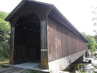
Wright's Bridge is a historic covered bridge in Newport, New Hampshire. Originally built in 1906 to carry the Boston and Maine Railroad across the Sugar River, it now carries the multi-use Sugar River Trail. The bridge was listed on the National Register of Historic Places in 1975.

Hunting Creek Railroad Bridge is a historic stone railroad bridge located at Morganton, Burke County, North Carolina. It was built about 1860, and is a two-span, stone arch bridge. It measures 130 feet long and stands about 24 feet above the creek. It was replaced by another bridge by at least 1890.
The Chicago, Rock Island and Pacific Railroad Stone Arch Viaduct, also known as the Old Stone Arch, is located northeast of Shelby, Iowa, United States. The span carried the Chicago, Rock Island and Pacific Railroad tracks over Little Silver Creek. It measures 35 feet (11 m) from the water level to the deck, 20 feet (6.1 m) in width, and 30 feet (9.1 m) in length. The bridge has flanking wingwalls that measure 40 feet (12 m) in length. Limestone for the bridge was quarried near Earlham, Iowa and transported by train to the site. It is one of two such bridges known to exist in Shelby County. The Rock Island was the first railroad to enter the county, and continued to operate here into the 1950s. At that time they abandoned the line when the Atlantic cutoff was built providing a more direct route between Atlantic, Iowa and Council Bluffs. While the tracks were removed, the stone arch, the railroad grade, and the right-of-way were left intact. They are now part of the Rock Island Old Stone Arch Nature Trail. The bridge was listed on the National Register of Historic Places in 1998.

The Hawkeye Street Underpass is a historic structure located south of Nora Springs, Iowa, United States. It spans South Hawkeye Street for 28 feet (8.5 m). The Illinois Central Railroad arrived in Nora Springs in 1868, and the Burlington, Cedar Rapids & Northern Railway (BCR&N) arrived three years later. The later was acquired by the Chicago, Rock Island & Pacific Railroad in the early 1880s. This stone masonry arch underpass was constructed by the Rock Island Line in 1889 as part of an upgrade of the tracks. It was designed by F.A. McDonald who had worked for the BCR&N. It is the only known stone arch bridge in Floyd County. The bridge was listed on the National Register of Historic Places in 1998.

The West Sixth Street Bridge is a historic stone arch bridge in downtown Austin, Texas. Built in 1887, the bridge is one of the state's oldest masonry arch bridges. It is located at the site of the first bridge in Austin, carrying Sixth Street across Shoal Creek to link the western and central parts of the old city. The bridge was added to the National Register of Historic Places in 2014.

