
Lake of the Ozarks State Park is a Missouri state park on the Grand Glaize Arm of the Lake of the Ozarks and is the largest state park in the state. This is also the most popular state park in Missouri, with over 2.5 million visitations in 2017.
The Big Buffalo Valley Historic District, also known as the Boxley Valley Historic District, is notable as a cultural landscape in Buffalo National River. It comprises the Boxley Valley in northern Arkansas, near the town of Ponca. The valley includes a number of family-operated farms, primarily dating between 1870 and 1930. The farms are situated on either side of the road that parallels the river, Highway 43. Many of these farms are still operated by the descendants of the original homesteaders. However, of fifty residences in the valley, thirty were vacant in 1987, at the time of historic designation.
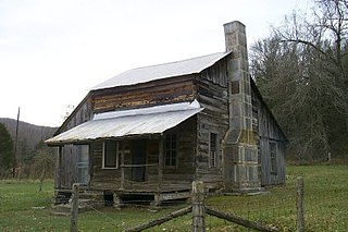
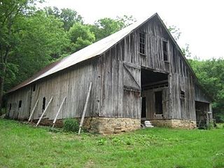
The Parker–Hickman Farm includes the oldest standing log structure in Buffalo National River. The farm was homesteaded in the 1840s by settlers from Tennessee. It embodies an agricultural landscape with farmstead, extant fields, fencerows, roads, cattle gates, garden and orchard plots, wooded slopes and springs. Unlike most farms in the Ozarks the landscape is remarkably intact and provides insights and evidence spanning portions of two centuries of Ozark history; not randomly chosen, it conveys a feeling of enclosure and exemplifies adaptive use of topography. Among farms of its kind in Missouri and Arkansas it was once typical but now survives as a rare baseline example for Ozark yeomanry farms of mixed economies. Parker–Hickman was an agricultural enterprise that continuously operated until 1982 from a farmstead which exemplifies the entire period, and a rare one for the Ozarks since it survives. Clustered around the farmstead are several structures: barns, sheds smokehouse, privy, fences, stock feeders and house that represent a cross-section of rural vernacular architecture still in their original location.

Jacob Leiby Farm is a historic farm complex, Pennsylvania Bluestone quarry, and national historic district located in Perry Township, Berks County, Pennsylvania. It has six contributing buildings, two contributing sites, and three contributing structures. All of the buildings are constructed of Pennsylvania Bluestone. They include a 2 1/2-story, five-bay by two-bay, vernacular Federal-style farmhouse (1829); 1 1/2-story, tenant house/blacksmith shop; Pennsylvania bank barn; wagon shed; cider house; and quarry house. The contributing structures are a bake oven, ground cellar, and large stone and earthen dam on Maiden Creek. The contributing sites are the Pennsylvania Bluestone quarry and cemetery. The quarry ceased operation in 1884, with the death of Jacob Leiby.

John Williams Farm, also known as the Davis B. Williams Farm and Stinson Markley Residence, is a historic farm complex and national historic district located in Charlestown Township, Chester County, Pennsylvania. It includes five contributing buildings and one contributing site. They are the farmhouse, bank barn (1834), garden and springhouse, and wagon house, and the remains of the "necessary" and animal pen.

Deery Family Homestead is a historic farm and national historic district located in West Vincent Township, Chester County, Pennsylvania. The district includes 10 contributing buildings on a self-sustaining family compound. The buildings include the following on the Main Farm: the main house, large stone and frame bank barn (1819), and stone and frame wagon shed. On the Henry Derry Farm are the main house, smaller house, root cellar, large stone bank barn, and two small stone buildings. The district also includes the George Deery House and Tenant House.

Burrland Farm Historic District is a historic home and farm complex and national historic district located near Middleburg, Fauquier County, Virginia. The district encompasses 22 contributing buildings, 2 contributing sites, 14 contributing structures, and 1 contributing object on a 458-acre thoroughbred horse breeding and training farm. The buildings were built between 1927 and 1932, and include a Georgian Revival style training barn, a polo barn, a stallion barn, two broodmare barns, a yearling barn, a field shed, an equipment shed, a farm manager's house / office, a trainer's cottage, a mess hall quarters, a foreman's dwelling, three mash houses, five garages, a pumphouse, and a feed and storage warehouse. The contributing structures include a silo, a springhouse, three loading chutes, two teasing chutes, two rings, three run-in sheds, one sun hut and an entrance gate. The original Burrland house was built in 1879, expanded in 1927 by architect William Lawrence Bottomley, and burned down in 1961.

Charles F. and Howard Cates Farm, also known as Swathmoor Farm, is a historic farm complex and national historic district located near Mebane, Alamance County, North Carolina. It encompasses 11 contributing buildings, 1 contributing site, and 5 contributing structures on a farm near Mebane. The district includes the two-story double-pile Cates farmhouse and a collection of outbuildings and supporting structures. These include outbuildings probably associated with pickle manufacture such as the packhouse and the office (c. 1920); outbuildings associated with dairying including the multipurpose barn, the well house, and the milk barn ; and the mule barn, gas house, tool shed, pump house, privy, and chicken house. Its owner Charles F. Cates was instrumental in establishing the Woodlawn School.
A.S. Cooper Farm is a historic farm complex and national historic district located near Brownwood, Ashe County, North Carolina. The district encompasses 13 contributing buildings, 2 contributing sites, and 1 contributing structure. They are located in three primary clusters on the farm. The A.S. Cooper, Sr. cluster includes the A.S. Cooper, Sr. House, spring house, tool shed / wood shed, chicken coop, granary, and garage (1934). The second cluster is the barn / milking parlor, and silo complex. The third cluster includes the Albert Sidney Cooper, Jr. House (1918), small shed, kitchen building, shed, spring house, and barn. Associated with the complex is the family cemetery and agricultural landscape.
McLeod Family Rural Complex is a historic farm and national historic district located near Pine Bluff, Moore County, North Carolina. The district encompasses 10 contributing buildings, 1 contributing site, and 3 contributing structures on a family farm established in the mid-19th century. It includes two houses: the John McLeod House is a largely intact, 1 1/2-story, frame dogtrot plan house dated to about 1840. The Alex McLeod House was built in 1884, and is a two-story, five bay, traditional frame farmhouse. Other contributing resources include two tobacco barns, a pack house, fertilizer house, barn with stables, corn crib, saddle-notched log house, chicken house, shed, root cellar, and smokehouse.
Venters Farm Historic District is a historic farm complex and national historic district located near Richlands, Onslow County, North Carolina. The complex includes 23 contributing buildings. The main house was built about 1896, and is two-story frame, late Victorian farm house with a detached kitchen. Other contributing buildings include a corn barn, a carriage house, a smokehouse, mule / hay barn, cow / pig barn, eight tobacco barns, a brooder house, and seven tenant houses.

Watkins Family Farm Historic District, also known as Lakeland Farm, is a historic home and farm and national historic district located near Raymore, Cass County, Missouri. The farm includes 18 contributing buildings, three contributing sites, and 21 contributing structures dated between about 1868 and 1957. They include three residential buildings, eight barns, three machine and implement sheds, four wells, ten dams and ponds, and a number of ancillary structures such as a milk house, a pump house, an outhouse, a silo, two corn bins, two chicken coops, three cattle feeder structures, and a cattle loading ramp. The Allen-Watkins Residence was built in 1913, and is a 2 1/2-story, Prairie School style frame dwelling built from the Sears and Roebuck Company prefabricated kit for Sears House Plan #227, "The Castleton."

Dulle Farmstead Historic District, also known as Pleasant Home Farm, is a historic home and farm and national historic district located near Jefferson City, Cole County, Missouri. It encompasses nine contributing buildings and one contributing structure and include the brick I-house form farmhouse (1902), the multi-purpose barn, the cattle barn (1933), the ice house, the garage (1942), two chicken shelters, two brooder houses, and an oak plank and iron beam bridge (1934).

Nichols Farm District, also known as the Susie Nichols Cabin site, is a historic farm and national historic district located near Cedar Grove, Dent County, Missouri. The district encompasses a house, barn, corn crib, associated landscape features, and refuse dump. It is representative of a late-19th and early-20th century Ozark farmstead.
John A. Adams Farmstead Historic District, also known as Cedarcroft Farm, is a historic home and farm and national historic district located near Warrensburg, Johnson County, Missouri. The district consists of four contributing properties --three contributing buildings and one contributing structure. The buildings are a house, a barn, and a barn. The structure is a system of sewer and drainage tiles and dams constructed beginning in 1875 and which underlays much of the district.
Ephraim J. Wilson Farm Complex is a historic home and farm located near Palmyra, Marion County, Missouri. The house was built about 1842, and is a two-story, Federal style brick I-house with a rear frame addition built around 1889. Also on the property are the contributing timber frame bank barn built by a Mennonite of Pennsylvania German extraction in 1888, and an ice house. It was added to the National Register of Historic Places in 1982.
The Osage Farms Resettlement Properties in Pettis County, Missouri is a National Register of Historic Places multiple property submission located at Pettis County, Missouri. The submission includes 10 national historic districts and 2 individual properties listed on the National Register of Historic Places. The properties included were built by the Resettlement Administration / Farm Security Administration in 1937 as model farms and known as Osage Farms. Model farmsteads typically included a 1 1/2-story frame dwelling, barn, poultry house and privy.
Isiah Mansur Farmstead Historic District, also known as Rock Hall, is a historic home and farm and national historic district located near Richmond, Ray County, Missouri. The district encompasses eight contributing buildings, one contributing site, and three contributing structures on a farm developed between the mid-19th and mid-20th centuries. The contributing resources include the main farmhouse, a buggy house, a large barn, an engine house (c.1900), a small barn, a brooder house, a hen house, a smokehouse, a house well, a field well, and a wellhouse. The main farmhouse is a two-story, five bay, frame I-house.

Walter Klepzig Mill and Farm is a historic farm and sawmill and national historic district located in the Ozark National Scenic Riverways near Eminence, Shannon County, Missouri. The district encompasses three contributing buildings, three contributing sites, and one contributing structure associated with an early-20th century Ozark farm and mill. It developed between about 1912 and 1936 and includes the mill and its related hydraulic system ; a spring house and smokehouse ; foundations of a 1923 farmhouse and barn ; and two post-1934 chicken coops and a ruin of a post-1934 machine shed.
Prairie View Stock Farm, also known as the Bluestem Ranch, is a historic farm and national historic district located near Rich Hill in Bates County and Vernon County, Missouri. The district encompasses four contributing buildings, three contributing sites, and two contributing structures in a Rural Historic Landscape District. The contributing sites include a hay meadow, a tall fescue prairie, and a 160-acre plot of native, tall-grass prairie. It is a state designated Prairie View Natural Area. The contributing buildings are a transverse-crib barn/grain house, a barn/feeding facility, a two-story, frame, folk Victorian house (1893-1894), and a frame privy (1893-1894). The contributing structures are a storm cellar (1893-1894) and an arbor.


