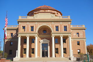
Atascadero is a city in San Luis Obispo County, California, about equidistant from Los Angeles and San Francisco on U.S. Route 101. Atascadero is part of the San Luis Obispo-Paso Robles metropolitan statistical area, which encompasses the extents of the county. Atascadero is farther inland than most other cities in the county, and as a result, usually experiences warmer, drier summers, and cooler winters than other nearby cities such as San Luis Obispo and Pismo Beach. The main freeway through town is the US 101. The nearby State Routes 41 and 46 provide access to the Pacific Coast and the California Central Valley.

San Luis Obispo for short, is a city in the U.S. state of California, located 190 miles (310 km) north of Los Angeles in Southern California's Central Coast region. The population was 45,119 at the 2010 census. The population of San Luis Obispo County was 269,637 in 2010.

Lake Nacimiento is an 18-mile (29 km) long lake on the Nacimiento River in northern San Luis Obispo County, California. The lake contains many arms including Snake Creek and Dip Creek, nearer the dam, and the central Las Tablas and Franklin Creeks. Because of the dragon-like shape created by the positions of these arms, it is sometimes referred to as Dragon Lake. The lake can fill quickly in the winter from river surges resulting from downpours upstream in the Santa Lucia Range so the level is not usually allowed to capacity until May 1 of each year.

The Carrizo Plain (Obispeño: tšɨłkukunɨtš, "Place of the rabbits"; is a large enclosed grassland plain, approximately 50 miles long and up to 15 miles across, in southeastern San Luis Obispo County, California, about 100 miles northwest of Los Angeles. It contains the 246,812-acre Carrizo Plain National Monument, and it is the largest single native grassland remaining in California. It includes Painted Rock in the Carrizo Plain Rock Art Discontiguous District, which is listed on the National Register of Historic Places. In 2012 it was further designated a National Historic Landmark due to its archeological value. The San Andreas Fault cuts across the plain.

The San Luis Obispo Botanical Garden is a botanical garden located in the rolling hills of El Chorro Regional Park, between San Luis Obispo and Morro Bay in San Luis Obispo County, within the Central Coast of California region. Its grounds, when completed, will be a 150-acre (61 ha) collection of gardens displaying the diverse plant life of the five Mediterranean climate zones of the world; the Mediterranean Basin, and regions of California, Chile, Australia, and South Africa.
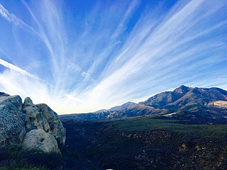
Los Padres National Forest is a United States national forest in southern and central California. Administered by the United States Forest Service, Los Padres includes most of the mountainous land along the California coast from Ventura to Monterey, extending inland. Elevations range from sea level to 8,847 feet (2,697 m).

Los Osos is an unincorporated community and a census-designated place located along the Pacific coast of San Luis Obispo County, California. The community is part of the 93402 and 93412 ZIP codes and area code 805. The population was 14,276 at the 2010 census.

Guadalupe-Nipomo Dunes is the largest remaining dune system south of San Francisco and the second largest in the U.S. state of California. It encompasses an 18-mile (29 km) stretch of coastline on the Central Coast of California and extends from southern San Luis Obispo County to northern Santa Barbara County.

Anthony Chabot Regional Park is a regional park in Oakland, Alameda County, California in the United States. It is part of the East Bay Regional Park District system, and covers 5,067 acres (2,051 ha) in the San Leandro Hills adjacent to Oakland, San Leandro and Castro Valley. Popular activities include hiking, cycling and horseback riding. A gun range operated by the Chabot Gun Club was shut down in 2016, following complaints about pollution.

The San Luis Reservoir is an artificial lake on San Luis Creek in the eastern slopes of the Diablo Range of Merced County, California, approximately 12 mi (19 km) west of Los Banos on State Route 152, which crosses Pacheco Pass and runs along its north shore. It is the fifth largest reservoir in California. The reservoir stores water taken from the San Joaquin-Sacramento River Delta. Water is pumped uphill into the reservoir from the O'Neill Forebay which is fed by the California Aqueduct and is released back into the forebay to continue downstream along the aqueduct as needed for farm irrigation and other uses. Depending on water levels, the reservoir is approximately nine miles long from north to south at its longest point, and five miles (8 km) wide. At the eastern end of the reservoir is the San Luis Dam, or the B.F. Sisk Dam, the fourth largest embankment dam in the United States, which allows for a total capacity of 2,041,000 acre feet (2,518,000 dam3).

Lake San Antonio is a lake located primarily in southern Monterey County, California, and partially in northern San Luis Obispo County, California. The lake is formed by San Antonio Dam on the San Antonio River. The dam is 202 feet tall and was completed in 1965 under Monterey County District Engineer Loran Bunte Jr. The lake and dam are owned by the Monterey County Water Authority. The lake has a capacity of 350,000 acre feet (430,000,000 m3).
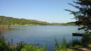
Santa Margarita Lake, also called Salinas Reservoir, is a lake several miles southeast of the town of Santa Margarita in San Luis Obispo County, California. The lake was created by the building of Salinas Dam on the southern end of the Salinas River, very close to the river's origin in the Santa Lucia Range.

Camp San Luis Obispo is the original home of the California Army National Guard. It served as an Infantry Division Camp and Cantonment Area for the United States Army during World War II.

Dwarf forest, elfin forest, or pygmy forest is an uncommon ecosystem featuring miniature trees, inhabited by small species of fauna such as rodents and lizards. They are usually located at high elevations, under conditions of sufficient air humidity but poor soil. There are two main dwarf forest ecosystem types, involving different species and environmental characteristics: coastal temperate and montane tropical regions. Temperate coastal dwarf forest is common for parts of Southern California. Montane tropical forests are found across tropical highlands of Central America, northern South America and Southeast Asia. There are also other isolated examples of dwarf forests scattered across the world, while the largest dwarf forest is found in the Philippines.

Rancho San Antonio County Park and Rancho San Antonio Open Space Preserve are a conjoined public recreational area in the Santa Cruz Mountains, in the northwest quadrant of Santa Clara County, California. The County Park is bordered by Los Altos with some parts of the eastern part of the County Park in western Cupertino. The Open Space Preserve is on the west side of the County Park, also bordered by Los Altos Hills, Monte Bello Open Space Preserve, and the Permanente Quarry.
Ponderosa Campground is a United States Forest Service campground in the high country of Big Sur, on the central coast of California in the Los Padres National Forest. The campground has 21 sites set in a high valley adjacent to the Nacimiento River, featuring a canopy of Ponderosa Pine, Oak, Madrone, and California Sycamore trees. Each site includes a picnic table, fire ring, and pedestal grill. The campground is on the Nacimiento-Fergusson Road.

Hearst San Simeon State Park is a state park of California, USA, preserving rocky coast and rare habitats. It is located between Cambria and San Simeon. The 3,409-acre (1,380 ha) park was first established in 1932. The park includes the Santa Rosa Creek Natural Preserve, the San Simeon Natural Preserve and the Pa-nu Cultural Preserve, which were established in 1990.
Los Osos Oaks State Natural Reserve is a California State Park in western San Luis Obispo County, in the Central Coast of California region. It preserves centuries-old coast live oaks growing atop relict sand dunes. It is located in the Los Osos Valley between San Luis Obispo and Baywood Park-Los Osos, just outside the town of Los Osos. The 85-acre (34 ha) park was established in 1972.
Rancho El Chorro was a 3,167-acre (12.82 km2) Mexican land grant in present day San Luis Obispo County, California given in 1845 by Governor Pío Pico to business partners James (Diego) Scott and John (Juan) Wilson. The grant between Morro Bay and San Luis Obispo extended along the north bank of Chorro Creek.
Rancho Huerta de Romualdo was a 117-acre (0.47 km2) Mexican land grant in present day San Luis Obispo County, California given in 1842 by Governor Juan B. Alvarado and in 1846 by Governor Pío Pico to Romualdo. The name means Romualdo's vegetable garden. The grant between Morro Bay and San Luis Obispo, extended along Chorro Creek and encompassed Cerro Romauldo.

