Churchville, Pennsylvania

Last updated

Churchville
Churchville Station.JPG
Former Churchville train station and Post Office. For a time the postmaster lived above the station.
USA Pennsylvania location map.svg
Red pog.svg
Churchville
Location of Churchville in Pennsylvania
Coordinates: 40°12′03″N74°59′49″W / 40.20083°N 74.99694°W / 40.20083; -74.99694
CountryUnited States
StatePennsylvania
County Bucks
Township Northampton
Area
[1]
  Total3.48 sq mi (9.00 km2)
  Land3.20 sq mi (8.30 km2)
  Water0.27 sq mi (0.71 km2)
Elevation
203 ft (62 m)
Population
 (2020) [2]
  Total5,348
  Density1,669.16/sq mi (644.51/km2)
Time zone UTC-5 (EST)
  Summer (DST) UTC-4 (EDT)
Area code(s) 215, 267 and 445
FIPS code 42-13648

Churchville is a census-designated place (CDP) in Northampton Township, Bucks County, Pennsylvania, United States. The population was 4,128 at the 2010 census. [3]

Contents

Geography

According to the U.S. Census Bureau, Churchville has a total area of 2.0 square miles (5.2 km2), of which 0.04 square miles (0.10 km2), or 0.98%, is water.

Demographics

Historical population
CensusPop.Note
1990 4,255
2000 4,4695.0%
2010 4,128−7.6%
2020 5,34829.6%
[4] [5] [2]

As of the 2010 census, Churchville was 95.3% White, 0.5% Black or African American, 2.1% Asian, and 0.8% were two or more races. 1.2% of the population was of Hispanic or Latino ancestry. [6]

As of the census [7] of 2000, there were 4,469 people, 1,370 households, and 1,257 families residing in the CDP. The population density was 2,215.2 inhabitants per square mile (855.3/km2). There were 1,375 housing units at an average density of 681.6 per square mile (263.2/km2). The racial makeup of the CDP was 97.99% White, 0.40% African American, 1.19% Asian, 0.04% from other races, and 0.38% from two or more races. Hispanic or Latino of any race were 0.51% of the population.

There were 1,370 households, out of which 42.8% had children under the age of 18 living with them, 85.9% were married couples living together, 4.3% had a female householder with no husband present, and 8.2% were non-families. 7.2% of all households were made up of individuals, and 3.1% had someone living alone who was 65 years of age or older. The average household size was 3.20 and the average family size was 3.35.

In the CDP, the population was spread out, with 26.2% under the age of 18, 7.7% from 18 to 24, 23.9% from 25 to 44, 32.0% from 45 to 64, and 10.3% who were 65 years of age or older. The median age was 41 years. For every 100 females, there were 95.4 males. For every 100 females age 18 and over, there were 91.9 males.

The median income for a household in the CDP was $95,010, and the median income for a family was $97,114. Males had a median income of $65,550 versus $41,750 for females. The per capita income for the CDP was $32,507. About 1.5% of families and 2.6% of the population were below the poverty line, including 2.1% of those under age 18 and 7.9% of those age 65 or over.

Passenger trains

History

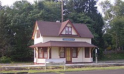
Churchville's population boom and growth as a commuter haven took place in the mid-1980s, just after the town lost its commuter railway line. Trains served the town until January 14, 1983 [8] via SEPTA's Fox Chase-Newtown Rapid Transit Line. The station, and all of those north of Fox Chase, were closed due to failing diesel train equipment that the then-cash-strapped SEPTA could not afford to rehabilitate. As a result, ridership was low and the service cancelled on a "temporary" basis. As such, Churchville Station still appears in SEPTA's publicly posted tariffs. [9]

Although rail service was initially replaced with a Fox Chase-Newtown shuttle bus, patronage remained light. The traveling public never saw a bus service as a suitable replacement for a rail service, and the Fox Chase-Newtown shuttle bus service ended in 1999.

The Churchville Historic District was added to the National Register of Historic Places in 1995. [10]

Resumption of passenger train service

In the ensuing years since 1983, there has been heavy interest by both residents and politicians in resuming passenger service to Churchville.

In September 2009, the Southampton-based Pennsylvania Transit Expansion Coalition (PA-TEC) began discussions with township officials along the railway, as well as SEPTA officials, about the realistic possibility of resuming even minimal passenger service to relieve traffic congestion in the region. Plans call for completing the electrification to Newtown, as originally planned in the late 1970s.

PA-TEC's efforts have received overwhelming bipartisan support by both Bucks and Montgomery County officials, as well as at the state level, despite SEPTA's overall reservations. [11] However, SEPTA has also confirmed they are willing to reestablish regular commuter service if strong political support exists in both counties. [12]

Sights

The Churchville Nature Center, operated by the facility of the Bucks County Department of Parks and Recreation, protects 65 acres of wildlife preserve. The center features a visitor center with exhibits, a reptile room, a recreated 1500s Lenape village, a seasonal native butterfly house, gardens and 2 miles of trails. [13]

Notable person

Related Research Articles

<span class="mw-page-title-main">Channel Lake, Illinois</span> Census-designated place in Illinois, United States

Channel Lake is an unincorporated community and census-designated place (CDP) in Antioch Township, Lake County, Illinois, United States. Per the 2020 census, the population was 1,581.

Fox Lake Hills is an unincorporated community and census-designated place (CDP) in Lake Villa Township, Lake County, Illinois, United States. Per the 2020 census, the population was 2,684.

Long Lake is an unincorporated community and census-designated place (CDP) in Lake County, Illinois, United States. Per the 2020 census, the population was 3,663.

<span class="mw-page-title-main">Imperial, Missouri</span> Census-designated place in Missouri, United States

Imperial is a census-designated place (CDP) in Jefferson County, Missouri, United States, and is a suburb of St. Louis. The population was 4,947 at the 2020 census. Imperial was originally known as West Kimmswick, the historic Catholic church of St. John’s in Imperial, became an independent parish in 1869.

<span class="mw-page-title-main">Pine Ridge at Crestwood, New Jersey</span> Populated place in Ocean County, New Jersey, US

Pine Ridge at Crestwood is an unincorporated community and census-designated place (CDP) located within Manchester Township, in Ocean County, in the U.S. state of New Jersey. As of the 2010 United States Census, the CDP's population was 2,369.

Brittany Farms-The Highlands is a census-designated place (CDP) in Bucks County, Pennsylvania, United States. The population was 3,695 at the 2010 census. At the 2000 census, it was listed as "Brittany Farms-Highlands" CDP.

<span class="mw-page-title-main">Newtown, Bucks County, Pennsylvania</span> Borough in Pennsylvania, United States

Newtown is a borough in Bucks County, Pennsylvania, United States. The population was 2,268 at the 2020 census. It is located just west of the Trenton, New Jersey metropolitan area, and is part of the larger Philadelphia metropolitan area. It is entirely surrounded by Newtown Township, from which it separated in 1838. State Street is the main commercial thoroughfare with wide sidewalks, shops, taverns, and restaurants.

<span class="mw-page-title-main">Newtown Grant, Pennsylvania</span> Census-designated place in Pennsylvania, United States

Newtown Grant is a census-designated place (CDP) in Bucks County, Pennsylvania, United States. The population was 3,620 at the 2010 census.

<span class="mw-page-title-main">Northampton Township, Bucks County, Pennsylvania</span> Township in Pennsylvania, United States

Northampton Township is a township in Bucks County, Pennsylvania, United States. The township is located approximately 12 miles northeast of Philadelphia. The population was 39,726 at the 2010 census.

<span class="mw-page-title-main">Richboro, Pennsylvania</span> Census-designated place in Pennsylvania, United States

Richboro is a census-designated place (CDP) in Northampton Township, Bucks County, Pennsylvania, United States. The population was 6,378 during the 2020 census.

<span class="mw-page-title-main">Upper Southampton Township, Bucks County, Pennsylvania</span> Township in Pennsylvania, United States

Upper Southampton Township is a township in Bucks County, Pennsylvania, United States. The population was 15,152 at the 2010 census.

<span class="mw-page-title-main">Warminster Heights, Pennsylvania</span> Census-designated place in Pennsylvania, United States

Warminster Heights is a census-designated place and part of Warminster Township in Bucks County, Pennsylvania, United States. It is located near the eastern border of Hatboro in Montgomery County. The population was 4,124 at the 2010 census.

<span class="mw-page-title-main">Woodbourne, Pennsylvania</span> Census-designated place in Pennsylvania, United States

Woodbourne is a census-designated place (CDP) in Bucks County, Pennsylvania, United States. The population was 3,851 at the 2010 census.

<span class="mw-page-title-main">Woodside, Pennsylvania</span> Census-designated place in Pennsylvania, United States

Woodside is a census-designated place (CDP) in Bucks County, Pennsylvania, United States. The population was 2,425 at the 2010 census.

<span class="mw-page-title-main">Thorndale, Pennsylvania</span> Census-designated place in Pennsylvania, United States

Thorndale is a census-designated place in Chester County, Pennsylvania, United States. The population was 3,407 at the 2010 census. Thorndale is the commercial and administrative center of Caln Township. The community's main street is U.S. Route 30 Business. Many of Thorndale's old houses fell into disrepair from the late 1990s to present and have been torn down and replaced with new businesses. Thorndale is historically notable for containing a summer house of US President James Buchanan, which still stands and has been incorporated into a golf course and turned into a restaurant. The community contains the Thorndale Fire Station and Caln Elementary School, part of the Coatesville Area School District. Thorndale sits along SEPTA's Paoli/Thorndale Line and is currently the last station stop on that line. It is also served by the SEPTA Route 135 bus.

<span class="mw-page-title-main">Bryn Athyn, Pennsylvania</span> Home Rule Municipality in Pennsylvania, United States

Bryn Athyn is a home rule municipality in Montgomery County, Pennsylvania. It was formerly a borough, and its official name remains "Borough of Bryn Athyn". The population was 1,375 at the 2010 census. It was formed for religious reasons from Moreland Township on February 8, 1916. Bryn Athyn is surrounded by Lower Moreland Township.

<span class="mw-page-title-main">Montgomeryville, Pennsylvania</span> Census-designated place in Pennsylvania, United States

Montgomeryville is a census-designated place (CDP) in Montgomery Township, Montgomery County, Pennsylvania, United States. The population was 12,624 at the 2010 census. According to a 2010 Forbes magazine/Yahoo.com survey, Montgomeryville ranks 5th in America's top 10 affordable suburbs. It is part of the North Penn Valley region that is centered on the borough of Lansdale.

<span class="mw-page-title-main">Rockledge, Pennsylvania</span> Borough in Pennsylvania, United States

Rockledge is a borough in Montgomery County, Pennsylvania, United States. The population was 2,638 as of the 2020 census. Rockledge is surrounded by Abington Township and the city of Philadelphia, and shares a ZIP code with Jenkintown.

<span class="mw-page-title-main">Hillandale, Maryland</span> Census-designated place in Maryland, United States

Hillandale is an unincorporated area and census-designated place located in Montgomery and Prince George's counties, Maryland, United States. As of the 2020 census, it had a population of 5,774. Hillandale is contained between the Prince George's / Montgomery County line to the east, the Anacostia River to the west, McCeney Avenue to the north, and D.C.'s Capital Beltway to the south. It borders the communities of Adelphi, Avenel, White Oak and Beltsville.

<span class="mw-page-title-main">Yarmouth (CDP), Maine</span> Census-designated place in Maine, United States

Yarmouth is a census-designated place (CDP) in the town of Yarmouth in Cumberland County, Maine, United States. The population was 6,125 at the 2020 census. It is part of the Portland–South Portland–Biddeford, Maine Metropolitan Statistical Area.

References

  1. "ArcGIS REST Services Directory". United States Census Bureau. Retrieved October 12, 2022.
  2. 1 2 "Census Population API". United States Census Bureau. Retrieved October 12, 2022.
  3. "Race, Hispanic or Latino, Age, and Housing Occupancy: 2010 Census Redistricting Data (Public Law 94-171) Summary File (QT-PL), Churchville CDP, Pennsylvania". United States Census Bureau . Retrieved August 11, 2011.
  4. "DVRPC > Site Search". Archived from the original on April 9, 2019. Retrieved January 31, 2017.
  5. "Census 2020".
  6. "U.S. Census website". United States Census Bureau . Retrieved January 31, 2008.
  7. r8newtown.com Archived 2010-05-24 at the Wayback Machine . r8newtown.com. Retrieved on 2011-11-03.
  8. SEPTA Tariff No. 154; effective July 1, 2009 Archived 2012-05-31 at the Wayback Machine . (PDF) . Retrieved on 2011-11-03.
  9. "National Register Information System". National Register of Historic Places . National Park Service. July 9, 2010.
  10. Werner, Jeff (March 5, 2010). "SEPTA: Reactivation of Newtown rail line a difficult prospect". Bucks Local News.
  11. r8newtown.com. r8newtown.com. Retrieved on 2011-11-03.
  12. "Welcome". Churchville Nature Center. Retrieved November 20, 2020.