Related Research Articles

Arrowsic is a town in Sagadahoc County, Maine, United States. The population is 501 as of 2014. It is part of the Portland–South Portland–Biddeford, Maine metropolitan statistical area. During the French and Indian Wars, Arrowsic was site of a succession of important and embattled colonial settlements. It is a favorite with artists and birdwatchers.
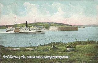
Phippsburg is a town in Sagadahoc County, Maine, United States, on the west side of the mouth of the Kennebec River. The population was 2,216 at the 2010 census. It is within the Portland–South Portland–Biddeford, Maine, metropolitan statistical area. A tourist destination, Phippsburg is home to Bates-Morse Mountain Conservation Area, Fort Popham State Historic Site; it is also home to Fort Baldwin which overlooks Fort Popham, and Popham Beach State Park, as well as Pond Island National Wildlife Refuge. The town includes part of Winnegance.

King William's War was the North American theater of the Nine Years' War (1688–1697), also known as the War of the Grand Alliance or the War of the League of Augsburg. It was the first of six colonial wars fought between New France and New England along with their respective Native allies before France ceded its remaining mainland territories in North America east of the Mississippi River in 1763.
King Philip's War was an armed conflict in 1675–1678 between indigenous inhabitants of New England and New England colonists and their indigenous allies. The war is named for Metacom, the Wampanoag chief who adopted the name Philip because of the friendly relations between his father Massasoit and the Mayflower Pilgrims. The war continued in the most northern reaches of New England until the signing of the Treaty of Casco Bay in April 1678.

Port-Royal National Historic Site is a National Historic Site located on the north bank of the Annapolis Basin in the community of Port Royal, Nova Scotia. The site is the location of the Habitation at Port-Royal.

Beaubassin was an important Acadian village and trading centre on the Isthmus of Chignecto in what is now Nova Scotia, Canada. The area was a significant place in the geopolitical struggle between the British and French empires. It was established in the 1670s on an upland close to an extensive area of saltwater marsh. Settlers reclaimed the land to engage in cattle ranching and trade.

Norridgewock was the name of both an Indian village and a band of the Abenaki Native Americans/First Nations, an Eastern Algonquian tribe of the United States and Canada. The French of New France called the village Kennebec. The tribe occupied an area in the interior of Maine. During colonial times, this area was territory disputed between British and French colonists, and was set along the claimed western border of Acadia, the western bank of the Kennebec River.
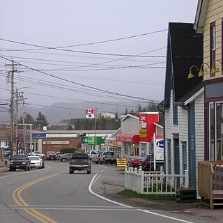
St. Peter's is a small incorporated village located on Cape Breton Island in Richmond County, Nova Scotia, Canada.

The Charlesfort-Santa Elena Site is an important early colonial archaeological site on Parris Island, South Carolina. It contains the archaeological remains of a French settlement called Charlesfort, settled in 1562 and abandoned the following year, and the later 16th-century Spanish settlement known as Santa Elena. The Spanish remains include a fort built directly on top of the abandoned Charlesfort remains. This fort and other nearby structures have been called, at various times, Fort San Marcos, Fort San Felipe, and have the designated archaeological site identifiers 38BU51 and 38BU162. Because of their remarkable state of preservation, and their importance in understanding early French and Spanish colonial practices, the site was designated a National Historic Landmark in 2001. The site is accessible through the United States Marine Corps Recruit Depot in Port Royal, South Carolina.

Colonial Pemaquid State Historic Site is a publicly owned historic property operated by the state of Maine near Pemaquid Beach in Bristol, Maine. The site includes the reconstructed Fort William Henry, archaeological remains of 17th- and 18th-century village buildings and fortifications, and a museum with artifacts found on the site including musket balls, coins, pottery, and early hardware.
Damariscove is an uninhabited island that is part of Boothbay Harbor, Lincoln County, Maine, United States, about 5 nautical miles (9.3 km) off the coast at the mouth of the Damariscotta River. The long, narrow island is approximately 2 miles (3.2 km) long and 1,500 feet (460 m) at its widest point. The island has served in the past as a fishing settlement and a Coast Guard life saving station.

The Sommerheim Park Archaeological District includes a group of six archaeological sites west of Erie, Pennsylvania in the United States. The sites are in Sommerheim Park, one of the few undeveloped areas of the Lake Erie shoreline, in Millcreek Township. This district has been listed on the National Register of Historic Places. This is one of the leading archaeological sites in the Erie area and along the southern shoreline of Lake Erie, due to the amount of artifacts and the lack of disturbance on the site.
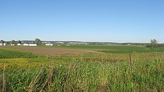
Governors Point, designed Site 95.18 by the Maine Archaeological Survey, is a prehistoric and historic archaeological site in Grand Lake Stream, Maine. With a documented record of historical occupation into the 19th century by the Passamaquoddy people, and archaeological evidence spanning nearly 3000 years of habitation, the site is one of the most important in eastern Maine. The site was listed on the National Register of Historic Places in 2001.

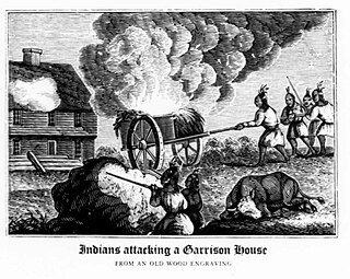
The Battle of Falmouth involved Joseph-François Hertel de la Fresnière and Baron de St Castin leading troops as well as the Wabanaki Confederacy in New Brunswick to capture and destroy Fort Loyal and the English settlement on the Falmouth neck, then part of the Massachusetts Bay Colony. The commander of the fort was Captain Sylvanus Davis. After two days of siege, the settlement's fort, called Fort Loyal, surrendered. The community's buildings were burned, including the wooden stockade fort, and its people were either killed or taken prisoner. The fall of Fort Loyal (Casco) led to the near depopulation of Europeans in Maine. Native forces were then able to attack the New Hampshire frontier without reprisal.
The Kolmer Site is an archaeological site in the far southwest of the U.S. state of Illinois. Located near Kaskaskia and Prairie du Rocher in western Randolph County, it lies at the site of an early historic Indian village from the French period. Because it occupies a critical chronological and cultural position, it has been given national recognition as a historic site.
Fort Menaskoux was a British colonial fort in present-day Arrowsic, Maine.

Ntolonapemk, also known as the Eastern Surplus Company Superfund Site and Maine State Survey No. 96.02, is a prehistoric archaeological site in Meddybemps, a small town in Washington County, Maine. Located near the outlet of Meddybemps Lake, it is one of the only major inland prehistoric habitation sites in the county, with evidence of more than 8,000 years of use. The site was listed on the National Register of Historic Places in 2001.
The Northeast Coast Campaign (1676) happened during King Philips War and involved the Wabanaki Confederacy raiding colonial American settlements along the New England Colonies/Acadia border in present-day Maine. In the first month, they laid waste to 15 leagues of the coast east of Casco. They killed and captured colonists and burned many farms, blunting the tide of colonial American expansion. The Campaign of 1676 led the colonists to abandon the region, retreating to Salem, Massachusetts. The Campaign is most notable for Richard Waldron entering the war, the death of Chief Mogg and the attack on the Mi’kmaq that initiated their involvement in the war.
Archeological Site No. 74-2 is a prehistoric site in Indian Island, Maine. Located on a terrace above the Penobscot River, the site dates to the Middle Archaic Period, a rarity in Maine, made even more unusual by the absence of later period artifacts. The site was listed on the National Register of Historic Places in 1984, for its potential to increase what is known about Native settlement patterns in the area.

The Moccasin Bluff Site is an archaeological site located along Red Bud Trail and the St. Joseph River north of Buchanan, Michigan. It was listed on the National Register of Historic Places in 1977, and has been classified as a multi-component Prehistoric site with the major component dating to the Late Woodland/Upper Mississippian period.
References
- 1 2 "National Register Information System". National Register of Historic Places . National Park Service. July 9, 2010.
- ↑ Baker, pp. 1-11
- ↑ Baker, p. 12
- ↑ Baker, p. 14
- ↑ Baker, p. 15
- ↑ Baker, pp. 17-20