
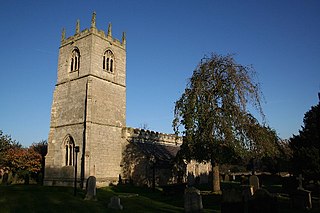
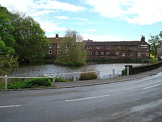
Hooton Pagnell is a village and civil parish in the Metropolitan Borough of Doncaster in South Yorkshire, England, on the border with West Yorkshire. It lies on the B6422 road, between Brodsworth and South Elmsall and is at an elevation of around 78 metres (256 ft) above sea level. It had a population of 211 at the 2001 Census, reducing slightly to 201 at the 2011 Census. The name of the village derives from Ralph de Paganel, a Norman who was a tenant-in-chief in Yorkshire named in the Domesday Book and an extensive landowner.

Cawthorne is a village and civil parish in the Metropolitan Borough of Barnsley, South Yorkshire, England. The village was once a centre of the iron and coal mining industry; today it is part of an affluent commuter belt west of Barnsley. At the 2001 census it had a population of 1,108, increasing to 1,151 at the 2011 Census.

Roos is a village and civil parish in the East Riding of Yorkshire, England. It is situated 12 miles (19 km) east from Kingston upon Hull city centre and 3.5 miles (6 km) north-west from Withernsea, and on the B1242 road.

Walkington is a village and civil parish in the East Riding of Yorkshire, England. It is situated approximately 3 miles (4.8 km) to the south-west of the town of Beverley on the B1230 road, and Beverley Grammar School.

Mappleton is a village and civil parish in the East Riding of Yorkshire, England. It is situated on the North Sea coastline in an area known as Holderness, lying approximately 3 miles (5 km) south of the seaside resort of Hornsea. The civil parish is formed by the village of Mappleton and the hamlets of Cowden, Great Cowden and Rolston. According to the 2011 UK census, Mappleton parish had a population of 342, an increase on the 2001 UK census figure of 249.

Rawcliffe is a village and civil parish in the East Riding of Yorkshire, England on the border with North Yorkshire. It is situated approximately 4 miles (6.4 km) west of Goole and 17 miles (27 km) south of York. It lies on the banks of the River Aire just north of the M62 and on the A614 road. Rawcliffe, along with nearby Airmyn, was the location of one of the first reliable reports of the practice of warping in agriculture in the 1730s.

Bainton is a village and civil parish in the East Riding of Yorkshire, England. It is situated approximately 6 miles (10 km) south-west of Driffield on the A614 road.
Braithwell is a village and civil parish in the Metropolitan Borough of Doncaster in South Yorkshire, England. It is about 1 mile (1.6 km) north from Maltby and 3 miles (5 km) south-east from Conisbrough. According to the 2001 Census the civil parish had a population of 1,056, increasing slightly to 1,060 at the 2011 Census.
Brodsworth is a village and civil parish in the City of Doncaster district in South Yorkshire, England. Situated about five miles north-west of Doncaster city centre, the parish also includes Scawsby. According to the 2001 census, it had a population of 2,875, increasing to 2,936 at the 2011 Census.
Brompton is a civil parish in the Scarborough district of North Yorkshire, England, containing the villages of Brompton-by-Sawdon and Sawdon.

Brotherton is a village and civil parish in the Selby District of North Yorkshire, England. The village is on a border with the City of Wakefield and West Yorkshire.

Bugthorpe is a village and civil parish in the East Riding of Yorkshire, England, about 11 miles (18 km) east of York and 16 miles (26 km) west of Driffield. The village is just south of the border with North Yorkshire. According to the 2011 UK Census the civil parish had a population of 103, a decrease on the 2001 UK Census figure of 122.

Wykeham is a small village and civil parish in the Scarborough district of North Yorkshire, England, on the outskirts of Scarborough and the southern boundary of the North York Moors National Park.
Staveley is a village and civil parish in the Harrogate district of North Yorkshire, England. It is situated 4 miles (6.4 km) north of Knaresborough and near the A1(M) motorway. In the 2001 census, the village had a population of 444, which had risen to 450 by the time of the 2011 census. In 2015, North Yorkshire County Council estimated the population to have dropped to 440.

Shiptonthorpe is a village and civil parish in the East Riding of Yorkshire, England. It is situated approximately 5 miles (8 km) south-east of the market town of Pocklington and 2 miles (3.2 km) north-west of the market town of Market Weighton.

Preston is a village and civil parish in the East Riding of Yorkshire, England, in an area known as Holderness. It is situated approximately 6 miles (10 km) east of Hull city centre it lies just north of the A1033 road on the crossroads between the B1240 and B1362 roads.
North Dalton is a village and civil parish in the East Riding of Yorkshire, England. It is situated approximately 6 miles (10 km) south-west of the town of Driffield and 8 miles (13 km) north-east of the town of Pocklington. 4 miles (6.4 km) to the north-west lies the village of Huggate. South Dalton lies some 4.5 miles (7 km) to the south-east, with villages in between. North Dalton itself lies on the B1246 road.

Lund is a village and civil parish in the East Riding of Yorkshire, England. It is situated approximately 6 miles (10 km) north-west of Beverley and 7 miles (11 km) south-west of Driffield.

Hook is a village and civil parish in the East Riding of Yorkshire, England. It is situated approximately 1.5 miles (2.4 km) north-east of Goole town centre and lies on the west bank of the River Ouse.
Halsham is a village and civil parish in the East Riding of Yorkshire, England, in an area known as Holderness. It is situated approximately 4 miles (6.4 km) west of Withernsea town centre and it lies south of the B1362 road.


