Clifton-upon-Teme

Last updated
Clifton-upon-Teme
The Lion, Clifton-upon-Teme.jpg
Worcestershire UK location map.svg
Red pog.svg
Clifton-upon-Teme
Clifton-upon-Teme shown within Worcestershire
Civil parish
  • Clifton-upon-Teme
District
Shire county
Region
Country England
Sovereign state United Kingdom
Post town Worcester
Postcode district WR6
Police West Mercia
Fire Hereford and Worcester
Ambulance West Midlands
EU Parliament West Midlands
List of places
UK
England
Worcestershire
52°15′11″N2°25′16″W / 52.253°N 2.421°W / 52.253; -2.421 Coordinates: 52°15′11″N2°25′16″W / 52.253°N 2.421°W / 52.253; -2.421

Clifton-upon-Teme is a village and civil parish in the Malvern Hills District in the county of Worcestershire, England.

Civil parish territorial designation and lowest tier of local government in England, UK

In England, a civil parish is a type of administrative parish used for local government, they are a territorial designation which is the lowest tier of local government below districts and counties, or their combined form, the unitary authority. Civil parishes can trace their origin to the ancient system of ecclesiastical parishes which historically played a role in both civil and ecclesiastical administration; civil and religious parishes were formally split into two types in the 19th century and are now entirely separate. The unit was devised and rolled out across England in the 1860s.

Worcestershire County of England

Worcestershire is a county in the West Midlands of England. Between 1974 and 1998, it was merged with the neighbouring county of Herefordshire as Hereford and Worcester.

Contents

Amenities

Named after the River Teme which runs nearby, it has a village shop, parish church (dedicated to Saint Kenelm), nursery and primary school, village hall, veterinary surgery, garage and two pubs, the New Inn and the Lion.

River Teme river in Wales and England

The River Teme rises in Mid Wales, south of Newtown, and flows through Knighton where it crosses the border into England down to Ludlow in Shropshire, then to the north of Tenbury Wells on the Shropshire/Worcestershire border there, on its way to join the River Severn south of Worcester. The whole of the River Teme was designated as an SSSI, by English Nature, in 1996.

Parish church church which acts as the religious centre of a parish

A parish church in Christianity is the church which acts as the religious centre of a parish. In many parts of the world, especially in rural areas, the parish church may play a significant role in community activities, often allowing its premises to be used for non-religious community events. The church building reflects this status, and there is considerable variety in the size and style of parish churches. Many villages in Europe have churches that date back to the Middle Ages, but all periods of architecture are represented.

Saint Kenelm 9th-century King of Mercia and saint

Saint Kenelm was an Anglo-Saxon saint, venerated throughout medieval England, and mentioned in the Canterbury Tales. William of Malmesbury, writing in the 12th century, recounted that "there was no place in England to which more pilgrims travelled than to Winchcombe on Kenelm's feast day".

Notable features

There are two grade II* buildings in Clifton-upon-Teme: the parish church of St Kenelm, [1] and Woodmanton Farmhouse. [2] and further 44 grade II listed buildings or structures. [3] Located outside the village at the bottom of the escarpment (and close to the river Teme), but within the parish is Ham Castle Farm which is the location of three grade II listed buildings and one other grade II structure. [3] [4] Close to it are the earthworks remains of Ham Castle. [5]

Ham Castle

Ham Castle is located in Worcestershire at the bottom of a wooded escarpment, within the parish of Clifton-upon-Teme, about 1 mile (1.6 km) east of the village of Clifton-upon-Teme and 4 miles (6.4 km) south of Great Witley.

History

The village is an excellent example of an Anglo-Saxon settlement overlooking the River Teme, situated on the ancient salt route that led from Droitwich to Leominster.

Salt mineral used as ingredient, composed primarily of sodium chloride (NaCl)

Salt is a mineral composed primarily of sodium chloride (NaCl), a chemical compound belonging to the larger class of salts; salt in its natural form as a crystalline mineral is known as rock salt or halite. Salt is present in vast quantities in seawater, where it is the main mineral constituent. The open ocean has about 35 grams (1.2 oz) of solids per liter of sea water, a salinity of 3.5%.

Leominster town in Herefordshire, England

Leominster is a market town in Herefordshire, England, and is located at the confluence of the River Lugg and its tributary the River Kenwater, approximately 12 miles (19 km) north of the city of Hereford and approx 7 miles south of the Shropshire boundary, 11 miles from Ludlow in Shropshire. With a population of approximately 11,700 people, Leominster is the largest of the five towns in the county surrounding the City of Hereford.

The earliest surviving mention of the village is in the Latin charter of King Athelstan, granting it to the monks of St. Peter's Monastery in Worcester in 934 AD when it was referred to as Clistun ultra Tame.

Latin Indo-European language of the Italic family

Latin is a classical language belonging to the Italic branch of the Indo-European languages. The Latin alphabet is derived from the Etruscan and Greek alphabets, and ultimately from the Phoenician alphabet.

Charter grant of authority or rights

A charter is the grant of authority or rights, stating that the granter formally recognizes the prerogative of the recipient to exercise the rights specified. It is implicit that the granter retains superiority, and that the recipient admits a limited status within the relationship, and it is within that sense that charters were historically granted, and that sense is retained in modern usage of the term.

Monk religious occupation

A monk is a person who practices religious asceticism by monastic living, either alone or with any number of other monks. A monk may be a person who decides to dedicate his life to serving all other living beings, or to be an ascetic who voluntarily chooses to leave mainstream society and live his or her life in prayer and contemplation. The concept is ancient and can be seen in many religions and in philosophy.

During the time of the wars with the Welsh, the manor of Clifton became established and was granted Royal Borough status by Edward III of England in 1377, allowing it to hold a weekly market on Thursdays and an annual four-day fair. The original manor house, built around 1200 on the site of the present Lion Inn, eventually came to be used as a hostelry for travellers en route between Worcester and Tenbury Wells.

Welsh people nation and ethnic group native to Wales

The Welsh are a Celtic nation and ethnic group native to, or otherwise associated with, Wales, Welsh culture, Welsh history and the Welsh language. Wales is a country that is part of the United Kingdom, and the majority of people living in Wales are British citizens.

Manorialism economic and judicial Institution

Manorialism was an essential element of feudal society. It was the organizing principle of rural economy that originated in the Roman villa system of the Late Roman Empire, and was widely practiced in medieval western and parts of central Europe as well as China. It was slowly replaced by the advent of a money-based market economy and new forms of agrarian contract.

Edward III of England 14th-century King of England and Duke of Aquitaine

Edward III was King of England and Lord of Ireland from January 1327 until his death; he is noted for his military success and for restoring royal authority after the disastrous and unorthodox reign of his father, Edward II. Edward III transformed the Kingdom of England into one of the most formidable military powers in Europe. His long reign of 50 years was the second longest in medieval England and saw vital developments in legislation and government, in particular the evolution of the English parliament, as well as the ravages of the Black Death.

Clifton-upon-Teme was in the upper division of Doddingtree Hundred. [6]

Following the Poor Law Amendment Act 1834 Clifton-upon-Teme Parish ceased to be responsible for maintaining the poor in its parish. This responsibility was transferred to Martley Poor Law Union. [7]

Related Research Articles

Abberley village in the United Kingdom

Abberley is a village and civil parish in north west Worcestershire, England.

Leigh, Worcestershire village in United Kingdom

Leigh is a village and civil parish in the Malvern Hills district of the county of Worcestershire, England.

Great Witley village and parish in Worcestershire, England

Great Witley is a village and civil parish, in the Malvern Hills District in the northwest of the county of Worcestershire, England. It is situated around ten miles to the north west of the city of Worcester.

Martley village in the United Kingdom

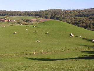
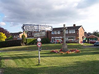
Martley is a village and civil parish in the Malvern Hills district of the English county of Worcestershire. It is approximately nine miles north-west of Worcester. The population of the village is approximately 1,200 people. The mixed farming of the area includes arable, formerly cherry, apple, damson orchards and hopyards.

Alfrick village in the United Kingdom

Alfrick is a village and civil parish in the Malvern Hills district of Worcestershire, England, about seven miles west of Worcester.

Stockton on Teme village in United Kingdom

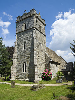
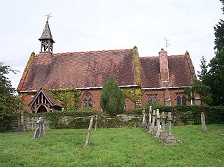
Stockton on Teme is a village and civil parish in the Malvern Hills District in the county of Worcestershire, England. It is close to the River Teme and is noted for its 12th century Norman church with an unusual circular graveyard.(photo).

Broadwas village in United Kingdom

Broadwas or Broadwas-on-Teme, is a village and civil parish in the Malvern Hills district of Worcestershire, England. According to the 2001 census it had a population of 307. The village is located on the River Teme, about 6 miles west of Worcester on the A44 road.

Cotheridge village in United Kingdom

Cotheridge is a village and civil parish in the district of Malvern Hills in the county of Worcestershire, England. It is 4 miles (6 km) west of the city of Worcester and a mile north-east of the Leigh Court railway station on the Great Western Railway on the opposite side of the River Teme.
The River Teme flows on the southern and south-western part of the village where the land is low-lying and is susceptible to flooding. The soil content is loam and clay with the subsoil being Keuper Marl.

Grimley, Worcestershire village in the United Kingdom

Grimley is a village and civil parish in the Malvern Hills District in the county of Worcestershire, England about 3 miles (4.8 km) north of Worcester.

Bransford village in the United Kingdom

Bransford is a village and civil parish in the Malvern Hills district of the county of Worcestershire, England. It is situated close to the River Teme and the village of Leigh. It is on the primary route between Worcester and Hereford, the A4103 that runs through the centre of the village. According to the 2011 census, Bransford has a population of 389. The parish shares its parish council with Leigh.

Knightwick village in the United Kingdom

Knightwick is a small village and civil parish in the Malvern Hills district in the county of Worcestershire, England.

Pensax village in the United Kingdom

Pensax is a village and civil parish of northwest Worcestershire in England, incorporating the hamlet of Menithwood to the west of Pensax Common. According to the 2001 census, the parish had a population of 317.

Shelsleys

The Shelsleys are a group of small villages in the Malvern Hills District in the county of Worcestershire, England. The Shelsleys are near the village of Clifton-upon-Teme the Teme Vally, and they encompass the three very distinct hamlets and civil parishes Shelsley Beauchamp, Shelsley Kings and Shelsley Walsh. The three parishes share a parish council.

Lulsley village in United Kingdom

Lulsley is a village and civil parish in the Malvern Hills District of the county of Worcestershire, England, UK.

Wichenford village in the United Kingdom

Wichenford is a village and civil parish in the Malvern Hills District in the county of Worcestershire, England. It lies 6 miles to the north-west of the city of Worcester.

Shrawley village and civil parish in the Malvern Hills District in the county of Worcestershire, England

Shrawley is a village and civil parish in the Malvern Hills District in the county of Worcestershire, England. The village is situated on the western bank of the River Severn. The northern and southern boundaries of the parish are two small tributaries of the River Severn, Dick Brook to the north and Shrawley Brook to the south. To the west is Hillhampton, the north west and north is the parish of Astley and to the south Holt.

Stanford-on-Teme village in United Kingdom

Stanford-on-Teme is a village and, with the village of Orleton just under a mile away, is also a civil parish in the Malvern Hills District in the county of Worcestershire, England.

The Hundred of Doddingtree was granted to Ralph Todeni, or Ralph de Toni, a relative of the Duke of Normandy, in 1066 by William the Conqueror as a reward for his services as Standard bearer during the Norman Conquest. It consisted mainly of west Worcestershire.

Following the Poor Law Amendment Act 1834 individual parishes ceased to be responsible for maintaining the poor in their parish. Poor law unions were established. In west Worcestershire the Martley Poor Law Union was established to take the poor from the following parishes Abberley, Alfrick, Astley, Bransford, Broadwas, Clifton-upon-Teme, Cotheridge, Doddenham, Great Witley, Grimley, Hallow, Holt, Knightwick, Leigh, Little Witley, Lulsley, Martley, Pensax, Shelsley, Shrawley, Suckley and Wichenford.

References

  1. Historic England. "Church of St Kenelm (1083009)". National Heritage List for England . Retrieved 16 October 2013.
  2. Historic England. "Woodmanton Farmhouse, kitchen, outbuildings and tower base (1302591)". National Heritage List for England . Retrieved 16 October 2013.
  3. 1 2 Goodge, Mark (16 October 2013). "Listed Buildings in Clifton upon Teme, Worcestershire, England". BritishListedBuildings.co.uk. Retrieved 16 October 2013.
  4. "Ham Castle Farm, Clifton upon Teme, England (Record Id: 1595)". parksandgardens.org. 2012. Retrieved 16 October 2013.
  5. Historic England. "Motte and bailey (Ham Castle) at Ham Farm (1005278)". National Heritage List for England . Retrieved 16 October 2013.
  6. Worcestershire Family History Guidebook, Vanessa Morgan, 2011, p20 The History Press, Stroud, Gloucestershire.
  7. Worcestershire Family History Guidebook, Vanessa Morgan, 2011, p68 The History Press, Stroud, Gloucestershire.