Colesbourne

Last updated

Colesbourne
Colesbourne church - geograph.org.uk - 129381.jpg
St James' Church
Gloucestershire UK location map.svg
Red pog.svg
Colesbourne
Location within Gloucestershire
OS grid reference SO999132
  London 85 mi (137 km)  WNW
District
Shire county
Region
Country England
Sovereign state United Kingdom
Post town Cheltenham
Postcode district GL53
Dialling code 01242
Police Gloucestershire
Fire Gloucestershire
Ambulance South Western
UK Parliament
List of places
UK
England
Gloucestershire
51°49′05″N2°00′08″W / 51.8180°N 2.00213°W / 51.8180; -2.00213

Colesbourne is a village and civil parish in the Cotswold district of Gloucestershire, England. The village and parish lies within the Cotswolds, a designated Area of Outstanding Natural Beauty.

Contents

The village is 10 miles (16 km) east-southeast from the city and county town of Gloucester, and on a 1,000 yards (900 m) east to west section (defined by road entry signs) of the A435 road, which runs locally between Cheltenham 6 miles (10 km) to the north, and Cirencester, 7 miles (11 km) to the south. The civil parish is 4.5 miles (7 km) from north to south. Withington parish is at the north and north-east, with North Cerney and Rendcomb at the south. At the north-west is Coberley parish; at the west, Elkstone; and at the east, Chedworth. The River Churn flows through the centre of the parish and at the north of the village, where it is joined by its tributary Hilcot Brook, which rises in the farther north parish of Dowdeswell. [2] [3]

The village contains The Colesbourne Inn public house, adjacent to a restaurant, a roadside fuel station, and a village farm with a small retail park which includes a cookery school and wine merchant. At the north of the village is the parish church of St James, and north from this is the house of Colesbourne Park estate. [2] Colesbourne is connected by bus to Cheltenham and Swindon. [4]

In 1872 John Marius Wilson recorded Colesbourne as being a parish in the Cirencester district, near the highest source of the River Thames and 3 miles (5 km) east from the Roman road of "Ermine-street", actually Ermin Way (today's A417). Remains of a Roman villa had been found. There was a post office and fifty-two houses in a parish area of 2,200 acres (9 km2). Colesbourne Park was the seat of Henry John Elwes, who was patron of the ecclesiastical parish rectory. [5]

Landmarks

There are sixteen Grade II listed buildings and structures in the parish. In the village is St James' Church, dating to the 12th century, with later 15th-century tower and chancel, which was largely rebuilt in 1852–53 for Henry John Elwes in early Perpendicular style. [5] [6] Within the churchyard is an 18th-century tomb to John Brown (d.1760), Mary Brown (d.1736), and Mary Hayden (d.1809). [7] At the southeast of the church is the base of a medieval cross with the remains of a 17th- or 18th-century stone sundial. [8] To the northeast of the church are three listed mid-19th-century coachhouses built for Henry John Elwes of Colesbourne Park. [9] [10] [11]

On the A435 at the centre of the village is The Colesbourne Inn, a coaching inn dating to 1827, which was "built to serve the new Cheltenham [to] Cirencester turnpike". [12] To the west of the inn is the building listed as the 'Village Institute and Coach House', a c.1827 "former stables and coach house, now partly meeting hall". [13] Farther west, and adjacent, is the c.1850 'Village Stores and Post Office'. [14] To the east of The Colesbourne Inn is the c.17th-century Slys Cottage, a former shop and post office. [15] At the northwest of the village is Southbury Farmhouse, dating to the 17th century with 18th-century additions. [16] Adjacent to the farmhouse are mid- to late 18th century threshing barns and stables. [17] At the south of the parish is Rapsgate Park, a late 17th-century "large country house" which was "remodelled and enlarged in the 18th century and altered in 1903". [18] Next to Rapsgate Park is an 18th-century barn. [19] At the west and southeast of the village on the A435 are 19th-century milestones of iron plate. [20] [21]

At the north of the village, beyond St James' Church, and bordered at the east by Hilcot Brook, dammed in 1922 to form a lake, is Colesbourne Park, a house with 30 acres (120,000 m2) of garden and an arboretum, which was home to the botanist and author Henry John Elwes (1846–1922). The park is significant for its display of 250 cultivars of snowdrops, particularly Galanthus elwesii which was identified by and named after Elwes. [22] [23] [24] [25]

Related Research Articles

<span class="mw-page-title-main">Cirencester</span> Market town in Gloucestershire, England

Cirencester is a market town and civil parish in the Cotswold District of Gloucestershire, England. Cirencester lies on the River Churn, a tributary of the River Thames. It is the eighth largest settlement in Gloucestershire and the largest town within the Cotswolds. It is the home of the Royal Agricultural University, the oldest agricultural college in the English-speaking world, founded in 1840. The town had a population of 20,229 in 2021. The town is 18 miles (29 km) northwest of Swindon, 18 miles (29 km) southeast of Gloucester, 37 miles (60 km) west of Oxford and 39 miles (63 km) northeast of Bristol.

<span class="mw-page-title-main">Sherston, Wiltshire</span> Human settlement in England

Sherston is a village and civil parish about 5 miles (8 km) west of Malmesbury in Wiltshire, England. The parish is bounded to the north by the county boundary with Gloucestershire, and to the southeast by the Fosse Way, a Roman road. The parish includes the hamlets of Easton Town, immediately east of Sherston; Pinkney, further east along the Malmesbury road; and Willesley, to the north.

<span class="mw-page-title-main">Northleach</span> Market town in England

Northleach is a market town and former civil parish, now in parish Northleach with Eastington, in the Cotswold district, in Gloucestershire, England. The town is in the valley of the River Leach in the Cotswolds, about 10 miles (16 km) northeast of Cirencester and 11 miles (18 km) east-southeast of Cheltenham. The 2011 Census recorded the parish's population as 1,854, the same as Northleach built-up-area. The 2021 Census recorded the population as 1,931.

<span class="mw-page-title-main">Ampney St Mary</span> Village in Gloucestershire, England

Ampney St Mary is a small village and civil parish in the Cotswolds, part of the Cotswold District of Gloucestershire, England. According to the 2001 census the parish had a population of 54, increasing to 218 at the 2011 census.

<span class="mw-page-title-main">Ashton Keynes</span> Village in Wiltshire, England

Ashton Keynes is a village and civil parish in north Wiltshire, England which borders with Gloucestershire. The village is about 5 miles (8 km) south of Cirencester and 3.5 miles (5.6 km) west of Cricklade. At the 2011 census the population of the parish, which includes the hamlet of North End, was 1,400.

<span class="mw-page-title-main">Barnsley, Gloucestershire</span> Human settlement in England

Barnsley is a village and civil parish in the Cotswold district of Gloucestershire, England, 3.7 miles (6.0 km) northeast of Cirencester. It is 125 kilometres (78 mi) (geodesically) west of London.

<span class="mw-page-title-main">Hemingby</span> Dispersed village and civil parish in the East Lindsey district of Lincolnshire, England

Hemingby is a dispersed village and civil parish in the East Lindsey district of Lincolnshire, England. It is situated approximately 3 miles (5 km) north from the market town of Horncastle and just west from the junction of the B1225 and A158 roads. It is surrounded by the villages of Baumber, Goulceby and West Ashby. The River Bain and its tributary, the Hemingby Beck, flow through the village.

<span class="mw-page-title-main">Mells, Somerset</span> Village in Somerset, England

Mells is a village and civil parish in Somerset, England, near the town of Frome.

<span class="mw-page-title-main">Colerne</span> Village and civil parish in Wiltshire, England

Colerne is a village and civil parish in north Wiltshire, England. The village is about 3.5 miles (6 km) west of the town of Corsham and 7 miles (11 km) northeast of the city of Bath. It has an elevated and exposed position, 545 feet (166 m) above sea level, and overlooks the Box valley to the south.

<span class="mw-page-title-main">Somerford Keynes</span> Village in Gloucestershire, England

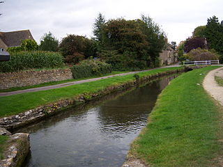
Somerford Keynes is a village and civil parish in the Cotswold district of Gloucestershire, England, close to the River Thames and about 5 miles from its source. It lies on the boundary with Wiltshire, midway between Cirencester, Swindon and Malmesbury. The parish population at the 2011 census was 479, and a 2019 estimate put it at 558. The parish includes the village of Shorncote.

<span class="mw-page-title-main">Stanton, Gloucestershire</span> Village in Gloucestershire, England

Stanton is a village and civil parish in Tewkesbury Borough, Gloucestershire, England. The village is a spring line settlement at the foot of the Cotswold escarpment, about 2.5 miles (4 km) southwest of Broadway in neighbouring Worcestershire. Broadway is Stanton's postal town. The 2011 Census recorded the parish's population as 198.

<span class="mw-page-title-main">Britwell Salome</span> Human settlement in England

Britwell Salome is a village and civil parish in South Oxfordshire, England centred 4+12 miles (7 km) northeast of Wallingford. The 2011 Census recorded the parish's population as 204.

<span class="mw-page-title-main">Withington, Gloucestershire</span> Village and civil parish in Gloucestershire, UK

Withington is a Cotswold village and civil parish in Gloucestershire, England, about 7 miles (11 km) southeast of Cheltenham and 8 miles (13 km) north of Cirencester. The River Coln runs through the village. The parish includes the hamlets of Hilcot, Foxcote and Cassey Compton. The parish population taken at the 2011 census was 532.

<span class="mw-page-title-main">Dodington Park</span> Country house in Gloucestershire, UK

Dodington Park is a country house and estate in Dodington, South Gloucestershire, England. The house was built by James Wyatt for Christopher Bethell Codrington. The family had made their fortune from sugar plantations in the Caribbean and were significant owners of slaves. It remained in the Codrington family until 1980; it is now owned by the British businessman James Dyson.

<span class="mw-page-title-main">Cowley, Gloucestershire</span> Village in Gloucestershire, England

Cowley is a village and civil parish in the Cotswold District of Gloucestershire, England. It lies between the A417 and A435 roads between Cheltenham and Cirencester in the Churn Valley, and has a population of 333. The name originates from 'cow' and 'leigh', literally meaning cow pasture.

<span class="mw-page-title-main">Sopworth</span> Human settlement in England

Sopworth is a small village and civil parish in northwest Wiltshire, England, on the county's border with Gloucestershire. The village lies about 1.7 miles (2.7 km) west of Sherston and 6.5 miles (10 km) west of Malmesbury. The parish is within the Cotswolds Area of Outstanding Natural Beauty.

<span class="mw-page-title-main">Crudwell</span> Village in England

Crudwell is a village and civil parish in north Wiltshire, England. The nearest towns are Malmesbury, about 4 miles (6.4 km) to the south-west, and Cirencester, Gloucestershire 8 miles (13 km) to the north-east. Also to the north-east is Cotswold Airport. Kemble village, about 4 miles (6.4 km) away, has the nearest railway station, with services to London Paddington and Gloucester.

Sir Henry William George Elwes is a retired British politician and public servant. He served as a District and County Councillor in Gloucestershire for 32 years and was Lord Lieutenant of Gloucestershire between 1992 and 2010.

<span class="mw-page-title-main">Tidmington</span> Human settlement in England

Tidmington is a village and civil parish in the Stratford-on-Avon District of Warwickshire, England. It is 11 miles (18 km) south from the town of Stratford-upon-Avon, and at the extreme southern edge of the county bordering Gloucestershire. Within the parish is the Grade II* listed c.1600 Tidmington House, and the Grade II* early 13th-century church of unknown dedication. At the 2001 Census, which for statistical purposes now includes the neighbouring parish of Burmington, the combined population was 153.

<span class="mw-page-title-main">Todenham</span> Human settlement in England

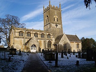
Todenham is a village and civil parish in the Cotswold district of Gloucestershire, England. The village is significant for its Grade I listed 14th-century parish church.

References

  1. "Location of North Cotswolds". parliament.uk. Retrieved 16 January 2025.
  2. 1 2 Extracted from "Colesbourne", Ordnance Survey map. Retrieved 28 January 2019
  3. Extracted from "Colesbourne" Grid Reference Finder. Retrieved 28 January 2019
  4. "Colesbourne Inn (after)", Bus Times. Retrieved 28 January 2019
  5. 1 2 Wilson,John, Marius (1870-72) Imperial Gazetteer of England and Wales
  6. Historic England. "Church of St James (1341787)". National Heritage List for England . Retrieved 28 January 2019.
  7. Historic England. "Brown Monument in the Churchyard Approximately 5 Metres North of Church of St James (1088454)". National Heritage List for England. Retrieved 28 January 2019.
  8. Historic England. "Cross Base in the Churchyard Approximately 2 Metres South of Chancel to Church of St James (1088453)". National Heritage List for England. Retrieved 28 January 2019.
  9. Historic England. "East Coach House at Colesbourne Park (1341788)". National Heritage List for England. Retrieved 28 January 2019.
  10. Historic England. "West Coach House at Colesbourne Park (1088455)". National Heritage List for England. Retrieved 28 January 2019.
  11. Historic England. "North Coach House at Colesbourne Park (1171472)". National Heritage List for England. Retrieved 28 January 2019.
  12. Historic England. "Colesbourne Inn (1088450)". National Heritage List for England. Retrieved 28 January 2019.
  13. Historic England. "Village Institute and Coach House (1088451)". National Heritage List for England. Retrieved 28 January 2019.
  14. Historic England. "Village Stores and Post Office (1341786)". National Heritage List for England. Retrieved 28 January 2019.
  15. Historic England. "Slys Cottage (1341785)". National Heritage List for England. Retrieved 28 January 2019.
  16. Historic England. "Southbury Farmhouse (1305597)". National Heritage List for England. Retrieved 28 January 2019.
  17. Historic England. "Threshing Barns and Stables at Southbury Farm (1392977)". National Heritage List for England. Retrieved 28 January 2019.
  18. Historic England. "Rapsgate Park (1088456)". National Heritage List for England. Retrieved 28 January 2019.
  19. Historic England. "Barn at Rapsgate Park (1171491)". National Heritage List for England. Retrieved 28 January 2019.
  20. Historic England. "Milestone (1088449)". National Heritage List for England. Retrieved 28 January 2019.
  21. Historic England. "Milestone (1088452)". National Heritage List for England. Retrieved 28 January 2019.
  22. "Colesbourne Park". Colesbourne Park 'England's Greatest Snowdrop Garden'. Colesbourne Gardens LLP. 2011.
  23. "Colesbourne Park", Gardens of Great Britain. Retrieved 28 January 2019
  24. Lacey, Stephen; "The whites of spring: seasonal snowdrops", The Telegraph , 21 January 2012. Retrieved 28 January 2019
  25. Shepherd, Charlotte;"Colesbourne Park is ready to reveal its snowdrops", Wilts and Gloucestershire Standard, 22 January 2013. Retrieved 28 January 2019