
Hartford is one of five unincorporated villages in the town of Hartford, Windsor County, Vermont, United States. It also referred to as Hartford Village.

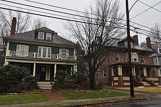
The West End South Historic District encompasses a neighborhood of mid 19th to early 20th century residential architecture in western Hartford, Connecticut and eastern West Hartford, Connecticut. Roughly bounded by Prospect and South Whitney Streets, West Boulevard, and Farmington Avenue, the area includes a large number of Colonial Revival and Queen Anne houses, as well as numerous buildings in other period styles, with only a small number of losses. It was listed on the National Register of Historic Places in 1985.

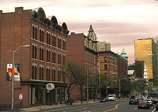
The Downtown North Historic District is a 19-acre (7.7 ha) historic district in Hartford, Connecticut. It is a predominantly residential area located around Main Street and High Street north of I-84 and south of the Amtrak railroad tracks. Its apartment blocks, houses, schools and churches, built up mainly in the late 19th and early 20th centuries as part of an expansion of the city's urban core. It includes the 130-foot (40 m) Keney Tower. The area was listed on the National Register of Historic Places in 2004.

Newington Junction is a section of the town of Newington, Connecticut. It is centered at the intersection of Willard Avenue and West Hill Road in the northwestern part of the town, in the area generally just south of the Hartford city line. The name of the area refers to the railroad junction where the railroad line from New Haven meets with the railroad line from Bristol and Waterbury. The development of Newington Junction as a result of the railroad was instrumental in the separation of the town of Newington from its mother town of Wethersfield.

The Church of the Good Shepherd and Parish House is an Episcopal church at 155 Wyllys Street in Hartford, Connecticut. It was commissioned by Elizabeth Jarvis Colt, the widow of Samuel Colt and completed in 1867. The church and its associated parish house were designed by Edward Tuckerman Potter, and serve as a memorial to Samuel Colt and members of his family. The church and parish house were added to the National Register of Historic Places in 1975, and became a contributing property to the Coltsville Historic District in 2008.

The Humphrey Pratt Tavern is a historic house at 287 Main Street in Old Saybrook, Connecticut. Built in 1785, it was associated with the locally prominent Pratt family for many years, and served as a tavern and stagecoach stop in the 18th and 19th centuries. It was listed on the National Register of Historic Places in 1976.

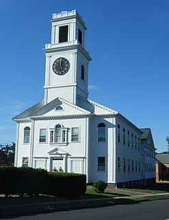
The Broad Street Green Historic District encompasses the historic late-19th century town center of Windsor, Connecticut. It is centered around the Broad Street Green, a public park extending on the east side of Broad Street between Union and Batchelder Streets, and includes a diversity of architecture spanning much of the town's long history. It was listed on the National Register of Historic Places in 1999.
The Buckingham Square District of Hartford, Connecticut encompasses a mixed residential and commercial neighborhood area just south of the city's downtown. It is centered around Buckingham Square, laid out in 1830 on the site of an early colonial-era church. The district includes a concentration of well-preserved Victorian architecture from the 1860s to 1890s. It was listed on the National Register of Historic Places in 1977, and slightly enlarged in 1982.

The James B. Colt House is a historic house at 154 Wethersfield Avenue in Hartford, Connecticut. Built in 1855, it is a high-quality example of Italianate architecture. It was built for James B. Colt, the brother of industrialist Samuel Colt, whose Armsmear estate is just to the north. The house was listed on the National Register of Historic Places in 1975.

140 and 144 Retreat Avenue is a historic conjoined pair of houses in Hartford, Connecticut. Built in 1844 and 1851, the two houses are the only surviving reminders of the street's 19th-century streetscape. They were listed on the National Register of Historic Places in 1982.

The James Pratt Funeral Service was a historic house at 69 Farmington Avenue in Hartford, Connecticut. Built in 1860, it was one of the few surviving mid-19th-century houses on a once-residential stretch of that street. The house was listed on the National Register of Historic Places in 1979. It was subsequently demolished, and the property is now part of the Aetna campus.

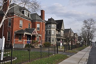
The Jefferson-Seymour District is a historic district encompassing a residential area on the south side of Hartford, Connecticut. Covering portions of Cedar, Wadsworth, Seymour and Jefferson Streets, it contains a well-preserved collection of late 19th and early 20th-century middle-class residential architecture, primarily executed in brick. It was listed on the National Register of Historic Places in 1979.

The Laurel and Marshall Streets District is a historic district encompassing a late-19th and early-20th century residential area in the Asylum Hill neighborhood of Hartford, Connecticut. Extending along Laurel and Marshall Streets between Niles and Case Streets, its housing stock represents a significant concentration of middle-class Queen Anne architecture in the city. It was listed on the National Register of Historic Places in 1979.

The Lewis Street Block is a historic district encompassing the southern half of Lewis Street and some adjacent buildings in downtown Hartford, Connecticut. The streetscape is reminiscent of a mid-19th century city street, with architecture extending from that period into the early 20th century. The district was listed on the National Register of Historic Places in 1976.
The Oxford-Whitney Streets District is a historic district encompassing an early-20th century residential area in the West End neighborhood of Hartford, Connecticut. It extends along the east side of Oxford Street between Elizabeth and Cone Streets, on the west side of Whitney between Fern and Elizabeth, and includes the north side of Fern Street between Whitney and Oxford. Most of the housing, a combination of single and multi-family residences, was built between 1906 and 1919, a period later than the surrounding areas, and is predominantly Colonial Revival in character. It was listed on the National Register of Historic Places in 2010.
The Parkside Historic District encompasses a fine collection of Queen Anne Victorian houses lining the east side of Wethersfield Avenue north of Wawarme Avenue in southern Hartford, Connecticut. This area was developed in the 1880s and 1890s by Mrs. Elizabeth Jarvis Colt, widow of arms manufacturer Samuel Colt, out of a portion of their extensive estate. Of this development, a row of nine houses now remains; it was listed on the National Register of Historic Places in 1984.
The Rocky Hill Center Historic District encompasses the traditional town center and surrounding residential area of Rocky Hill, Connecticut. It extends along Old Main Street from the Wethersfield line southward to a triangular area bounded by Old Main, Riverview Road, and Glastonbury Avenue. Included in a basically 19th-century streetscape are the town's principal civic and religious buildings, as well as a fine collection of mainly 18th and 19th-century residential architecture. The district was listed on the National Register of Historic Places in 2007.

The South Green Historic District encompasses a predominantly 19th-century residential area near the South Green of Hartford, Connecticut. This area features a variety of residences in both high and common styles, from the elaborate home of armsmaker Samuel Colt to multi-unit apartment houses, many of which were built between about 1860 and 1900. The district is roughly triangular, extending from South Green along Main Street and Wethersfield Avenue to include Morris, Dean, and Alden Streets. The district was listed on the National Register of Historic Places in 1977.

The Upper Albany Historic District encompasses a predominantly residential area of the North End of Hartford, Connecticut. It extends along Albany Avenue between Garden and Woodland Streets, including side streets to the south, and extends northward to include the southern portion of Keney Park. This area was developed in the first two decades of the 20th century, and has a fine array of period middle-class housing in the Queen Anne and Colonial Revival styles. It was listed on the National Register of Historic Places in 1986.

The Wethersfield Avenue Car Barn, also known locally just as the Trolley Barn, is a historic trolley barn at 331 Wethersfield Avenue in Hartford, Connecticut. Built in 1902, it is the only surviving building used exclusively for the area's extensive electrified street car network in the first half of the 20th century. Now converted to other uses, it was listed on National Register of Historic Places in 1983.


